By Nick Bond
Thunderstorms occur in the state of Washington relatively infrequently (Figure 1). There are about 20,000 lightning flashes per year on average (1996-2008), according to the National Lightning Detection Network. This sounds like a lot, but in terms of the frequency of flashes per unit area, Washington State actually ranks dead last compared to the rest of the continental United States. Given that it rains often, especially west of the Cascades, it may be a puzzle why our rains are so rarely accompanied by lightning. This issue is pursued in the present note.
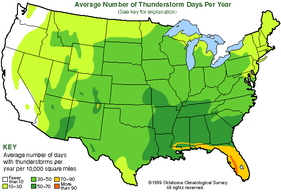 Figure 1: Average number of days with thunderstorms per year from the Oklahoma Climatological Survey.
It should be recognized that while lightning is uncommon in Washington State, particularly in the densely populated Puget Sound lowlands, severe thunderstorms do occur occasionally. Notably, an intense squall line moved through Vancouver, WA on 5 April 1972 that was accompanied by lightning and a F3 tornado. Washington State actually had the dubious distinction of leading the nation in fatalities (6) due to tornadoes that year. More recently, a series of strong thunderstorms hit eastern Washington during the first two weeks of July 2006 resulting in damaging hail and flash floods in a number of locations.
The process through which clouds become electrified, i.e., build up the large static charge that is released by lightning, is not fully understood. It appears that a common mechanism involves the interactions between graupel (large ice particles that have collected supercooled liquid water) and smaller ice particles. A decent rule of thumb is that active cumulus clouds must extend up at least as high as the -20 deg. C level. This temperature is found at roughly the 5-6 km level, and the active convection here does not often reach this high. Which begs the question, why not?
Deep cumulus convection is relatively uncommon in Washington State (and the Pacific Northwest in general) because of the lack of low-level air with high moisture content. The relative humidity is often high, but that is virtually always when it is also cool. We simply do not experience the combination of warm and muggy conditions that can plague other portions of the United States, particularly east of the Rocky Mountains in the summertime. The dewpoint temperature of the low-level air is comparable to the temperature of the last large body of water with which it has interacted, and there are no bodies of warm water upstream of the Pacific Northwest. A relatively low dewpoint temperature means there is less water vapor to condense and thereby represent a source of heat to generate the deep, vigorous convection typically required for a thunderstorm. In contrast, most of the thunderstorms that occur west of the Cascades are more characterized by cool air aloft, and many of their counterparts east of the Cascades are associated with the transport of moisture at mid-levels (~3 km) from the Great Basin region during summer. The more common thunderstorms that occur in the Cascades are generally associated with elevated heating and upslope-directed winds.
The numerical weather prediction (NWP) models in current use are reasonably effective for anticipating the prospects of thunderstorms out at least a few days, but will never be able to pinpoint their specific locations and timing more than a few hours into the future. There has not been much research on how the local frequency and distribution of lightning relates to the atmospheric circulation on seasonal time scales, but such information might prove useful from forest fire management and other perspectives. In closing, it is worth pointing out that while lightning is relatively rare in Washington, it obviously does occur, and it is prudent to be mindful of this threat while outdoors in certain conditions. If you see lightning or hear thunder, you should take action to minimize the threat, especially if in exposed locations like the mountains or on lakes. When thunder roars, go indoors!