Pollution due to Wood Smoke and the Weather of WA State
Air quality is often good in the Pacific Northwest due to the prevailing west to east winds off the North Pacific. There are exceptions to this situation, of course, during which residents of Washington are exposed to hazardous levels of air pollution. The primary pollution problem during the fall and winter is high concentrations of the small particulates less than 2.5 microns in diameter (PM2.5) associated with wood smoke. While the aroma of wood smoke is not necessarily unpleasant, and can have favorable connotations such as cozy evenings around the fireplace, the health impacts of this smoke are definitely negative. For example, University of Washington scientists Jane Koenig and Timothy Larson, along with collaborators, have found that children are more prone to asthma attacks and other respiratory problems in Puget Sound neighborhoods where wood smoke is prevalent. The issue is not just limited to the regions of high population density in Washington State. Following is a brief review of the weather conditions that promote the buildup of PM2.5, and what folks can do about it.
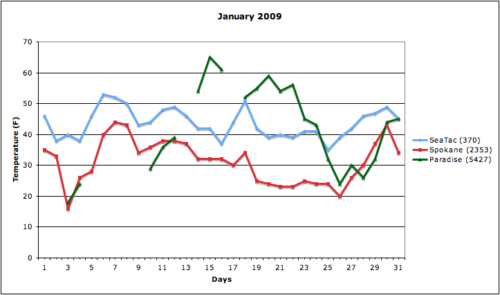
High concentrations of PM2.5 generally occur during periods of calm weather during the cool season. These periods feature a prominent ridge aloft, relatively high values of sea level pressure, and light winds. Their onset typically begins with clear skies followed by nighttime fog that may burn off during the day. During extended episodes of this kind of weather, the fog tends to persist through the day. Less frequently, the humidity is low enough such that fog is only in patches or absent, even at night. From an air quality point of view, the main problem is associated with the temperature inversion, i.e., a layer of air in which the temperature is increasing with height, that develops near the surface. This kind of temperature profile inhibits vertical mixing of air, resulting in trapping pollutants near the ground, thereby allowing their concentrations to increase to unhealthful levels. The extent to which this occurs varies substantially from place to place. In general, lower elevation regions such as the Puget Sound lowlands and the Columbia basin of eastern Washington are subject to stronger low-level inversions than higher elevations. A particularly striking example of this effect is illustrated by time series of daily maximum air temperature from SeaTac, Spokane, and Paradise Ranger Station on Mount Rainier for the month of January 2009 (Figure 1). A major air-stagnation event developed during the middle of the month and at its peak, the daytime high temperature at Paradise at about 5500’ elevation was more than 20 and 30 degrees F warmer than at SeaTac and Spokane, respectively. There are also much smaller-scale effects. Surveys carried out by the Puget Sound Clear Air Agency and others have revealed that local valleys, especially away from the water, are colder and experience much greater smoke concentrations than nearby areas. Fortunately, there are resources for monitoring the development of these events. Specifically, the wind profiler on the NOAA Sandpoint campus in Seattle, and the twice-daily rawinsonde soundings taken at Geiger Field outside Spokane provide measurements of the vertical profiles of the temperature and wind. With the help of other observations, we can track the development of these episodes, but can we anticipate them in the first place?
The overall weather pattern favoring stagnant conditions and poor air quality in the cool season can be predicted quite reliably on time horizons of a week or so. Current numerical weather prediction (NWP) models still do not get the details exactly right, but on these time scales are actually quite remarkable in their ability to project major transitions in the weather. On seasonal and longer time scales it is a different matter. Presumably the large-scale atmospheric circulation on these time scales relates to the frequency and severity of these events, but the relationship(s) here are unknown (and arguably something we should figure out). Moreover, we have only modest ability to project seasonal weather anomalies in the first place. It bears emphasizing that virtually every cool season includes some events, and so it is worthwhile to consider what actions can be taken as individuals.
First and foremost, we can all do our part to reduce wood smoke in the first place. It is best to have small and hot fires with seasoned wood. Certified wood stoves tend to be both more efficient and produce less smoke than older models. In general, highly visible smoke out of the chimney is a bad sign. A single smoky fire can pollute an entire neighborhood in certain conditions. It is especially important to limit burning to the extent possible when local authorities raise warnings or burn bans. These notices are now being included in forecasts available from the National Weather Service and are being better communicated by the media. For those with special interest in short-term forecasts of air quality in the Pacific Northwest, Washington State University provides a web site (https://airpact.wsu.edu/) with predictions using state-of-the-art atmospheric and chemical models. This information may be especially relevant to those with compromised respiratory systems in that it can be used to help limit the exposure to air pollution.