By Nick Bond
As summarized in this newsletter, it was a remarkably cool and wet April for Washington state in 2011. All the grumbling about the lousy weather, in particular the common lament that it seemed like winter was never going to end, begs an interesting question. When does spring normally occur in the state? Aside from the astronomical definition based on the length of day, there is no simple and easy answer. In other words, there are a variety of reasonable ways to define spring, or any other season for that matter, depending on one’s interests and perspectives.
For the public in general, it may depend on location. Residents of the wetter west side of the state probably care more about how often it rains, while perhaps those subject to the more continental weather to the east of the Cascade Mountains are more impacted by temperatures. By the first of these measures, the Puget Sound region typically experiences a decline in frequency of rainy days in early March (as illustrated in Figure 1 using data from Sea-Tac), which therefore could be considered the beginning of spring. The average frequency of measurable rain decreases more or less steadily to its minimum at the end of July so there is no clear indication of a transition from spring to summer in this parameter. By way of comparison, the means and extremes in daily temperatures from Spokane (Figure 2) may suggest that spring starts near the end of March, when mean low temperatures rise above freezing, and mean highs reach the mid-50s. Perhaps the last week of May marks the end of spring at this location because by that time of year daytime high temperatures average near 70 degrees and it is possible to get truly hot days with high temperatures in the upper 90s. Another potential measure is the percentage of possible sunshine, i.e., cloudiness. This may be especially meaningful west of the Cascades, where even though it typically rains more in May than in June, the latter month tends to include plenty of days with persistent decks of stratus clouds. In other words, perhaps spring on the west side extends from when it starts raining less in March until the sun shines more consistently in July; on the east side spring arguably is half as long, with the months of April and May separating the chill of winter from the heat of summer.
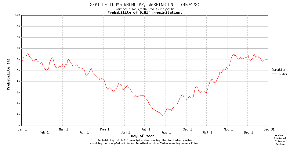 Figure 1: The daily probability of greater than 0.01” of precipitation using the period of record at SeaTac (from WRCC).
 Figure 2: The daily max, min, and extreme temperatures for Spokane Airport using the period of record (from WRCC).
The idea that spring is shorter east of the Cascades has some support from an agricultural point of view. The daily probability of a hard freeze in Yakima (Figure 3) decreases from about 50% at the beginning of April to near zero at the end of May. As an aside, it bears emphasizing that frosts can be a big deal. Unseasonably late frosts in spring, or early frosts in autumn, can cause multi-million dollar losses for vintners and orchardists, and some years represent the costliest weather events for the state as a whole.
 Figure 3: The daily probability of freezing temperatures in Yakima using the period of record.
Another facet of spring for our state, and one that may not be widely appreciated, is the reversal of the prevailing winds along the coast. The winter is characterized by winds generally out of the south, with intermittent northerlies. Summer tends to be accompanied by winds with a northerly component, especially during fair weather. This seasonality in the winds is important to the marine ecosystem because the northerlies of summer force the upwelling of water from depth in the coastal zone, and the higher concentrations of nutrients in this upwelled water are key to the growth of the plankton forming the base of marine food web. On average, the winds strongly favor coastal downwelling during November through February and undergo a slow transition to upwelling, with a peak in July (Figure 4). Therefore the mean winds also indicate that spring is prolonged for the western portion of the state. Finally, a variety of other parameters, such as snowpack, could be used to define the seasons. Some might just be connected to the weather, with an important example being streamflow. The seasonal cycles of these parameters naturally depend on type and place. In closing, we would like to point out that this spring’s weather at least in part can be considered a sort of hangover from the past winter’s La Nina. These effects typically do not extend into summer. So don’t despair, eventually you will be able to pack away your long-johns.
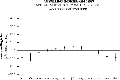 Figure 4: The annual cycle of upwelling and downwelling off of the WA coast using data from 1967 through 1991 (from NOAA’s Pacific Fisheries Environmental Lab).