The Arctic Oscillation and Pacific Northwest Weather
The Arctic Oscillation (AO), also known as the Northern Annular Mode (NAM), is an important element of the variability in the weather and climate of the Northern Hemisphere. It relates fundamentally to the state of the flow at northern latitudes, with the positive phase associated with a strong, axisymmetric polar vortex and the negative phase associated with a weak polar vortex, allowing for more prominent large-scale ridges and troughs for the whole hemisphere. The AO/NAM explains about one-third of the variance in the flow of the Northern Hemisphere in the lower stratosphere during winter, and about 20% of the variance in the troposphere. There was essentially a reawakening of interest in the AO/NAM by the climate community in the late 1990s in response to the work by Prof. Mike Wallace at the University of Washington and his student David Thompson (now a professor at Colorado State University); the importance of annular patterns in the atmospheric circulation was recognized by Sir Gilbert Walker and Carl-Gustav Rossby in the 1930s. But all this may seem a matter of academic interest, so why should the man in the street care about the AO?
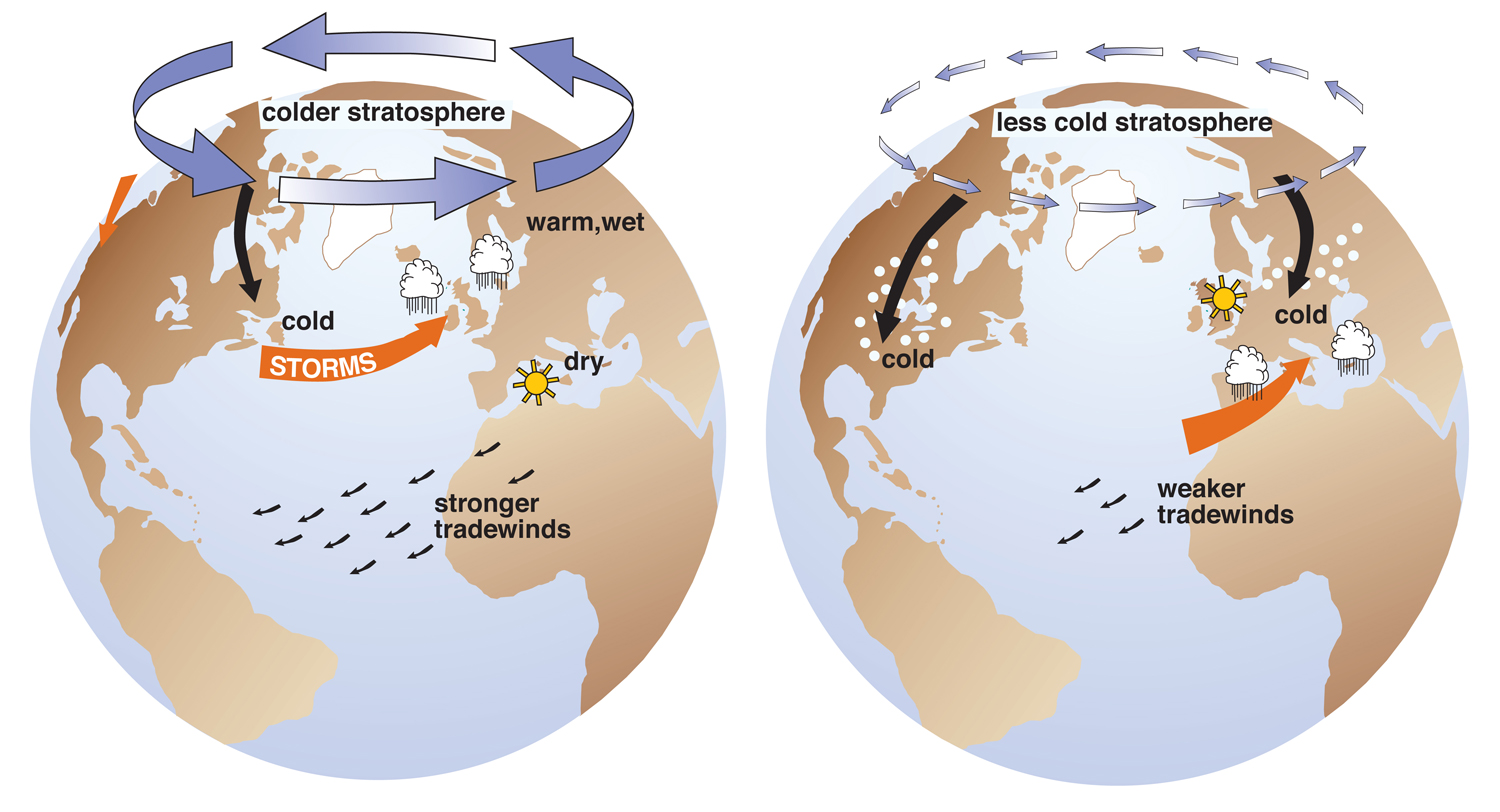
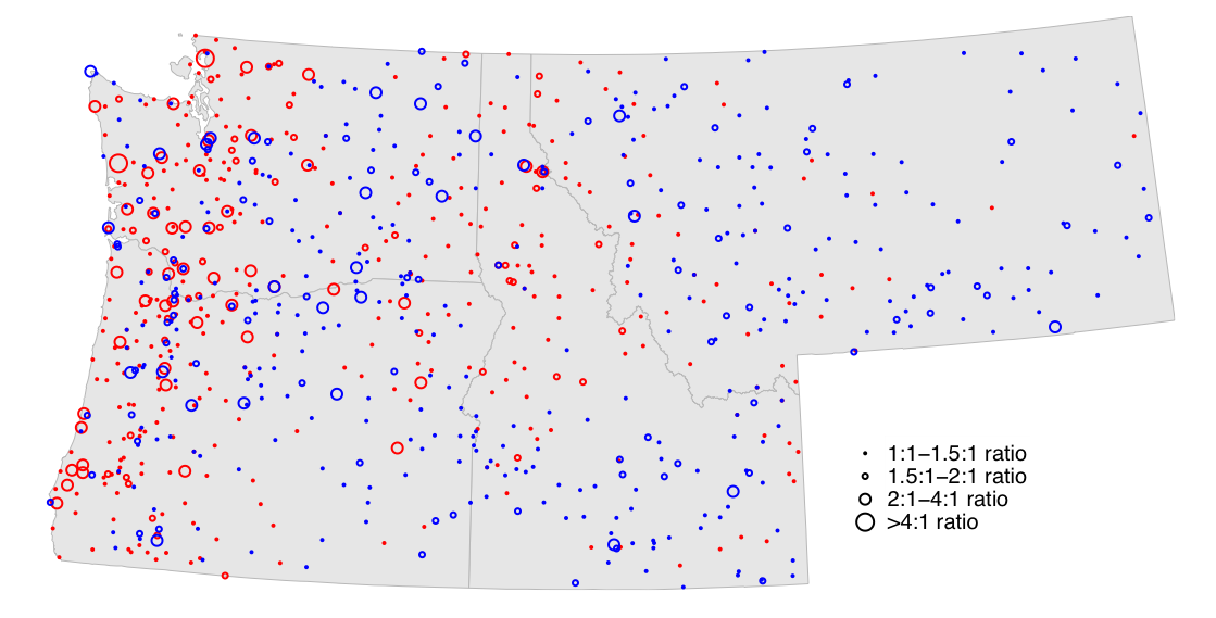
He should care about it because it often relates to the footing. As illustrated in Figure 1, frigid air of Arctic origin tends to remain bottled up at high latitudes during positive phases of the AO/NAM (left side), and cold-air outbreaks to the mid-latitudes are more likely and dramatic when the AO is in the negative phase (right side). The schematic in Figure 1 highlights the latter effect for the eastern US and Europe…what about our own neck of the woods? Thanks to the efforts of a former student of Mike Wallace, Greg Ostermeier, it is possible to check for oneself on the following website: http://research.jisao.washington.edu/greg/northwest/. Figures 2 and 3 have been lifted off this website and show the ratio of the occurrence of extreme Tmin and high precipitation days, respectively, during the positive phase of the AO/NAM versus the negative phase. Note that relatively cold temperatures are associated with a negative state for the AO/NAM in most, but by no means all, stations in Washington state (Figure 2). This signal is extremely strong in Montana, especially east of the continental divide and basically lacking across the southern portions of Oregon and Idaho. With regards to precipitation, extreme events on the west side of the crest of the Cascade Mountains of Washington and Oregon occur considerably more often during the positive phase of the AO/NAM, with most of the stations to the east including an opposite relationship, but with plenty of exceptions. Additional work (not shown on the aforementioned website) indicates that strong winds in the Puget Sound basin, and especially high waves on the WA coast are roughly 3 times more likely during positive relative to negative phases of the AO/NAM. These results make sense in that a high-amplitude ridge (block) must develop in the central North Pacific in order for our region to be blessed with cold northerly flow out of northwest Canada; a more zonal flow accompanies the landfall of Pacific storms bearing wind and heavy rain. It should be appreciated that the AO/NAM influences just the probability of various kinds of episodic weather events rather than serving as any sort of guarantee one way or another.
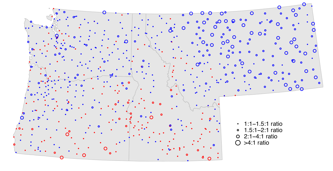
http://research.jisao.washington.edu/greg/northwest/TMIN/NAM/ for more examples.
The AO/NAM is receiving ongoing attention from the climate community. There would be substantial benefits from being able to predict it beyond the 1-2 week limits of numerical weather prediction (NWP) model simulations. Seasonal forecasts of the sort produced for El Niño-Southern Oscillation (ENSO) are not yet possible. Moreover, because the AO/NAM is a characteristic of the high-latitude atmospheric circulation, its long-range prediction will always be limited by the chaotic nature of this circulation and hence lack of predictability. That being said, there is tentative evidence that the sense of the AO/NAM tends to relate to the sense of the quasi-biennial oscillation (QBO) in the zonal winds of the tropical stratosphere through the former’s modulation of interactions between planetary waves and the mean flow. More controversially, it has been suggested that variations in surface conditions, specifically snow cover over Siberia, and in separate studies, sea ice in the Arctic, are linked to the AO/NAM. There may actually be enough lead time with these effects to stack the deck one way or another, if not assure, the overall sign for the AO/NAM during an upcoming winter. Finally, is global climate change liable to favor a positive or negative state to the AO/NAM? Without going into details, it is safe to say that no firm conclusions have been reached yet. In the meanwhile, the readers of this newsletter are encouraged to keep track of the short-term predictions of the AO/NAM available at a website maintained by NOAA’s Climate Prediction Center ( http://www.cpc.ncep.noaa.gov/products/precip/CWlink/daily_ao_index/ao.shtml ) and dream about what kinds of storms might be on the horizon.