By Nick Bond
A previous newsletter (Aug 2010) included a piece on why thunderstorms are rare in WA State when compared to other parts of the country. Thunderstorms are revisited here, with a focus on their occurrence during the cold season. We look into where they are relatively common and or rare across the state, and regional atmospheric variables associated with past cold season events.
Monthly values of thunderstorm frequencies at a variety of stations from a weather almanac published in 1987 are reproduced in Table 1. Mean values over last few decades certainly are different to an extent, but these previous results are likely still valid in general terms. These frequencies to the nearest whole number are also indicated on a website maintained by the Western Regional Climate Center (https://wrcc.dri.edu/Climate/comp_tables.php). Data are available for two coastal stations (there is more complete data for Astoria than for Hoquiam; please do not hold it against us that we are using a location in Oregon), three stations near Puget Sound, the mountain station of Stampede Pass, and three stations in eastern WA.
There exists a reasonably clear signal for the cold season months of November through February relative to the rest of the year. The coast gets relatively frequent events except during February, the Puget Sound region hears the roar of thunder occasionally but less often than other times of year, and the Cascades and eastern WA experience thunderstorms very rarely, especially compared with during summer. It may not be evident why the seasonality of thunderstorms differs so much, especially between the coast and Puget Sound region. Thus we thought it interesting to examine various weather parameters during past occurrences of thunderstorms.
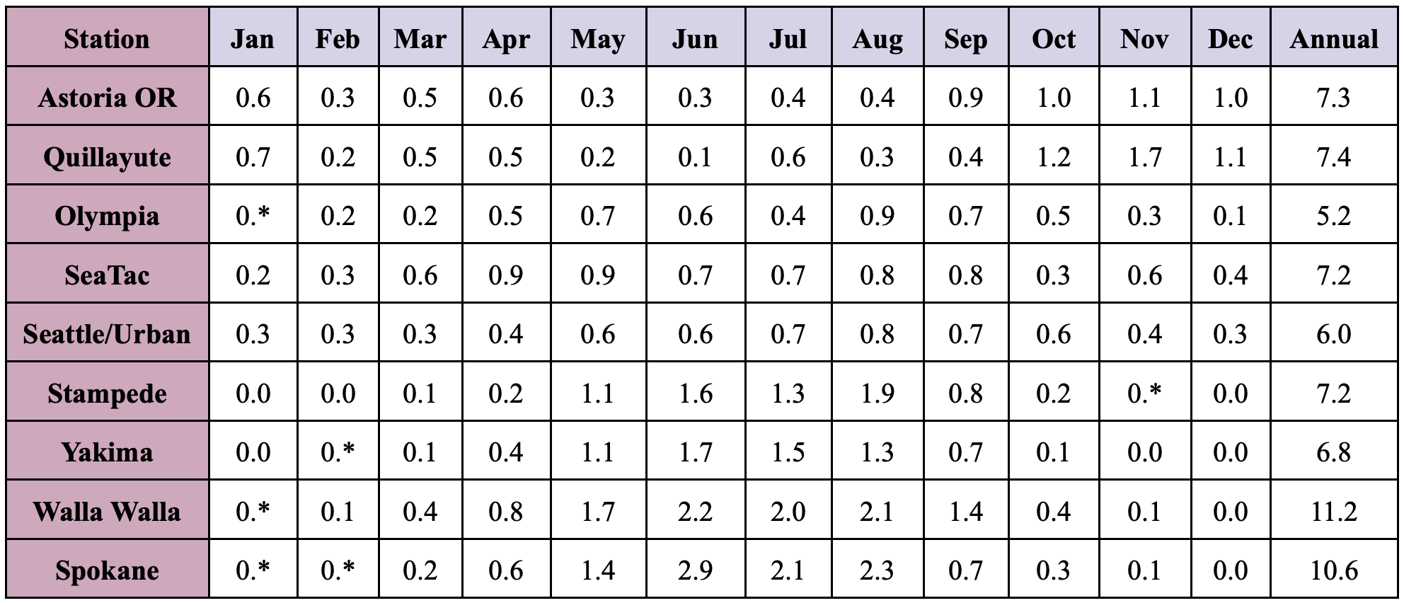 Table 1: Average number of thunderstorm days by month excerpted from Weather of US Cities, Vol. 2, 1987, J. Ruffner and F. Bair, eds. Station records for this tabulation range from 22 to 51 years in length. Entries of 0.* represent average values greater than zero, but less than 0.05.
We have examined regional weather maps for those days itemized in National Climatic Data Center (NCDC) Storm Events database as lightning or thunderstorm wind events in western WA during the months of November through February over the last 20 years. This listing served to be a convenient way to determine the timing of past events, but it should be realized that the listing is restricted to noteworthy incidents that caused damage or injury. The majority of these events (7 out of 9) featured impacts only in counties bordering Puget Sound, but the lack of an impact does not imply that lightning was absent elsewhere. We used 8 of these 9 events to make composite maps using the North American Regional Reanalysis (NARR) data product. The case of 9 November 1996 was excluded from this composite because it did not resemble the other cases at all, but instead something more akin to the typical scenario for thunderstorms during summer, specifically a high-amplitude ridge aloft over the western US.
On the other hand, the mean 500 hPa geopotential height pattern during the 8 winter thunderstorm outbreaks selected (Figure 1) features a prominent trough of lower heights offshore over the eastern North Pacific and indicates diffluent west-southwesterly flow over western WA. This pattern is conducive to substantial upward motion over western WA, as confirmed by the mean 700 hPa vertical velocities (not shown). We think that the regional distribution of convective available potential energy (CAPE; Figure 2) is quite interesting. Much higher values (greater static instability) were found over the ocean and the immediate vicinity of the coast than inland, even though the composite is based on times mostly featuring thunderstorms farther inland in locations near Puget Sound, at least in terms of impacts. The enhanced CAPE at the coast can be attributed to the higher surface air temperature and humidity over the water than land (not shown).
The presence of especially warm water in the NE Pacific at the time of this writing, affectionately known as the “blob”, may stack the deck for more convection than normal in western WA. We were surprised by the results described above. It was expected that the upper-level trough would tend to be more overhead, i.e. that thunderstorms would be associated with especially cold-air aloft, as is typically the case during spring. Instead, based on our admittedly simple analysis, deep and vigorous enough convection to promote the electrification of clouds may be more dependent on the forcing of strong upward motion, presumably as long as there at least modest instability.
It should be recognized that while the 8 cases in the composites shown here all resembled one another, there are other ways that deep convection can occur in WA state during the winter. Occasionally it appears to be cold enough aloft to support thunderstorms during wintry weather. A notable example is represented by the marvelous storm of 18 December 1990 when the central and northern portion of Seattle experienced a few claps of thunder during a short period of very heavy snowfall. More commonly, the Puget Sound Convergence Zone can support vigorous enough convection to generate some lightning, often accompanied by ice pellets or snow if temperatures are close enough to freezing.
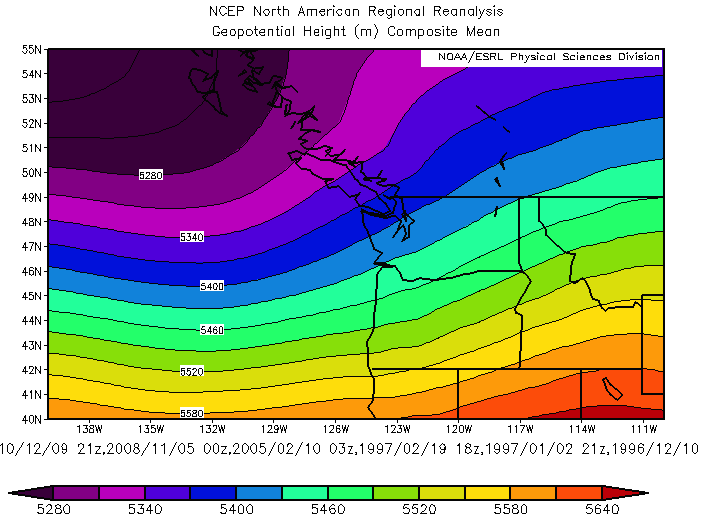 Figure 1: Composite 500 hPa geopotential height (m) for 8 thunderstorm events associated with damage or injury in western WA during the winter months of November through February.
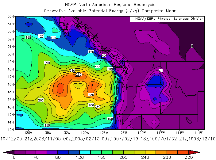 Figure 2: As in Figure 1, but for convective available potential energy (CAPE; J/kg).