By Nick Bond
As readers of this newsletter are aware, the tropical Pacific is currently in an El Niño state. Such conditions in the tropical Pacific have usually, but not always, been accompanied by relatively warm winters in the mean for the Pacific Northwest. El Niño winters also tend to be on the dry side, with plenty of exceptions. The mean seasonal weather is of interest and relevance, naturally, but short-term, episodic events are often just as or more important. Here we focus on a particular type of event related to El Niño that may not get much attention and that is coastal flooding. The objective of this piece is to illustrate the correspondence between past El Niño events and especially high sea level, and the implications for coastal flooding.
The present analysis is based on direct observations of sea level from tide gauges maintained by the National Oceanic and Atmospheric Administration (NOAA) for the period of January 1980 through August 2015. The specific parameter considered is the monthly mean higher high water (MHHW), which represents the average height of the highest tide each day in feet, and can relate to the potential for coastal flooding. Actual flooding generally requires the juxtaposition of a high astronomical tide, and a storm/wind induced rise in sea level. Relatively high astronomical tides are favored in winter, and January is usually the month of the year with the greatest MHHW for WA state.
A time series of MHHW for Toke Point, WA (#9440910) at the northwest end of Willapa Bay is shown in Figure 1. The months with MHHW greater than 1.5 feet are labeled; 4 out of 5 of these months are during El Niño winters. The maximum during the period was in January 1998, which coincides with the extreme El Niño of 1997-98. The magnitude of the El Niño signal might be greater than would be supposed. Specifically, El Niño elevates MHHW by on the order of 0.5 to 1 foot, an effect that is sufficient to cause a significantly greater threat of flooding in sensitive locations.
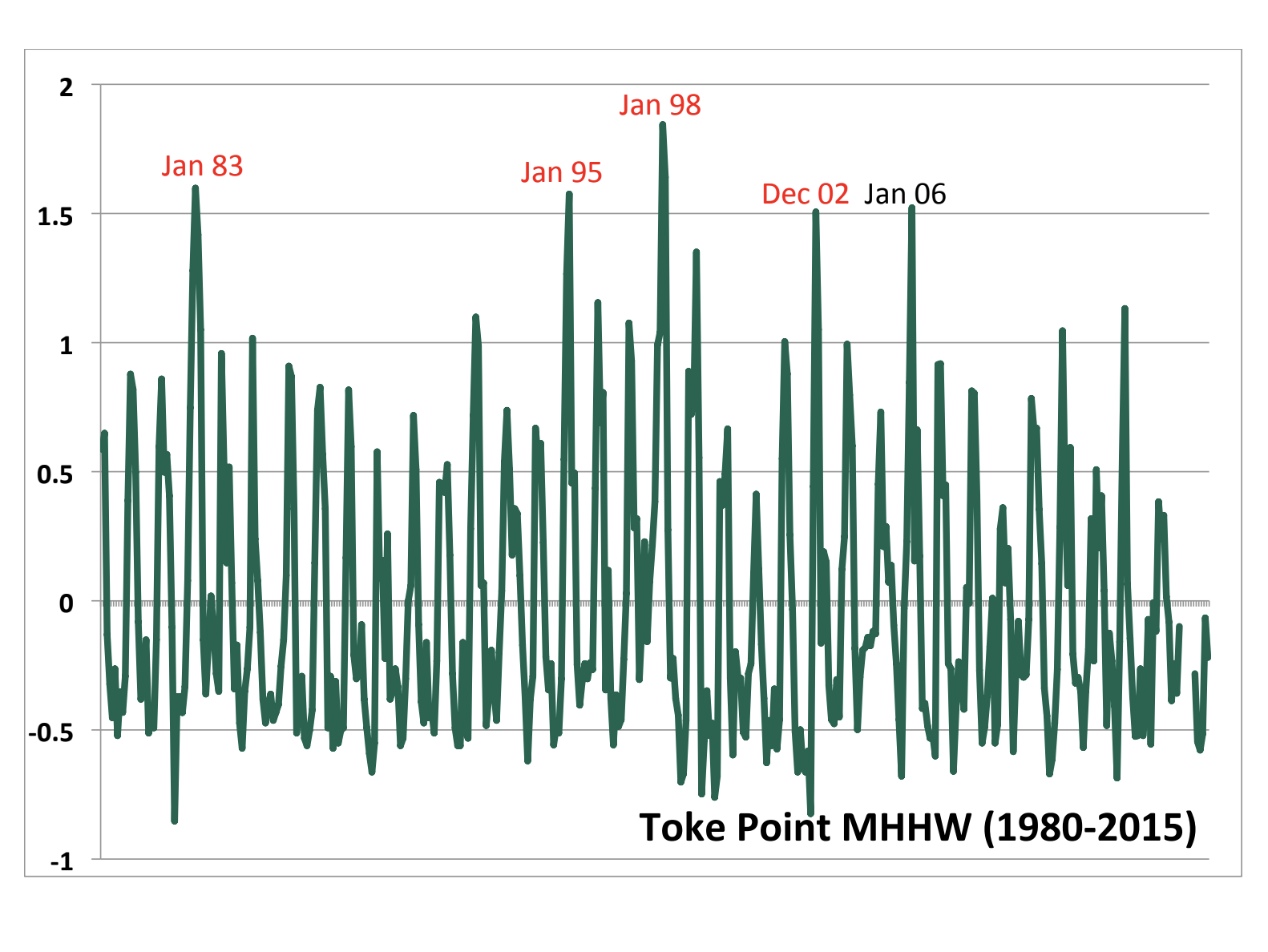 Figure 1: Monthly higher high water (MHHW) in feet at Toke Point, WA for January 1980 through August 2015. The months with MHHW exceeding 1.5 feet are noted; red (black) labels indicate El Niño (neutral) conditions.
Elevated sea levels during El Niño are not restricted to the coastal zone but rather also occur in the interior waters of Puget Sound. A scatter plot for the MHHW at Toke Point versus Seattle (Fig. 2) features a strong positive correspondence; the correlation coefficient between the two time series is ~0.84. In other words, perturbations in coastal sea level are also manifested in the inland waters, through a complicated adjustment process outside the scope of the present piece.
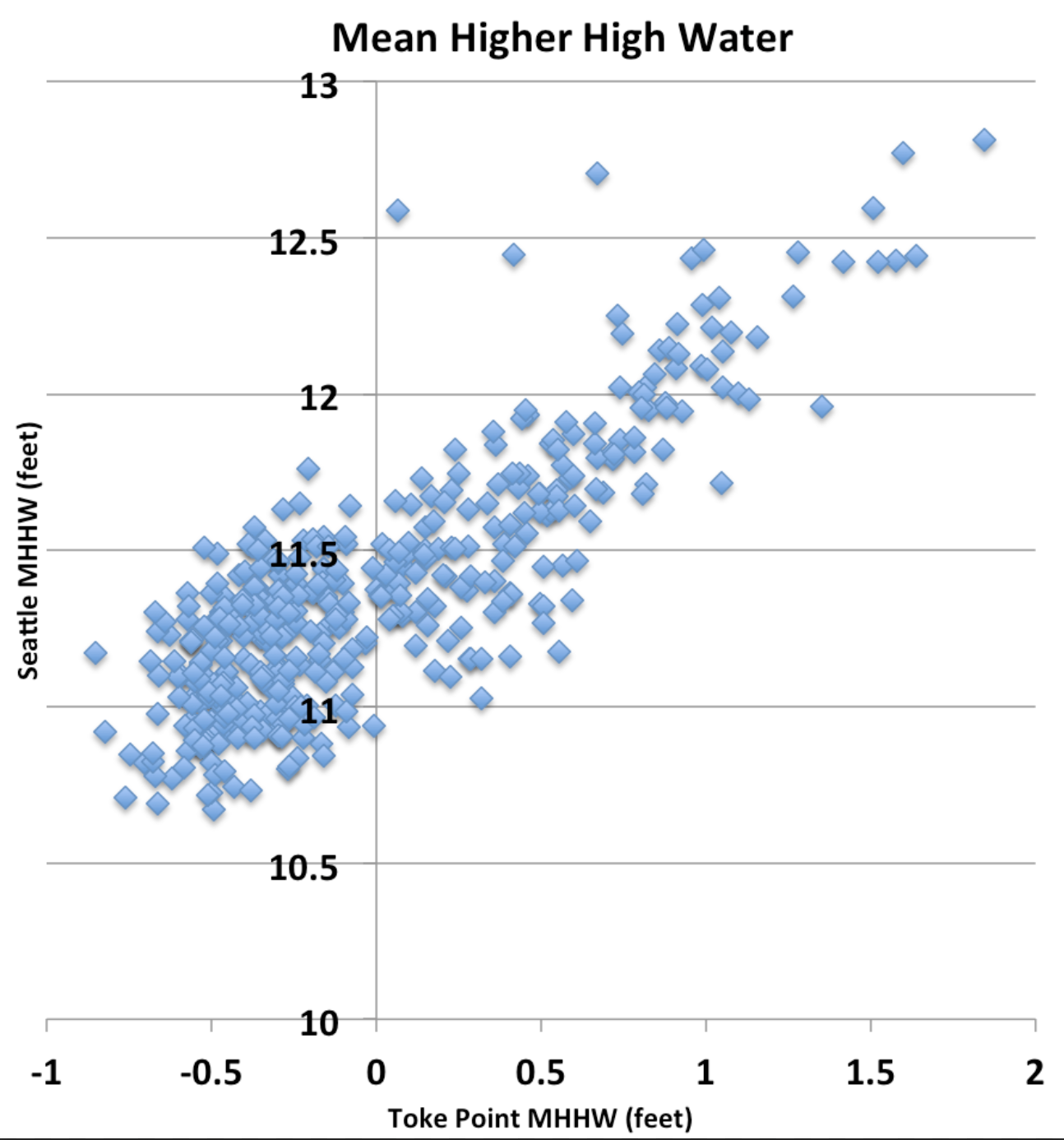 Figure 2: Scatter plot of MHHW (feet) at Toke Point (x-axis) versus Seattle (y-axis) for the period of January 1980 through August 2015.
How does El Niño influence sea level along the coast of the Pacific Northwest? There are four potential (not completely independent) mechanisms: (1) the inverse barometer effect (i.e., negative sea level pressure anomalies raise ocean levels), (2) the steric effect associated with the expansion of warmer than normal water, (3) regional winds and hence onshore-directed upper-ocean transports, and (4) coastally-trapped oceanic disturbances (e.g., Kelvin waves) due to remote forcing. For the coastal region of WA generally (3) dominates, with contributions from (2) and (4). The southerly wind anomalies that occur during most El Niño winters are accompanied by onshore-directed Ekman transports, with variability within the winter season due to the non-steady nature of the winds. A schematic illustrating this mechanism is included in Fig. 3. For orientation with respect to the present application, imagine you are hovering over the ocean west of the WA coast, looking towards the southeast. Bromisrski et al. (2011) provide more information about the processes controlling sea level along the west coast of the US, and their relationships to climate fluctuations such as the Pacific Decadal Oscillation (PDO).
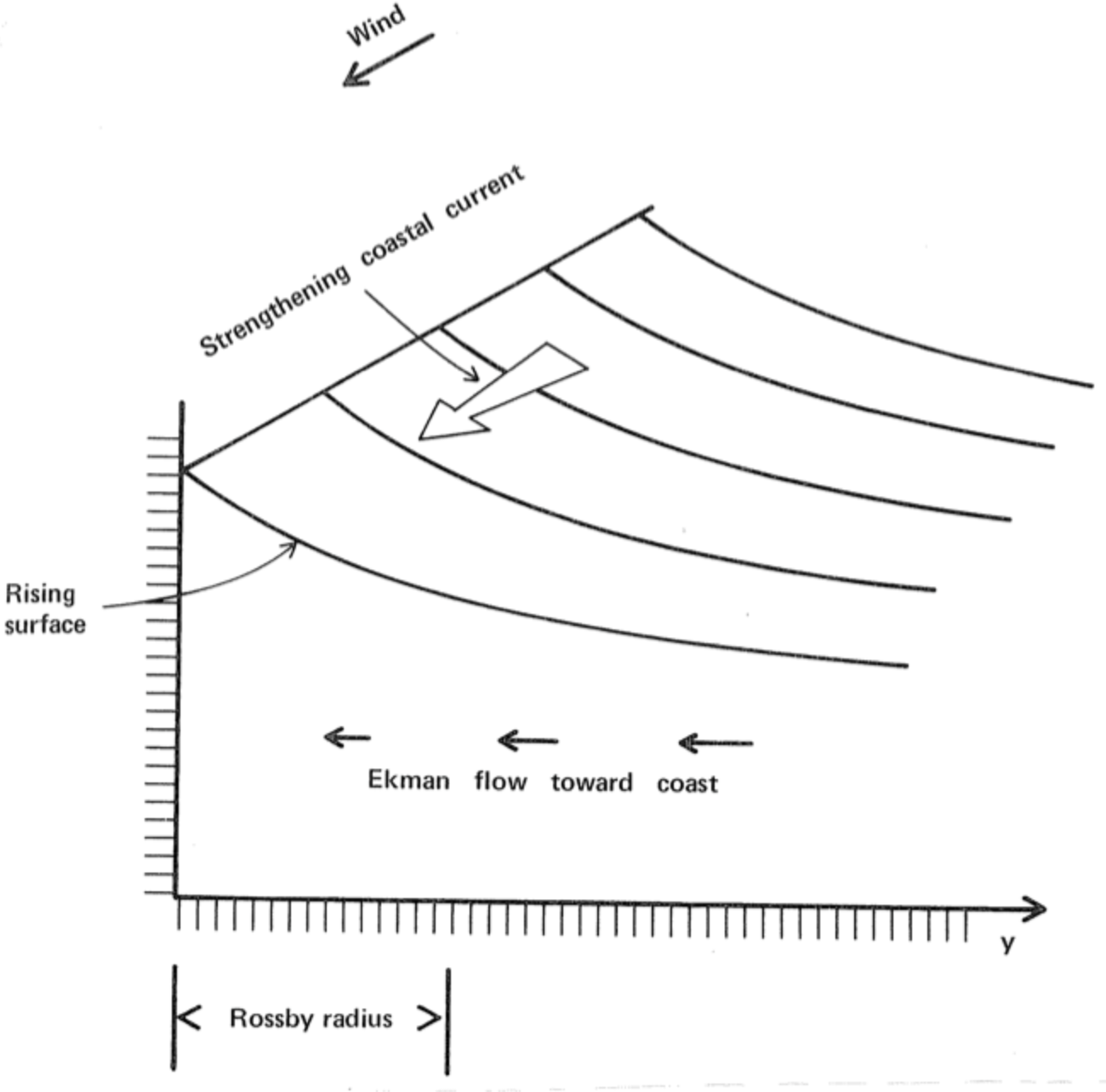 Figure 3: Schematic illustrating the effects of along-shore winds on coastal sea level in the Northern Hemisphere (excerpted from Gill, A.E.: Atmosphere-Ocean Dynamics, Academic Press, 1982)
In summary, we can expect a relatively high mean sea level this winter due to El Niño. As mentioned above, it is a matter of chance whether this results in any major inundations, or rather merely the nuisance of minor flooding at times. To put it in perspective, the magnitude of the temporary rise in sea level that will probably occur this winter is comparable to the systematic rise in sea level projected to occur in our waters by roughly the middle of the 21st century due to global climate change.
Reference:
Bromirski, P.D., A.J. Miller, R.E. Flick, and G. Auad (2011). Dynamical suppression of SLR along the Pacific coast of North America: Indications for imminent acceleration, J. Geophys. Res. – Oceans, 116, C07005, doi:10.1029/2010JC006759.