By Nick Bond
Most everyone in the Puget Sound region on 23 December 2022 must have been impressed by the freezing rain that occurred that day. This event featured extremely slippery roadways and outside walkways; at least no one we have spoken with recalls a time when it was more treacherous to get around. Our objective here is to provide a bit of climate context for this event based on previously published work.
Before we get started, let’s briefly review the situation on 23 December. Without going into all the gory details, freezing rain requires cold, sub- freezing air near the surface overlaid by warm air in the presence of precipitation, of course. Surface air temperatures were generally in the middle to upper 20s (°F) during the late night and early morning of 23 December 2022, and there was definitely warm air aloft, with the 12 UTC (4 AM local) weather balloon sounding from Salem, OR indicating a temperature of 5.0°C (41°F) and southwest winds of 45 knots at the 850 hPa level (about 4800 feet above ground level). The overall magnitude of the inversion in this sounding was an impressive 14°C. The cold air at the surface was maintained by easterly cross-Cascade mountain flow, with temperatures along the east flank of the Cascades mostly in the single digits. The precipitation that occurred that morning fell on a surfaces ranging from bare to scant amounts of packed down snow, resulting in essentially sheets of ice. Previous events have often occurred when there has been more snow on the ground, and again based on personal experience, with less dire consequences. At least that was the case during the 19 January 2012 event in the Puget Sound basin, which actually included mostly greater precipitation amounts both prior to and during the interval with freezing rain, but a somewhat different regional weather pattern that included not as frigid air east of the Cascades and not as warm air aloft. Freezing rain was also reported in the southern portion of Puget Sound during late December 1996 after a period of substantial snowfall in the transition to warmer temperatures and heavy rain. The freezing rain in these situations occurred in western Washington, but certainly eastern Washington gets its share, as will be elaborated upon below. From an event perspective the year of 2017 stands out, during which eastern Washington experienced significant ice storms in January, February and December, as described in the NOAA Storm Events Database.
There has been past work on the distributions of the historical mean in the frequency of freezing rain, and changes over time in these frequencies. With regards to the former, we reproduce a map (Fig. 1) from the review of ice storms by Degelia et al. (2016), which itself was lifted from Chagnon and Karl (2003). Figure 1 shows the average annual number of days with freezing rain for the years of 1948 through 2000, and so is somewhat out of date. That being said, presumably the overall patterns shown are reasonably valid. Some readers may be surprised by the local maximum in frequency in the Columbia Basin of eastern WA. But the residents of that region are liable to be OK with this portrayal in that the “cold pool” that often settles into this lower-elevation region (Whiteman et al. 2001) can be accompanied by relatively warm air aloft with stratus cloud decks thick enough to produce freezing precipitation. This precipitation is more often in the form of small drizzle droplets (or small ice pellets) versus rain; we wonder whether this distinction is captured in the records used by Changnon and Karl (2003) that rely on manual observations. The map in Figure 1 also is just a crude representation of known spatial variations in the incidence of freezing rain. In particular, it is well-known that the Columbia River gorge is prone to ice storms, and there is barely a hint of such a feature. The Cascade Mountain passes also experience frequent, and also highly consequential, bouts of freezing rain. But an important takeaway is that eastern WA state and northern OR experience freezing rain relatively often compared to the rest of the western US.
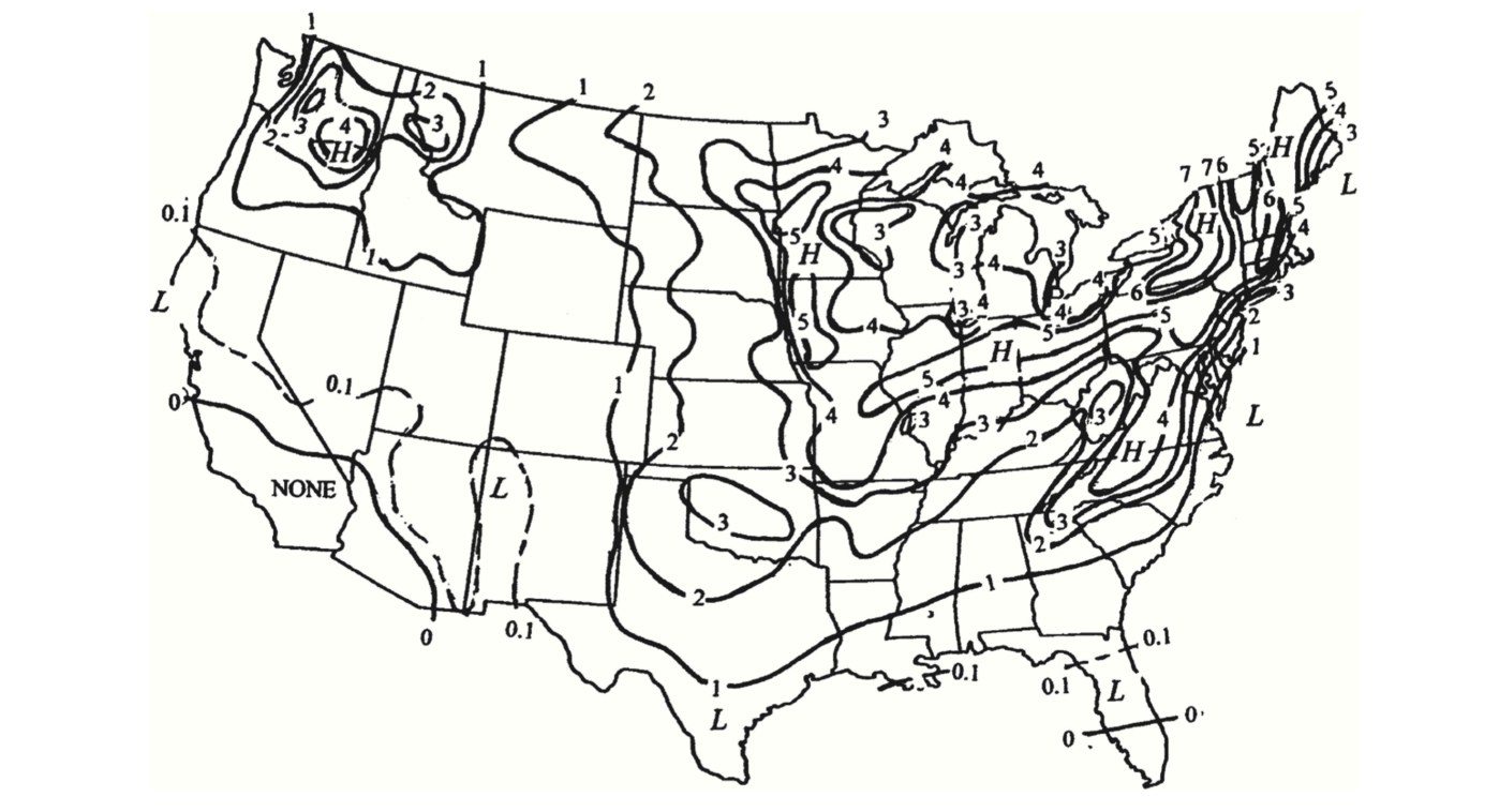 Figure 1: Figure 6: Average annual number of days with freezing rain from 1948-2000 (from Degelia et al. 2016 and Chagnon and Karl 2003).
A study of the trends in freezing rain frequency has been carried out by Groisman et al. (2016). Shown here as Figure 2 is a map for the US indicating changes in the number of days per year in freezing rain between the decade of 2005-2014 and the previous 3 decades of 1975-2004. For events as rare as freezing rain, especially in some parts of the US including western WA, a period of 10 years is a short interval to construct meaningful averages. We also wonder how much of a problem, i.e., the errors introduced in comparing present to past frequencies, relates to the change from manual to automatic observations. At any rate, their analysis shows that the northwestern portion of WA underwent an increase in frequency in these events, while most stations considered in the interior of the Pacific NW indicate a decrease in frequency. It is unclear to us how the frequency of freezing rain is liable to evolve in association with global warming. Conceivably the trends will play out differently for the west side of the Cascades where surface temperatures in the lowlands tend to be above freezing and freezing temperatures become that much less common versus the east side. Eastern Washington surface temperatures during winter tend to be cooler, of course, and may be below the freezing point consistently enough such that changes in frequency will be minimal, or even increase if air temperatures aloft warm above freezing more often, while accompanied by precipitation, during those chilly situations.
 Figure 2: Figure 2: Changes in the number of days of freezing rain per year between 2005-2014 and 1975-2004 (from Groisman et al. 2016).
References
Changnon, S.A., and T.R. Karl (2003): Temporal and spatial variations of freezing rain in the contiguous United States: 1948-2000. J. Appl. M eteorol., 42, 1302-1315, doi:10.1175/1520-0450
Degelia, S. K., J.I. Christian, J.B. Basara, T. J. Mitchell, D.F. Gardner, and S.E. Jackson (2015): An overview of ice storms and their impact in the United States. Intl. J. Climatol., 36(8), 2811–2822, doi:10.1002/joc.4525
Groisman, P.Y, O.N. Bulygina, X. Yin, R.S. Vose, S.K. Gulev, I. Hanssen-Bauer, and E. Forland (2016): Recent changes in the frequency of freezing precipitation in North America and Northern Eurasia. Environ. R es. Lett., 11, doi:10.1088/1748-9326/11/4/045007.
Whiteman, C.D., S. Zhong, W.J. Shaw, J.M. Hubbe, X. Bian, and J. Mittelstadt (2001): Cold pools in the Columbia Basin. W ea. Forecast., 16, 432-447, doi:10.1175/1520-0434(2001)016