By Jacob Genuise
Precipitation anomalies were largely above normal across the state this March. The largest wet anomalies were across the Olympic Peninsula, the western side of the Cascades and near Mt. Baker, the Columbia Gorge, and across portions of far northern and northeastern Washington. March 2025 ranked as the 28th wettest since 1895. March 2025 was also the wettest March since 2017 and broke a multi-year stretch of drier-than-normal Marches from 2018-2024.
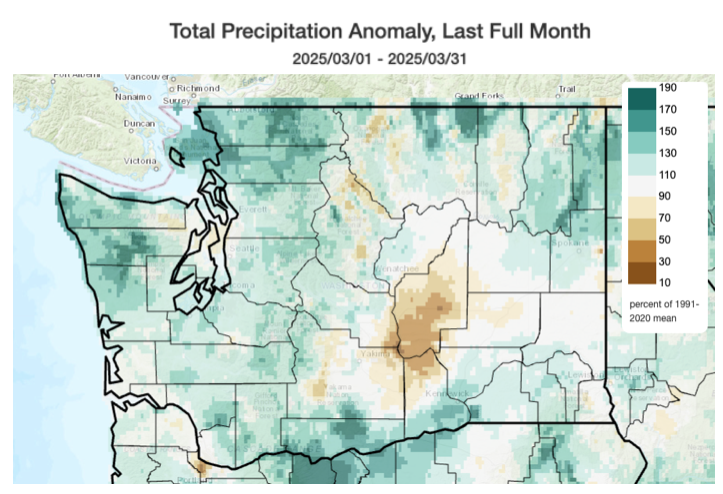 Precipitation anomalies as a percent of 1991-2020 mean precipitation for March 2025. Source: Climate Toolbox-Climate Mapper.
Most stations in western Washington recorded around 100-120% of normal precipitation. Across eastern Washington, Wenatchee, Pullman, Omak, and Pasco all recorded above normal precipitation as well. Stations around the Spokane Metro recorded slightly below normal precipitation. However, modeled precipitation anomalies (see map) show slightly above normal precipitation. We tend to trust the agreement amongst surface-based stations, but we are looking into this discrepancy.
There is also a notable region of well-below normal precipitation centered around the Columbia River near Mattawa/Desert Aire where both station-based measurements and modeled precipitation show only 30-40% of normal precipitation. Snowfall was also lackluster for the month in the lowlands with no snow beyond isolated trace amounts in the western Washington lowlands and only 0.4” recorded in Spokane (compared to a March average of 3.9” in Spokane).
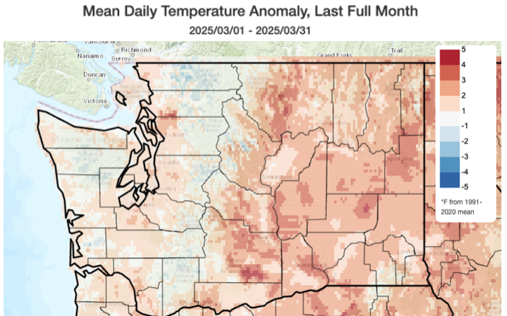 Temperature anomalies as a percent of 1991-2020 mean temperatures for March 2025. Source: Climate Toolbox-Climate Mapper.
Temperatures were above normal for the vast majority of the state, with anomalies of around 1-2°F above normal across western Washington and around 2-4°F above normal across eastern Washington. This includes a +3.5°F anomaly in Spokane and a +3.2°F anomaly in Pasco, as is shown in the table below. Statewide, temperatures were +1.9°F above the 1991-2020 normal, and March 2025 ranked the 20th warmest March since 1895. The warm spell in late March played a large role in these warm anomalies, as much of the rest of the month featured near normal or only slightly above normal temperatures at most stations.
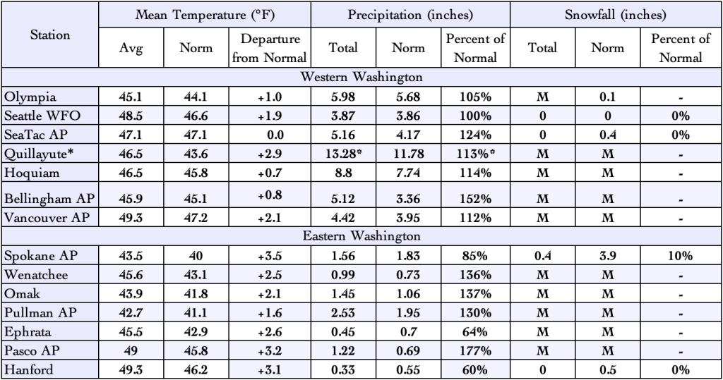 March 2025 climate summaries for locations around Washington with a climate normal baseline of 1991-2020. M denotes missing data. *Quillayute is missing 5 days of precipitation data. True precipitation for this site is likely greater than what is shown here.