By Jacob Genuise
In this edition of Climate Matters, we return to our Climate Division series in which we describe the local climate features in each of Washington’s 10 climate divisions, as defined by NOAA. In this installment, we will detail the climate of Washington Climate Division 9, ‘Northeast.’ To read about the other climate divisions in the state, please visit Washington’s Climate page.
Climate Division 9 encompasses the northeastern corner of Washington. This division includes the Spokane Metropolitan area, home to around 600,000 people, as well as the communities of Chewelah, Newport, Colville, and Republic. The reservations of the Kalispel, Spokane, and Colville Tribes are also located within this Division. This region has complex, mountainous terrain with a wide elevation range from around 1,500-2,000’ on the Columbia Plateau near Spokane and along the Spokane River up to 7,000’+ in the highest peaks Selkirk and Kettle ranges in the northern half of the region. This complex terrain contributes to a wide range of climatic conditions as well as localized microclimates. Precipitation is considerably higher in the higher elevations of this region, which receive around 40-50” of rainfall annually while areas on the Plateau receive around 15-20” per year.
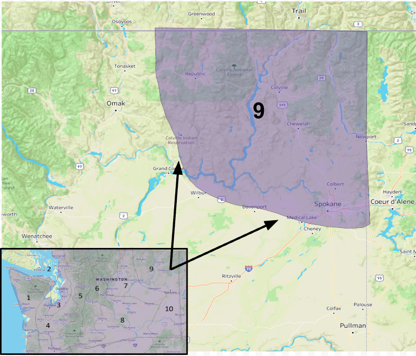 Climate Division 9: ‘Northeast,’ overlaid onto a topographical map.
This graph, known as a climograph, depicts monthly average precipitation and minimum and maximum temperatures, averaged over the entire climate division area from 1991-2020. Like the rest of the state, precipitation is most abundant during the cool season with November through January representing the wettest months of the year. In western Washington, precipitation steadily declines through spring as more frequent high pressure over the region tends to send storms further northward. However, northeastern Washington receives more spring precipitation as moisture is occasionally brought up from the interior United States in late Spring. This springtime pattern is more characteristic of the northern Rocky Mountain region of the United States where May and June tend to be the wettest months. We can see this pattern in Climate Division 9’s climograph because precipitation in March through June remains relatively steady. As is characteristic for the rest of the state, precipitation then drops off considerably from July-September when high pressure tends to dominate our region.
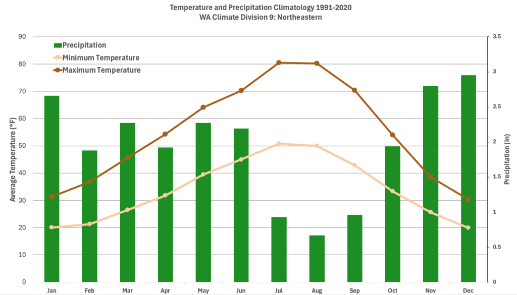 Climograph of monthly average minimum temperature, maximum temperature, and precipitation for Climate Division 9.
Despite these generally dry summers, strong summertime surface heating combined with complex terrain can create convective showers and thunderstorms that bring localized heavier precipitation. As a result, this corner of the state is among the most lightning-prone in the state. These lightning strikes can also serve as ignition points for wildfires in the region. Although severe weather is rare, thunderstorms have produced pocket change sized hail and damaging winds in the region. On June 5th, 2005 thunderstorms produced a gust to 77 mph in Spokane and numerous gusts above 50 mph.
 A table, courtesy of the NWS Spokane
Office, showing the highest gusts recorded from a thunderstorm complex on June 5th, 2005.
In the summer, temperatures can get quite warm in the lower elevations in the region, often reaching into the 90s and above 100°F in Spokane around once or twice per year in the present climate. In the winter, the Columbia Plateau and mountain valleys within this division are notorious for persistent fog. This fog can stick around for days and even weeks on end, only lifting briefly in the afternoons. When temperatures drop below freezing, fog can freeze on surfaces and cause travel disruptions region-wide. Non-thunderstorm winds can also be strong across the Plateau, mainly in the cool season when the cold fronts that often drive these strong winds are more common. These winds are also prone to the effects of the terrain. In particular, during many cold-air outbreaks the low-level flow accelerates down the Purcell Trench, a north-south oriented valley from Canada to about Coeur D’Alene, Idaho that then turns towards Spokane. Spokane Valley represents the exit of this gap, resulting in locally-enhanced wind speeds.
The warmest month since 1895 in Climate Division 9 occurred in July 2021 with a monthly average temperature of 72°F, +7.7°F above normal. Spokane International Airport, one of the oldest continuous climate stations in the state, also set the record for the most number of days above 90°F in a single July (22 days) in July 2021. The coldest month since 1895 for Climate Division 9 was January 1937 when the average temperature was just 3.9°F for the month. This was an impressive anomaly of 17.9°F below normal, and Spokane Airport set a January record of 23 days in which the maximum daytime temperature was below 20°F.
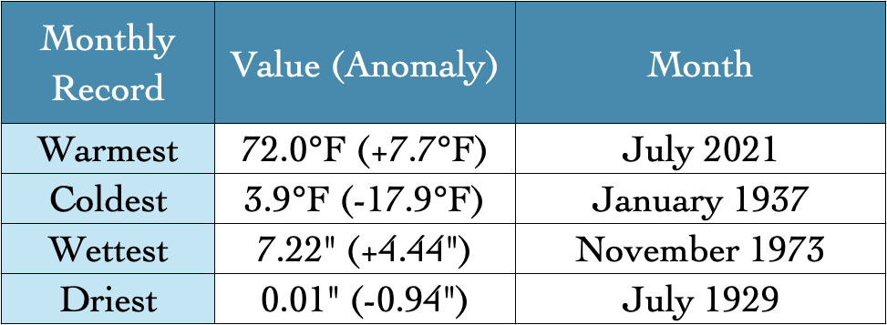 Table of the warmest, coldest, wettest, and driest month on record from 1895-2024.
The wettest month on record occurred in November 1973 with an average of 7.22” of rainfall across the division. The driest month on record occurred in July of 1929 when an average of only 0.01” of rainfall fell. July 1929 was a particularly dry year across the western and central United States and is often noted as the beginning of the 1930s United States dust bowl in the central and southern plains.
This division has also seen a steady warming trend since 1895. Temperatures have risen at a rate of about 1.5°F per century during this time period which is just below the statewide rate of about 1.7°F per century over this same period.
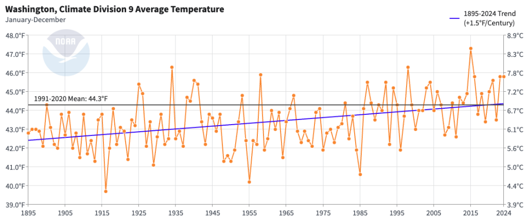 Graph of Average Annual Temperatures in Climate Division 9 from 1895-2024.
There is also a slight increase in annual precipitation since 1895, but this trend is not statistically significant. This slight trend is also likely affected by variations that are not related to climate change, such as the notable dry period in the 1910s through the 1930s. This is a good reminder that in this climate division as well as in much of the rest of the state, year-to-year variability in annual precipitation remains larger than long term changes in annual precipitation due to climate change.
 Graph of Average Total Precipitation in Climate Division 9 from 1895-2024.
In summary, Washington’s Northeastern Climate Division has a more continental climate typical of eastern Washington, with hot summers and cold winters. Echoing the pattern in the Rocky Mountain foothills, it has wetter springs than western Washington, but dry summers as in the rest of the state. This Climate Division’s complex topography also leads to large variations in temperature and precipitation as well as unique climate features. North-south oriented valleys allow for cold air to filter in from Canada and the interior Rockies in the winter, and fog is often persistent and dense during winter in the mountain valleys and Columbia Plateau.
Do you have feedback on our Climate Division series? Contact us or follow us on X or Bluesky.