By Jacob Genuise
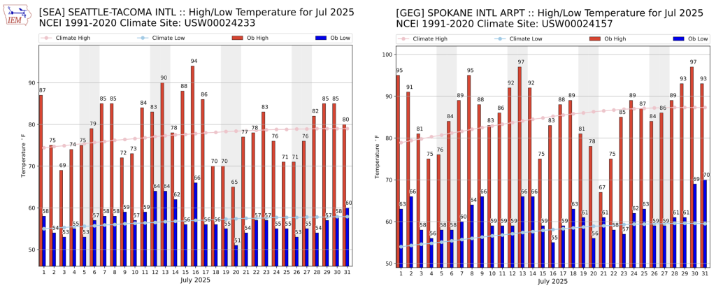 July 2025 daily high (red bars) and low (blue bars) temperatures as well as normal high and low (pink and light blue lines, respectively) for SeaTac Airport (left) and Spokane (right). Gray shading denotes weekends.
July brought frequent warm spells across the state. In western Washington, July 16 brought the hottest temperatures of the season so far for most. On this day, SeaTac reached a high temperature of 94°F, and Seattle Sand Point WFO reached 95°F, breaking the previous daily record at Sand Point of 89°F set on July 16, 2018. Quillayute also set a daily high temperature record on July 15 with a high temperature of 90 °F. Temperatures soared into the upper 90s in the Nisqually Delta and south toward Longview and Vancouver, WA as well.
A relatively cool spell, as seen in the above daily temperature graph for Seattle (left) from July 17-27, was caused by near daily pushes of cool and moist air from the Pacific Coast into much of western Washington. Morning fog and low clouds were a consistent feature during this period, often clearing for inland areas by midday or early afternoon each day.
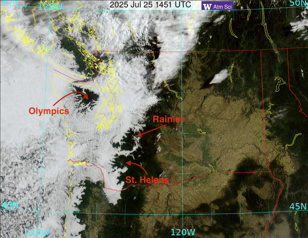 GOES Satellite imagery from July 25, 2025 at 7:51am PDT.
What causes this persistent layer of summer gloom, you might ask? Light southwesterly flow brought the marine layer and associated low clouds far into the interior of Western Washington. Satellite imagery from the morning of July 25 shows this coastal air clearly as low clouds settle into the Puget Sound lowlands and into the valleys of the Olympics and Cascades.
This layer is often relatively shallow, so our mountains put on quite the show as they peek out above the cloud layer. Take a hike above this cloud layer and you’ll be rewarded with a sunny view of the cloud layer from above.
On the morning of July 25, the marine layer was thick enough to bring mist and drizzle to Puget Sound. This humble drizzle served as the only measurable precipitation for the month for many locations; only around 0.01”-0.03” according to CoCoRaHS observations and did little to moisten soils.
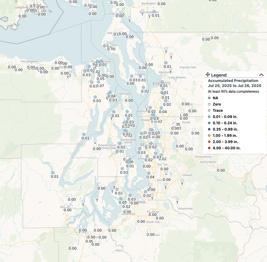 Precipitation observations around Puget Sound from the morning of July 25, 2025 due to marine layer drizzle. Data from CoCoRaHS and observers like you!
Across eastern Washington, which lacked the influence of a marine layer with low clouds, temperatures ran more consistently above normal with many locations observing temperatures around 2-4°F above normal. In the higher terrain of the Cascades, Okanogans, and Rockies, a more active period of instability during the latter third of the month brought repeat summertime thunderstorms and scattered beneficial rainfall along with the threat for lightning-induced fires. In particular, the afternoon and evening hours of July 21 and 22, two separate thunderstorm complexes brought rainfall to the North Cascades. Isolated and mainly dry thunderstorms then put on a show across northeastern Washington again on July 27 bringing a few tenths of an inch of precipitation to the outskirts of the Spokane metro. Storms returned on July 30 and 31 prompting flash flood watches from the NWS due to the threat for slow moving thunderstorms. Thankfully no significant flooding occurred.
Although storms brought pockets of precipitation here and there, the most notable feature was actually a persistent lack of precipitation with most locations from the Puget Sound south toward Vancouver and much of the Columbia Basin recording well below normal precipitation for the month. Learn more in the statewide July 2025 Climate Summary.
The Bear Gulch fire began near Lake Cushman on July 6 and then experienced rapid growth on the evening of July 29th. The fire grew to 5,126 acres by August 6th with containment of only 3%. Smoke and poor air quality impacts were felt across western Washington on August 4th as a result of this fire growth. The fire is believed to be human caused and has prompted road closures for a portion of FS-24 and nearby trailheads and campgrounds. Visit the Northwest Interagency Coordination Center for the most recent updates and information on this and other fires across the state. As fire season ramps up, stay up to date on burn restrictions and information on outdoor air quality.