By Jacob Genuise
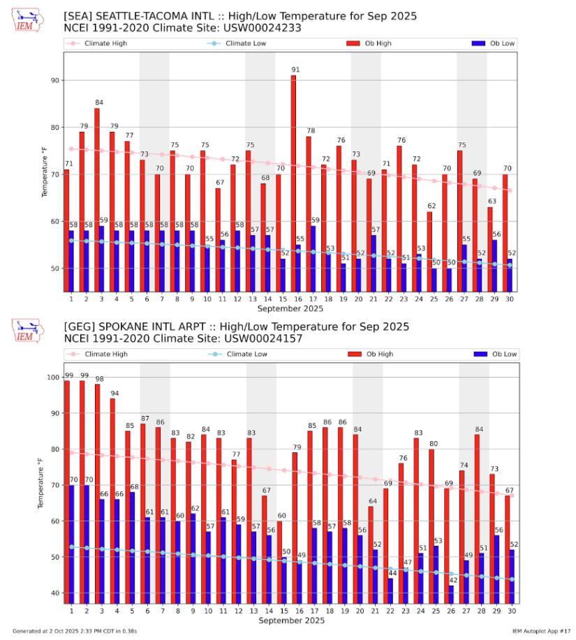 September 2025 daily high (red bars) and low (blue bars) temperatures as well as normal high and low (pink and light blue lines, respectively) for SeaTac Airport (top) and Spokane (bottom). Gray shading denotes weekends. Normals are based on the period 1991-2020.
September was once again a warmer than average month statewide. This was especially true across eastern Washington where prolonged warm spells with particularly warm overnight temperatures led to anomalies of around 5-8°F above normal.
In western Washington, a brief single-day heat wave occurred on the 16th as a strong ridge built over the region. This warm day is clearly visible as a mid-month spike on the above graph of SeaTac’s daily temperatures. SeaTac’s high temperature of 91°F on the 16th tied the daily high record set on the same day in 1967. Seattle Sand Point reached 92°F and smashed the previous 79°F set in 1994 (records at Sand Point only go back to 1987). Quillayute reached 85°F (prev. 84°F in 1991) and Bellingham reached 85°F (prev. 82°F in 1967) setting new daily high temperature records in the process. Vancouver, WA’s high of 90°F tied the daily record from 2023.
A cold front brought temperatures back down to near normal overnight into the 17th. This late season warmth is very likely to be the last day above 90°F for the season in western Washington and possibly statewide. SeaTac’s latest 90°F day on record is September 22 (1960), Spokane’s latest 90°F day on record is September 27 (2022), and the Tri Cities’s latest 90°F day on record is October 6 (2020). We aren’t likely to see another 90°F day until May or early June (in eastern Washington) and June or July in western Washington.
Perhaps the most notable and impactful weather-related event in September was related to fire activity and the associated statewide smoke impacts. A dry start to the month and periods of gusty winds, especially in the eastern slopes of the Cascades, allowed existing wildfires to expand.
The Bear Gulch fire in the Olympics expanded rapidly on September 16th and 17th due to gusty dry winds and very dry fuels. While fires are a natural process statewide, even in the relatively wet Olympics, it is very unusual to have a fire of this size in the Peninsula. The vast majority of fires in the Olympics remain under 1,000 acres.
At 20,000 acres as of October 1, the Bear Gulch Fire is the largest fire since the 1951 Great Forks Fire which burned 38,000 acres. Learn more about notable fires near Olympic National Park from the National Parks Service.
Shifting focus to the east side of the Cascades, the Lower Sugarloaf Fire (north of Wenatchee and Leavenworth) is the largest fire in the state burning 39,594 acres as of October 1, followed closely by the Labor Mountain Fire just to the south which has burned 37,239 acres as of October 1. Further south near Rainier, the smaller Wildcat Fire stands at 14,333 acres as of October 1.
These fires led to prolonged smoke exposure across eastern Washington as well as some brief periods of smoke exposure across western Washington during easterly offshore wind events. On Sept 5th, a small, concentrated plume of smoke from the Wildcat Fire near Mt. Rainier produced some of the worst air quality observed in the north Seattle metro area in several years. Then on September 20-23 smoke returned to western Washington and Puget Sound as easterly winds brought more smoke in from eastern Washington down through the Cascades valleys, as seen on satellite imagery.
 Satellite imagery of Washington on the morning of September 20, 2025.
Across eastern Washington, smoke-related air quality and visibility issues were much more persistent and impactful to human health. Plots of daily PM 2.5 levels, in Spokane and Wenatchee for 2025 reveal just how poor September’s air quality was compared to the rest of the year. In Spokane, persistently poor air quality was also present earlier in the year (January and February) due to wintertime inversions trapping pollutants near the ground, but wildfire-related air quality in September was much more severe and persistent. The town of Wenatchee sits generally downwind of two of the largest wildfires currently burning in the state, and has been particularly hard hit by smoke this year.
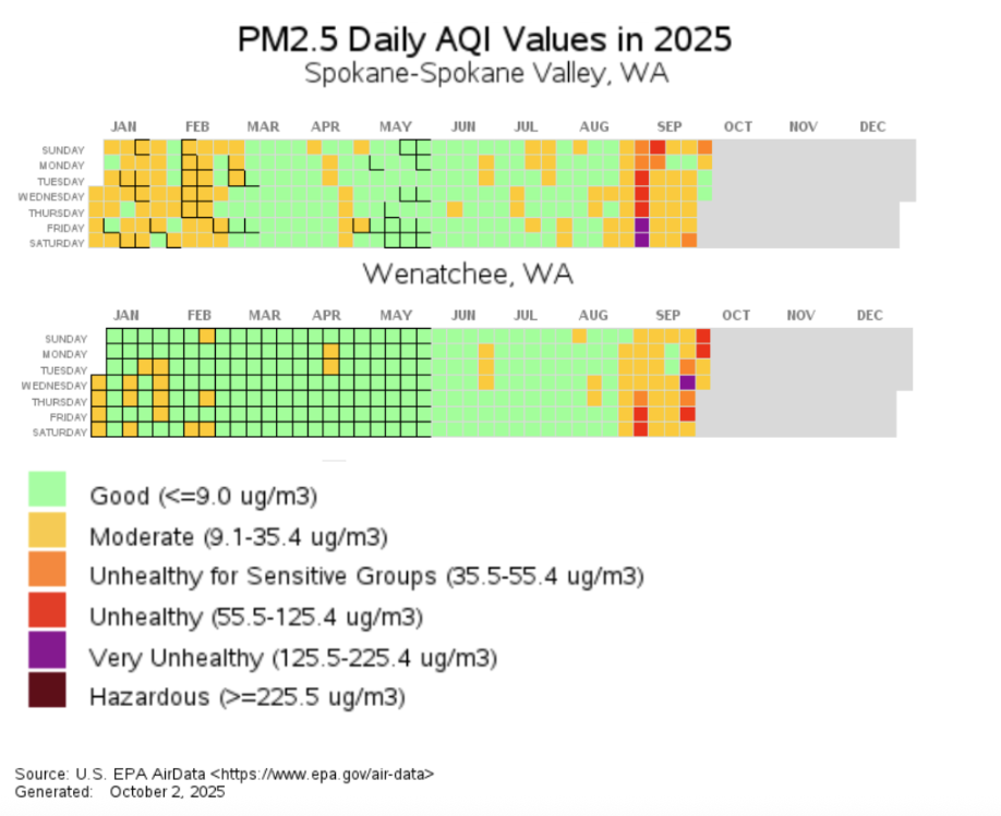 Daily Air Quality Index in Spokane and Wenatchee in 2025.
A few rain events brought some beneficial rainfall to the Olympics and western Cascades in the middle and latter half of the month, but the east slope fires have yet to receive enough rainfall to put an end to the wildfire season. The outlook for late October looks wet, so there is hope that these fires will be extinguished or greatly limited in the coming weeks as fall rains set in. Read more about the outlook for the next few months in the Early October Climate Outlook.
A reminder: Wildfire smoke is a serious concern for human health. Continue to stay up to date on local outdoor air quality levels and learn more about how to protect yourself during smoke season.