On November 14-15, 2021, 4.67” of rain fell at Bellingham International Airport, setting a new record for that location. This storm brought with it the most devastating flood that Whatcom County has seen in decades. There is so much that goes into preparing and recovering from an event like this. One small part is simply having good information on precipitation – we need observations like these both so that we can understand what happened, and as ground truth for our weather and climate models.
One of the surprising things about precipitation is that we don’t actually have adequate observations in most places. Precipitation can vary greatly across even a single neighborhood. With more comprehensive monitoring, we could more accurately track rainfall patterns and help communities better understand impacts of severe weather.
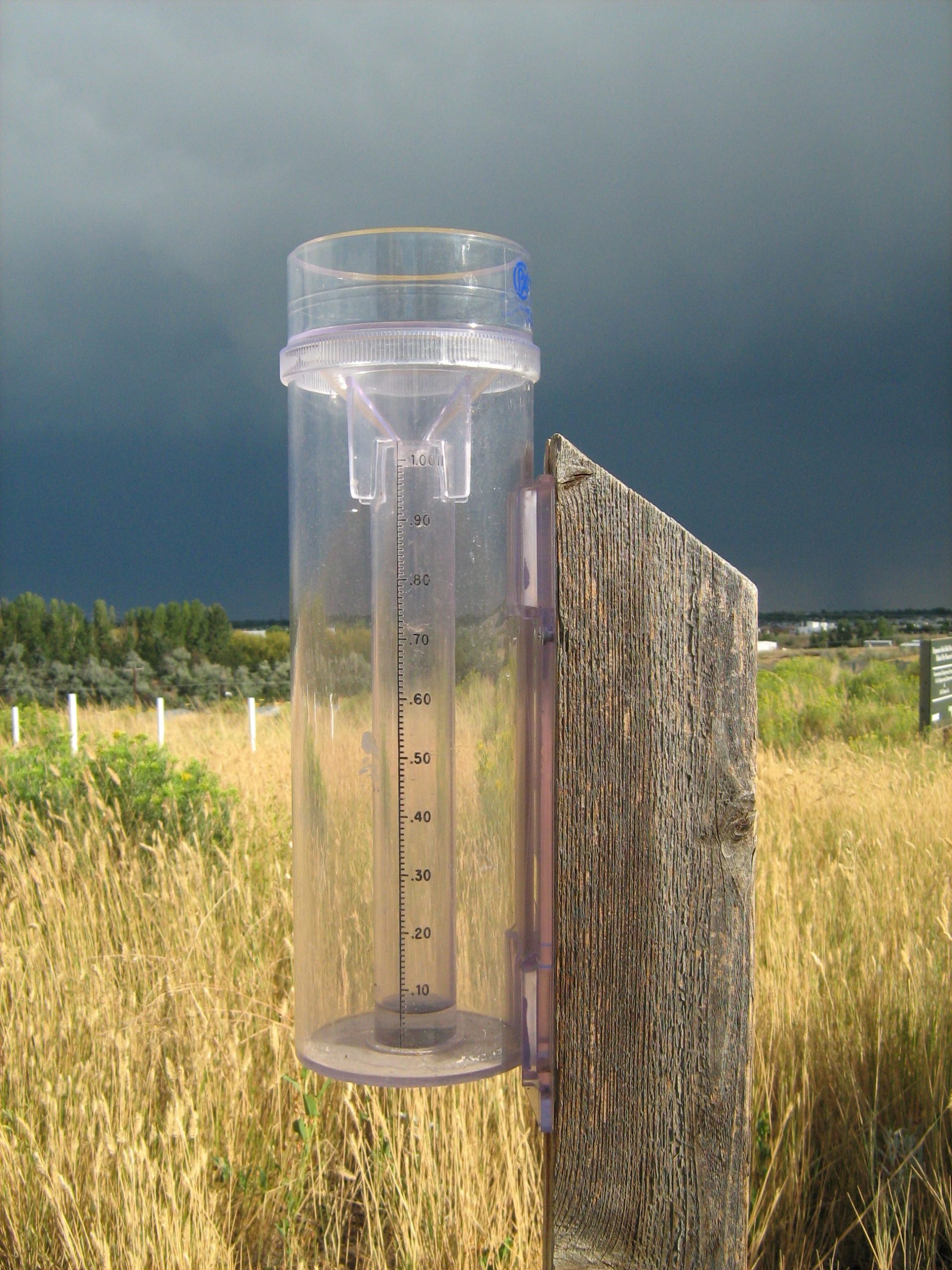
The Community Collaborative Rain Hail and Snow Network (CoCoRaHS, pronounced: /co-co-rah-s/) is a network of volunteer community members who report backyard precipitation measurements to help us understand local precipitation patterns on the scale of a neighborhood or even just a few city blocks. The network is made up of tens of thousands of these community observers all across the United States, Canada, and U.S. territories. Participating observers install a simple and inexpensive cylindrical rain gauge on their property, and commit to taking regular, daily measurements of precipitation at their location.
So what exactly are these rainfall measurements used for? These measurements aren’t just an interesting way to produce pretty maps of precipitation. They also have clear scientific and societal benefits. CoCoRaHS observations help weather forecasters and hydrologists understand how much rain has (or hasn’t) fallen in the recent past and provide ground-truth for precipitation and drought forecasts, which helps local communities prepare in advance.
How can we use CoCoRaHS observations to better understand extreme weather events? Let’s take a look at two recent events in Washington that highlight how the CoCoRaHS network can help us visualize both flooding and drought, two types of weather that are most impactful to humans and ecosystems.
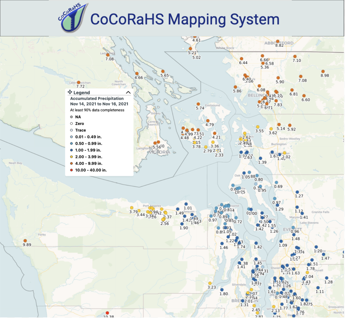
Total accumulation from November 14-November 16, 2021 in northwestern Washington.
Beginning on the wet side of things, the Nooksack River floods of November 2021 were one of our most devastating recent floods. From November 10 through the end of the month, a series of strong atmospheric rivers brought repeated rounds of heavy precipitation and flooding across the region and particularly along the Nooksack River. This heavy and persistent rain led to the evacuation of hundreds of residents in Whatcom and Skagit counties and communities across the border in British Columbia.
Particularly heavy rain on November 14 brought the 5th wettest day on record in Bellingham since 1949 and triggered numerous landslides across the region, closing many major roads and prompting water rescues. Floodwaters forced the closure of all roads in and out of the Lummi Reservation for days, leaving an entire community isolated.
Rainfall totals, mapped using the CoCoRaHS mapping system, show the stark contrast between very heavy rainfall in Whatcom, San Juan, and northern Skagit counties, while areas to the south got much less rain. Such a clear picture of this contrast in rainfall totals would be much more difficult without a network of dedicated community rainfall observers. When all was said and done, observers reported over 13.00” of rainfall for the month in the lowlands of Whatcom County, illustrating the local-scale nature of this event.
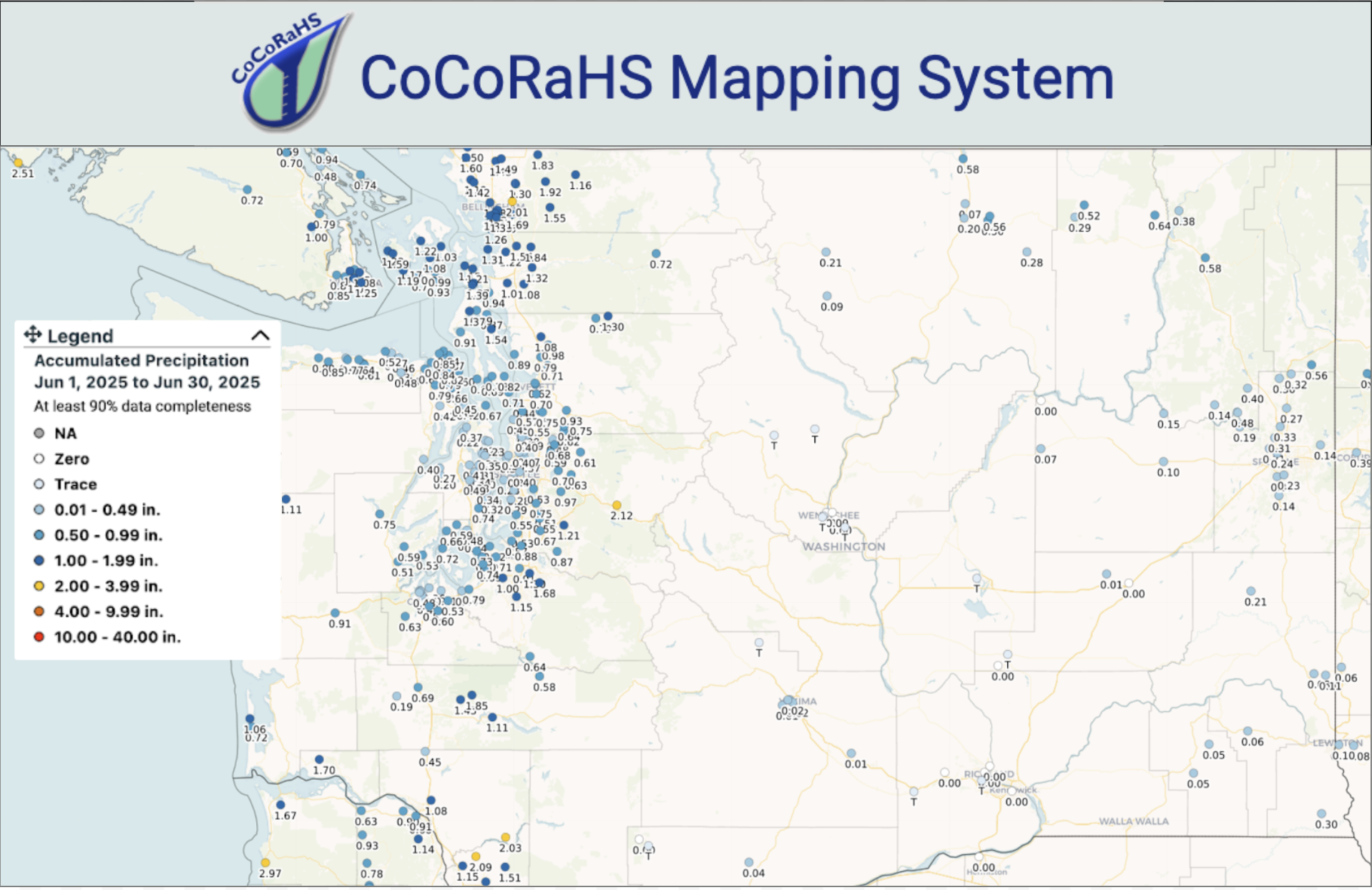
This example highlights how CoCoRaHS observations are crucial for heavy rain events. But they can also be helpful for tracking dry conditions. A recent example comes from our drought-stricken summer of 2025. Following the winter of 2024-2025, statewide snowpack was slightly below normal, and the 10th warmest June on record led to an earlier-than-normal meltout. In addition to low mountain snowpack and early season warmth, June 2025 was also the 3rd driest June since 1895. CoCoRaHS observations helped us understand the spatial extent of these dry conditions, as seen in the map of June 2025 precipitation below. Areas in western Washington received some beneficial precipitation during the month, but the totals were generally less than 50% of normal precipitation for the month.
Precipitation accumulation during June 2025 as recorded by CoCoRaHS observers.
The precipitation situation (try saying that five times fast!) in eastern Washington was even more extreme in June. Many areas received just trace precipitation over the entire month. Although June and July are typically dry in the Columbia Basin, many locations that normally receive around 0.75”-1.50” of precipitation in June recorded less than 0.25” with record lows in some spots. CoCoRaHS observations along the eastern slopes of the central and northern Cascades are especially important as there is a notable gap in radar coverage in this region, creating a blind spot in rainfall estimates. Trace rainfall CoCoRaHS reports near Wenatchee, smack dab in the middle of this coverage gap, helped to confirm that this region did in fact receive very little precipitation in June. This, coupled with dwindling mountain snowpack, heightened drought concerns for the upcoming summer. This information helps with earlier drought detection and confirmation of satellite and model estimates of drought conditions across the state. With more accurate information about drought and rainfall, communities can better understand the situations impacting them and access resources that may otherwise be unavailable.
Some of our community observers have been observing for many years, or even decades. These long and reliable records can aid our understanding of long-term precipitation patterns, helping improve and validate models, especially in areas where long-term weather stations are not available. Observers can also include notes about what they’re seeing – combined with the precipitation measurements, these reports often provide valuable context about local conditions. This leads to better forecasts and outlooks that climatologists can provide for people in agriculture, industry, outdoor recreation, and other sectors.
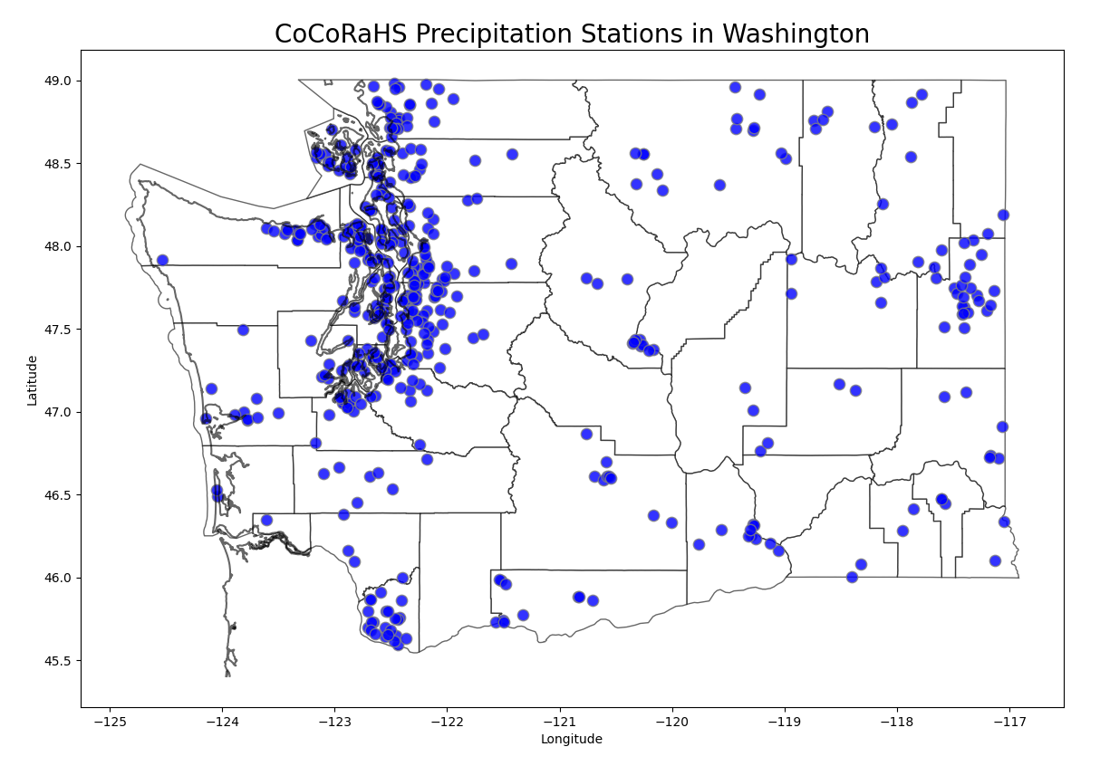
Map of active CoCoRaHS Observers as of 2025. The Washington State Climate Office serves as the statewide coordinator of the Washington CoCoRaHS Program.
Currently there are almost 650 dedicated observers across Washington state who report near-daily observations online or through the CoCoRaHS mobile app. A map of CoCoRaHS stations in Washington reveals clusters of observers around our main population centers of Seattle and the Puget Sound region, Vancouver, and Spokane with observers more widely scattered across rural areas of the eastern Cascades, Columbia Basin, and the Coast and Olympic Peninsula. On-the-ground observations are critical in remote or mountainous areas where few automated rain gauges exist, and where other ways to estimate rainfall, such as with radar data, may be less accurate. We hope to expand the CoCoRaHS program here in Washington, and are interested in recruiting new observers from every corner of the state. We would especially appreciate more observers in areas where stations are currently sparse, like the ones listed above.
Many observers enjoy tracking the weather they observe, seeing their data on the map, and comparing with others in their region. Others enjoy providing important data in areas where they are the only observer for their region. There are several forums for CoCoRaHS members to discuss weather and climate patterns, see how their data is used, and build community with others such as regular newsletters and online community groups.
Dedicated volunteers are crucial to making the CoCoRaHS network possible. If you are interested in becoming an observer, visit the CoCoRaHS website to learn more, purchase a rain gauge, access training materials, and register with the program to start reporting your observations. We are here to help. Please direct any questions about the Washington CoCoRaHS program to wash.cocorahs@gmail.com.
If you are already an observer, we encourage you to recruit your friends, family, and neighbors – rain gauges make wonderful gifts! Even local schools can access educational materials to implement an observation program. And remember, reporting zero rainfall is just as important as reporting heavy rainfall!