By Jacob Genuise
Key Messages:
- Snowpack is currently below normal in all major basins across the state
- Storms were warm, bringing mostly rain instead of snow. Drier than normal conditions occurred across the Olympics and portions of the southwestern Cascades which limited snowpack growth.
- Snowpack is furthest behind seasonal averages in the Olympics, western slopes of the Cascades, and far eastern Washington basins.
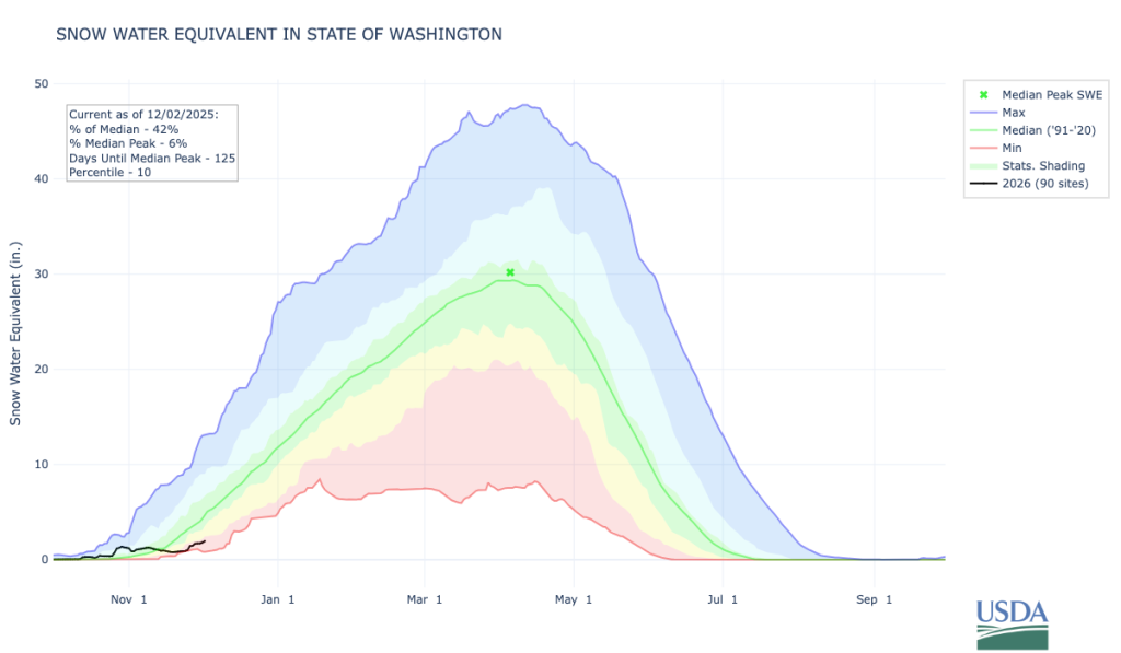 Statewide Snow Water Equivalent from October 1 through December 2, 2025. The solid green line represents the median SWE value from 1991-2020, and the black line represents SWE for the current water year.
Snowpack, as measured by snow water equivalent (SWE), has fallen behind average for this point in the season as indicated by the nearly flat Water Year 2026 statewide SWE plot. Despite numerous weather disturbances throughout the month, they tended to be on the warmer side. Warmer storms lead to more precipitation falling as rain instead of snow, especially at middle and lower elevations. As a result, statewide SWE was near record lows around the 24th and 25th. Snowpack has recovered slightly heading into December, but still remains lower than 90% of years on record (indicated by light red shading on the graph).
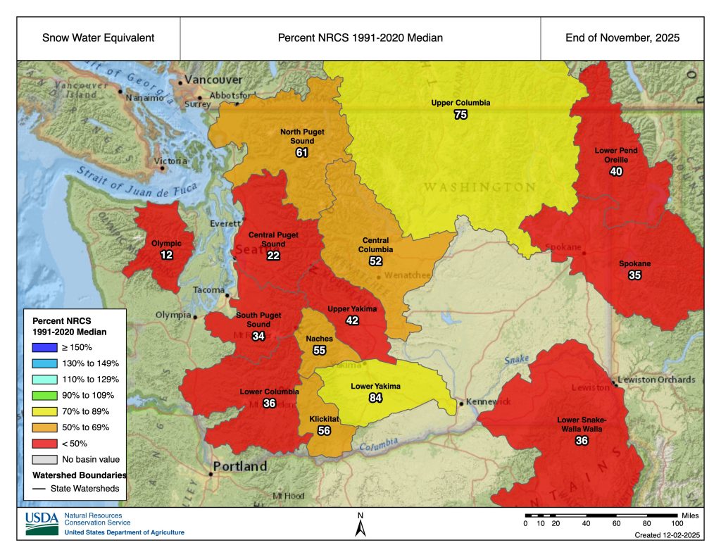 Snowpack, in terms of snow water equivalent, as of the end of November 2025.
The basin-level map of percent of median SWE shows below median snowpack in every major basin in the state. Basins shaded in red have less than 50% of median SWE as of November 30. These areas include the Olympics (only 12% of median SWE) and the western slopes of the Cascades (22-36% of median). Low snowpack in the Olympics and central and southwestern Cascades was also caused by drier than normal conditions.Only around 60-80% of normal precipitation fell in these regions in November during warmer, rain-dominant storms. In eastern Washington, snowpack observations in the Lower Snake-Walla Walla, Spokane, and Lower Pend-Oreille basins are also running low with only around 35-40% of median SWE as of the end of the month. The higher mountains of the northern Cascades fared a bit better, sitting around 61% of median, and the Naches, Klickitat, and Lower Yakima Basins are between 55-85% of normal.
The map of SWE change from the end of October to the end of November below reveals numerous stations had record low SWE increases throughout the month. These records are indicated by red dots on the station map below. Orange dots represent stations that recorded their second lowest November SWE increase on record.
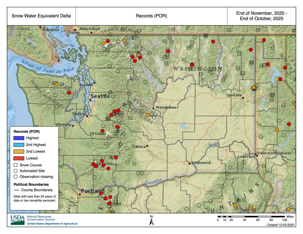 Change in SWE from the end of October through the end of November with records highlighted. Record low SWE changes are shown as red dots. 2nd lowest SWE changes are shown as orange dots.
According to the U.S. Drought Monitor, drought remains across much of the state, but has steadily improved over the past month. Areas along the Pacific coast, western Olympics, Klickitat county, and the central and eastern Columbia Plateau are no longer experiencing drought conditions (D0 ‘Abnormally Dry’ or None on the U.S. Drought Monitor scale). Drought conditions remain across all other areas of the state, and Extreme Drought (D3) remains across far southeastern Washington near Walla Walla, Pomeroy, and Pullman. No areas of Exceptional Drought (D4) currently exist in the state.
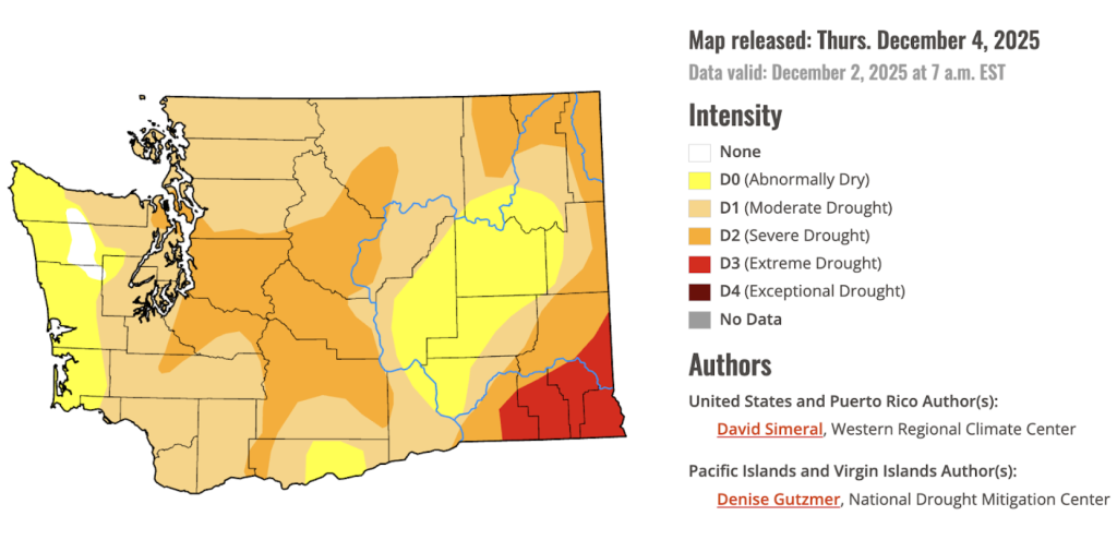 U.S. Drought Monitor for Washington. Data valid on December 2, 2025.