By Jacob Genuise
Key Messages:
- A warm atmospheric river event from December 8-11 brought widespread flooding to both western Washington and the eastern slopes of the Cascades. Read more in this article and in this Month’s Climate Matters.
- Very warm temperatures during the first half of the month set numerous daily and monthly temperature records.
- Another storm from December 15-18 brought mountain snow and strong winds in excess of 50-80+ mph for much of the state.
 December 2025 daily high (red bars) and low (blue bars) temperatures as well as normal high and low (pink and light blue lines, respectively) for SeaTac Airport. Gray shading denotes weekends. Normals are based on the period 1991-2020.
 December 2025 daily high (red bars) and low (blue bars) temperatures as well as normal high and low (pink and light blue lines, respectively) for Spokane. Gray shading denotes weekends. Normals are based on the period 1991-2020.
The first half of December was marked by much warmer than normal temperatures and plenty of wet weather. The stretch from December 5-19 brought daily high temperatures of 10-15°F above normal in western Washington and 15-20°F above normal in eastern Washington. Daily observed low temperatures often approached or exceeded normal daily high temperatures during this period.
This warm spell broke 382 daily high minimum temperature records across the state (that is, the warmest low temperature on record for a particular calendar day). 17 stations also broke their monthly high minimum temperature records (that is, the warmest low temperature on record for the full month of December; these records are much harder to break). Source: NCEI daily weather records tool.
On December 10, the Yakima airport reached 72°F, approaching the statewide all-time warmest December temperature record of 74°F from the town of Omak on December 1, 2021.
This warm stretch also coincided with multiple warm atmospheric river events and widespread flooding across western Washington. This flooding also impacted communities on the eastern slopes of the Cascades where heavy rain also fell.
Moderate mountain rains during the first week of the month saturated soils and set the stage for this flooding event. Then, the worst of this flooding occurred from December 8-11 as a strong atmospheric river meandered across the state. Previously saturated soils coupled with very high snow levels due to warm conditions meant much of this mountain precipitation fell as rainfall rather than snow. The Lynn Lake and Skookum Creek SNOTEL sites in the western Cascades recorded the highest precipitation amounts of any stations in the state during this event with 21.80” and 19.70”, respectively. These sites are located notably west of the crest of the Cascades in King County.
This rainfall led to rapid runoff into streams and rivers and subsequent flooding. Read this Month’s Climate Matters piece to learn more about how this flooding event compares to past events.
Rivers swelled to near or above record stage at nearly every major river in western Washington. A new streamflow record occurred on the Skagit, Nooksack, and Snohomish rivers prompting levee failure concerns and numerous evacuations. The USGS reported that 10 rivers set new all-time record-high crests. The prolonged nature of this event combined with the need for dam releases to make room for additional rainfall in the following days put stress on levees and prompted a variety of warnings and responses.
On the east side of the Cascades, major flooding occurred in the Yakima, Wenatchee, Methow, and Stehekin rivers. The town of Mazama, along SR-20 west of Winthrop and Twisp, broke their 3-day rainfall record with 5.11” of precipitation (previous 3-day record: 4.97” in 1990). Mazama also shattered their monthly rainfall record with 11.61” of precipitation (previous record: 8.58” in December 1996). Numerous washouts on US-2 between Skykomish and Leavenworth cut off access through Stevens Pass for weeks. The small town of Stehekin also grappled with historic flood damages with runoff worsened by the 2024 Pioneer Fire burn scar. Storm event total rainfall is shown on this map of CoCoRaHS observations across the state. Precipitation amounts of 3-6” were common in the western Washington lowlands with 10-20” recorded in the windward western slopes of the Cascades and Olympics. A notable Olympic rain shadow limited precipitation amounts in the central sound with some stations near Port Townsend recording less than 1” of rainfall during the event.
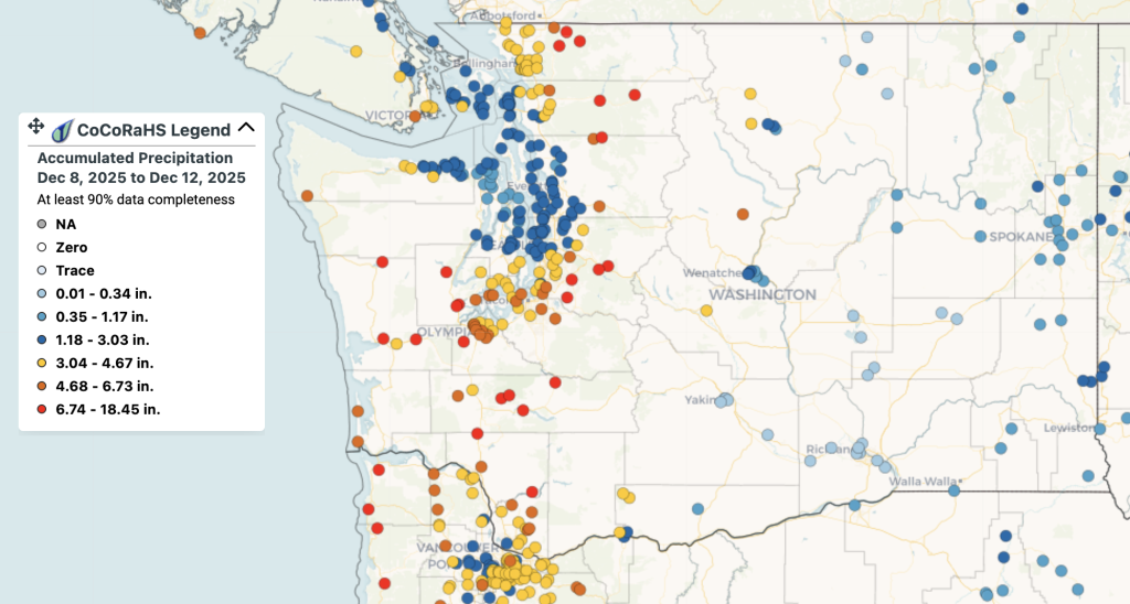 Map of rainfall during the Dec 8-11 flooding event as reported by CoCoRaHS Observers.
Additional precipitation moved in from December 15-18, renewing flooding concerns due to initially high snow levels (i.e. snow occurring only in high elevations). Thankfully snow levels dropped during this event, limiting flood risk by storing this water as much-needed mountain snowfall. The main story with this second event ended up being very strong winds across the state. Gusts from this event were impressive with gusts of 51 mph at SeaTac, 58mph in Hoquiam, and 71mph at Whidbey Naval Station. These winds led to a power outage for nearly all of Whidbey Island and hundreds of thousands of customers statewide.
Winds at numerous Cascade passes were even higher with gusts to 99 mph near White Pass and 112 mph just above Snoqualmie Pass at the Alpental station. Across eastern Washington gusts routinely exceeded 60 mph including 81 mph at the Pullman Moscow Regional Airport, 75 mph at Spokane International Airport, and 63 mph at Wenatchee Pangborn. This windstorm then moved east and led to one of the most widespread windstorms in recent memory. High wind warnings stretched across much of the western United States, the central and northern Plains, and eventually into the northeastern U.S. in the days that followed.
Wet and active weather then gave way to drier and cooler conditions by the 28th, bringing persistent fog but a break from flooding concerns as we headed into the new year.