By Jacob Genuise
Key Messages:
- Active weather brought a brief period of much-needed heavy mountain snowfall at the start of the month.
- A strong and persistent ridge of high pressure then brought an extended streak of dry weather.
- This ridge also brought persistent freezing fog across eastern Washington and nightly frosts and patchy freezing fog to western Washington.
 January 2025 daily high (red bars) and low (blue bars) temperatures as well as normal high and low (pink and light blue lines, respectively) for SeaTac Airport. Gray shading denotes weekends. Normals are based on the period 1991-2020.
 January 2025 daily high (red bars) and low (blue bars) temperatures as well as normal high and low (pink and light blue lines, respectively) for Spokane. Gray shading denotes weekends. Normals are based on the period 1991-2020.
January began with a brief warm spell followed by a period of active weather from January 3-10 as lowland rain and heavy mountain snow impacted the state. January 5-8 brought the heaviest period of mountain snow with a total of 35” at Mt. Rainier Paradise, 34” at Mt. Baker, 27” at Snoqualmie Pass, and 25” at Stevens Pass as reported by the National Weather Service.
Some areas of the eastern foothills of the Cascades, ridgelines of eastern Washington, and the Spokane Metro picked up some decent snowfall on January 7 including 11.0” at Cle Elum, which sits only 500 feet higher in elevation than nearby Ellensburg, and 7.0” at Spokane International Airport. Daily snowfall totals for January 7 are listed in the table below. You may even notice a few CoCoRaHS observers on this list. Learn more about how you can submit snowfall and rainfall observations as a CoCoRaHS volunteer.
While most lowland areas across western Washington received rain during this event, some light lowland snow fell 3 miles south-southeast of Bellingham where I-5 curves through the Chuckanut formation. Because it is higher and therefore colder, and subject to uplift due to the higher terrain, this area often sees snowfall when temperatures are too warm to support snow in most of the surrounding lowlands.
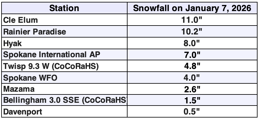 Selected daily snowfall totals on January 7, 2026 as reported by various observing networks including CoCoRaHS Observers.
A strong ridge of high pressure then began to build across the region and brought with it unseasonably warm temperatures by January 12 and 13. On the 13th, many stations tied or set daily high temperature records including 69°F at the Canyon Creek (prev. 61°F in 2009) and Dry Creek (prev. 58°F in 2018) RAWS stations in Skamania County, 60°F at Tacoma McChord AFB (prev. 55°F in 1966), 58°F at Seattle WFO (tied with 2019), and 53°F at Spokane Intl. AP (tied with 1955). The Sasse Ridge SNOTEL near Cle Elum Lake broke the all-time monthly January high temperature record with 60°F beating the previous January record of 59°F set in 2015. Records for this station go back to 1984.
The ridge that brought these warm temperatures also brought dry weather by January 14 with many areas across the state recording 2+ consecutive weeks with no precipitation. That’s not a typical Washington January by any stretch of the imagination. Read our January 2026 Climate Summary to learn more about this dry spell and our Snowpack and Drought Summary to learn about its impact on snowpack.
This ridge of high pressure also led to the development of persistent fog across the Columbia Basin and patchy fog in southern Puget Sound, as seen on this January 10 satellite imagery as an example.
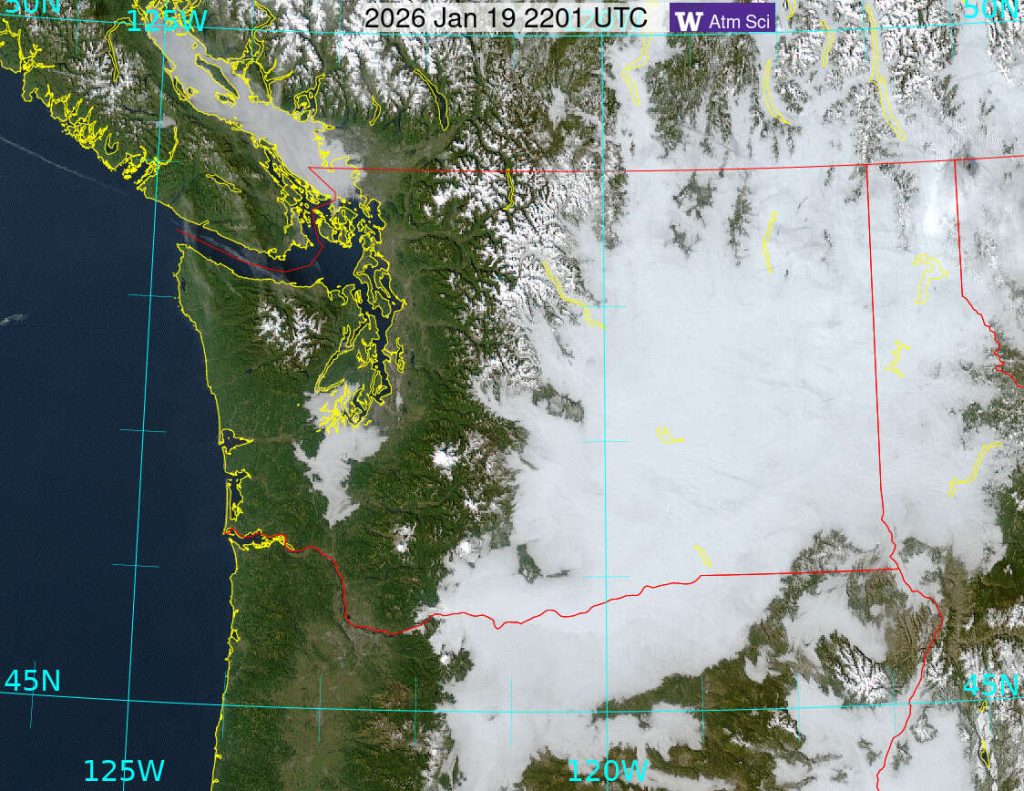 Visible Satellite imagery of persistent low clouds and fog at 2:01pm local time on January 19, 2026.
You can also see evidence of this persistent fog in the daily high and low temperature graphs of Seattle and Spokane at the beginning of this article. Beginning with the bottom graph for Spokane, from January 16-22 the spread between the daily high and low temperatures was only a couple of degrees each day as dense fog trapped warmth near the surface and kept overnight temperature from dropping much below daytime highs.
In contrast, Seattle’s daily temperatures over the same period show much larger swings between high and low temperatures. This is due to the fact that fog was absent in the evenings, allowing for rapid cooling into the overnight hours under clear skies before patchy fog could form late overnight. Nightly temperatures frequently fell into the mid-20s across western Washington, and led to multiple broken or tied daily minimum temperature records in areas of the state not socked in with fog. However, the warm spell on January 12 and 13 was much more anomalous with roughly 3 times the number of broken and tied daily temperature records due to abnormal warmth.
Wet and active weather then finally returned on January 28 as lowland rain and some mountain snow moved in to close out the month.