By Jacob Genuise
Key Messages:
- Averaged statewide, December 2025 was the warmest December on record. January -December 2025 is tied with 1934 as the second warmest year on record in Washington.
- Averaged statewide, December ranked as the 5th wettest December on record, with most portions of the state receiving much above normal precipitation.
- The exceptions were in the central Puget sound and central Columbia Plateau/Okanogan Highlands, where monthly precipitation was near or slightly below normal, largely due to unfavorable storm track and rain shadowing for these areas.
- Five months in 2025 ranked among the top-10 warmest on record for that specific month.
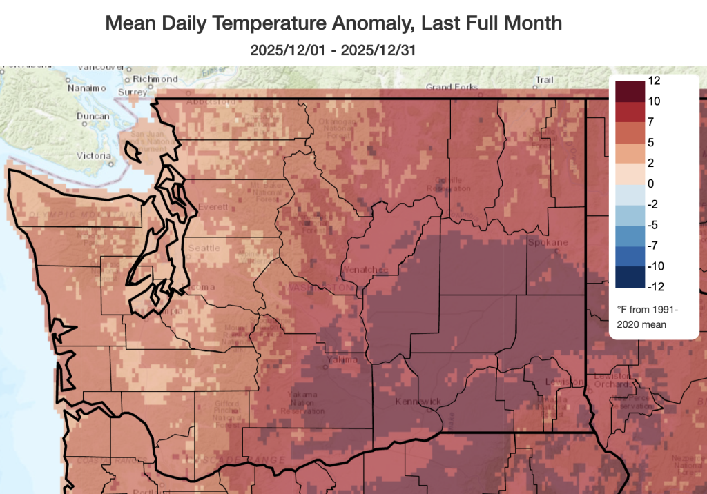 December 2025 mean temperatures compared to 1991-2020 normals.
December was the warmest December since at least 1895. A considerable warm period through much of the first half of the month boosted monthly average temperatures well above normal. In western Washington, monthly temperatures ran 3-5°F above normal including in Olympia (+4.5°F, fifth warmest on record), SeaTac (+3.2°F, third warmest on record), Hoquiam (+4.2°F, second warmest on record), and Vancouver (+6.2°F, a new monthly record).
Temperatures were even warmer relative to normal across eastern Washington including at Spokane (+8.4°F), Yakima (+8.4°F, a new monthly record), Pullman (+8.0°F, a new monthly record), Wenatchee (+8.5°F, a new monthly record), and Hanford (+9.6°F, a new monthly record). The table below summarizes selected monthly records and rankings across the state. A few stations exceeded the previous records set just two years ago in December of 2023. Statewide, temperatures were 6.4°F above the 1991-2020 average.
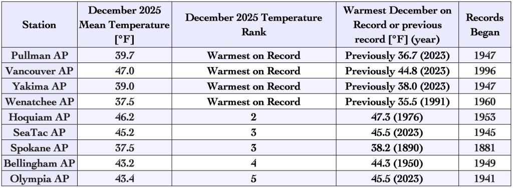 Monthly temperature rankings and records for December 2025.
On December 10, the Yakima Airport recorded a high temperature of 72°F, just two degrees shy of the statewide highest December temperature ever recorded (74°F at Omak on December 1, 2021)
Looking back at the calendar year as a whole, 2025 was an impressive year for Washington, with multiple warm temperature records. There were five months in 2025 that ranked in the top-10 warmest respective months on record including July (10th warmest), August (4th warmest), September (warmest on record), November (7th warmest), and December (warmest on record). The March-December 2025 period was also the warmest on record, and 2025 as a whole was the second warmest on record.
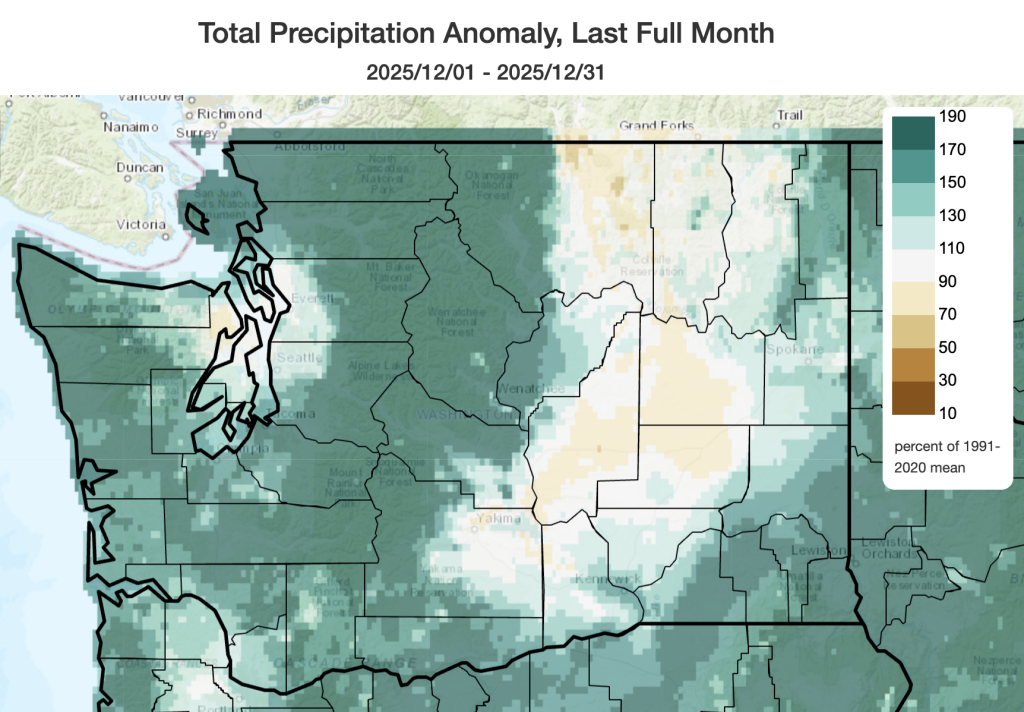 December 2025 precipitation as a percent of 1991-2020 normals.
As for precipitation, December 2025 was the 5th wettest December on record with most areas of the state experiencing well above normal precipitation. Due to two very wet events on December 8-11 and December 15-18, portions of the Cascades recorded over 250% percent of normal precipitation. The Olympic mountains and Pacific coast as well as far the southeastern and northeastern corners of the state recorded nearly 200% of normal precipitation. Hoquiam (137%), Bellingham (186%), Wenatchee (147%), the Tri-Cities (171%) and Pullman (260%) all recorded above normal precipitation. Mazama also shattered their previous monthly record with a total of 11.61” of rainfall in December 2025. The previous monthly record was 8.58” in December of 1996. Despite this ample precipitation across the state, warm temperatures limited snowfall in most areas of the state including just 3.6” in Spokane for the month. The normal snowfall for Spokane in December is 13.6”.
Notable exceptions to these wetter than normal conditions included the central Columbia Plateau and the central Okanogan Highlands where rain shadowing led to areas of near or just below normal precipitation. Precipitation was near 78% of normal in Omak and 70% of normal in Ephrata. The Olympics also cast a rain shadow on the central Puget Sound causing precipitation to be near seasonal normals from Seattle on north through Snohomish County despite very wet conditions elsewhere in western Washington.
 Total precipitation accumulation in December 2025, in inches.
December total precipitation is shown on the map above with portions of the Cascades and western slopes of the Olympics recording upwards of 30” for the month and 10-15” of rainfall across the western Washington lowlands outside of the Olympic rain shadow.
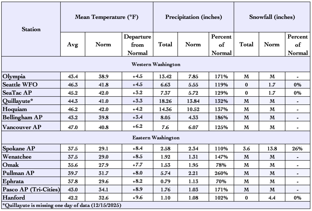 December 2025 climate summaries for select locations around Washington. Anomalies are relative to a climate normal baseline of 1991-2020.