By Jacob Genuise
Key Messages:
- A warm spell kicked off the month, breaking numerous daily high temperature records.
- Colder air arrived in the middle of the month dropping minimum temperatures into the 20s in western Washington and into the teens and single digits across much of eastern Washington.
- Wetter weather later in the month supported some modest increases in mountain snowpack.
 February 2026 daily high (red bars) and low (blue bars) temperatures as well as normal high and low (pink and light blue lines, respectively) for SeaTac Airport. Gray shading denotes weekends. Normals are based on the period 1991-2020.
 February 2026 daily high (red bars) and low (blue bars) temperatures as well as normal high and low (pink and light blue lines, respectively) for SeaTac Airport (top) and Spokane (bottom). Gray shading denotes weekends. Normals are based on the period 1991-2020.
February began with warmer than normal conditions across much of the state. A couple of storms early in the month brought precipitation to western Washington, but warm temperatures hindered snowpack benefits from these storms. Temperatures were particularly warm on February 4 and included a high temperature of 62°F at SeaTac. Although this was not a record at SeaTac, numerous daily high temperature records fell across Washington including 64°F in Olympia (prev. 60°F in 2009), 61°F at Rainier Paradise (prev. 58°F in 1935), and 58°F in Pullman (prev. 56°F in 1963). Temperatures were particularly warm for the western slopes and valleys of the Cascades thanks to warm, dry, descending easterly winds.
Colder air then arrived near the middle of the month along with some moisture that brought trace snow to some of the Puget Sound lowlands, including trace amounts at SeaTac Airport. Some valleys outside of the urban corridor saw minor snow accumulations in the early morning hours of February 18 including a couple of inches of heavy wet snow in Lake Stevens and Granite Falls. Impacts were limited to broken branches and school delays.
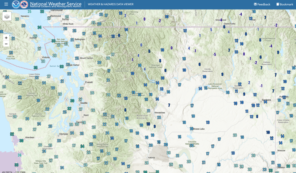 Low temperatures on the morning of February 20, 2026.
The coldest temperatures arrived on the morning of February 20. Many in western Washington woke up to temperatures in the 20s while locations in the upper Columbia Plateau of eastern Washington started the morning in the teens and single digits. Sub-zero temperatures developed in the far northern tier of eastern Washington, as seen on the map of low temperatures below. Although this cold snap was notable, it did not break many daily low temperature records. Port Angeles Fairchild Airport was the only station with a reasonably long period of record that managed to break a daily low temperature record with a low temperature of 22°F on February 20 (previously 25°F in 2020; records began in 1998).
Following this cold spell, temperatures moderated to near seasonal normals across western Washington and slightly above normal across eastern Washington. Numerous rounds of precipitation then brought mountain snow and valley rain to close out the month. While this active pattern led to some modest increases in our mountain snowpack – see the map below of the 24-hour change in SWE on February 24 – snowpack remains well below normal in all major river basins. See our February 2026 Snowpack and Drought Summary for more information on snowpack conditions.
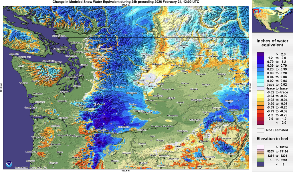 24-hour change in snow water equivalent on February 24, 2026.