By Jacob Genuise
Key Messages:
- Statewide temperatures were above normal, marking the 9th consecutive month with above normal statewide temperatures.
- Temperatures were +2-4°F above normal across the eastern slopes of the Cascades and across much of eastern Washington.
- Areas along the western Olympic Peninsula and in far SW Washington experienced slightly below normal temperatures.
- Precipitation was well below normal for much of the state. Most areas from Puget sound eastward received less than 30% of normal July precipitation.
- On the western Olympic Peninsula from Quinault north through Neah Bay, a wet period later in the month resulted in well above normal monthly precipitation including 265% of normal precipitation at Quillayute.
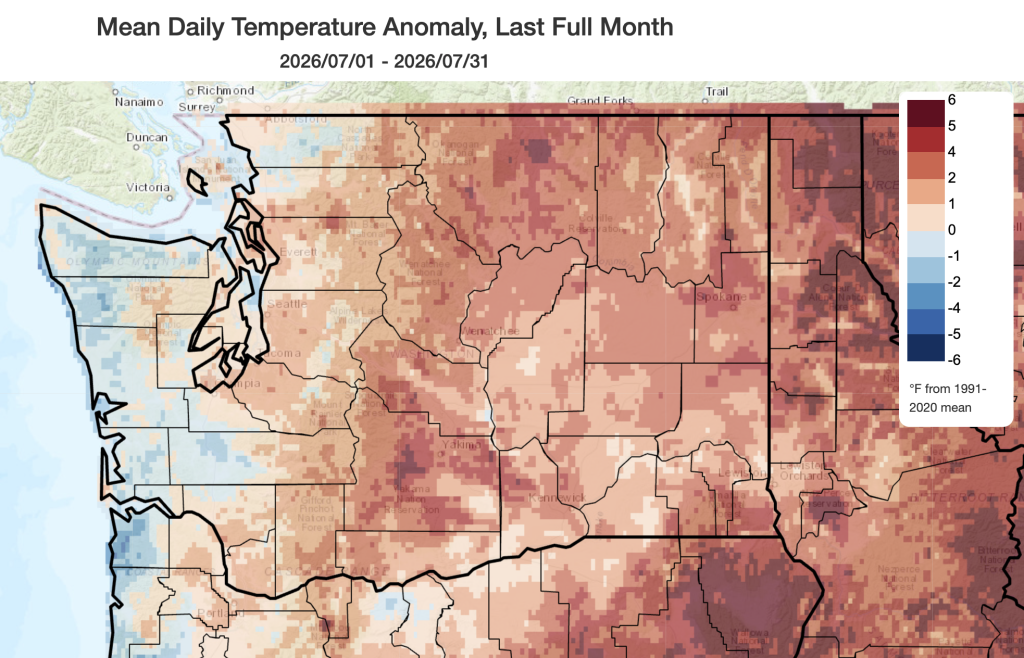 July 2026 mean temperatures compared to 1991-2020 normals.
Temperature: Temperatures were above normal for most areas across the state, especially from the Cascades eastward. Temperatures were warmest relative to normal on the eastern slopes of the Cascades, the Okanogan highlands, and in far eastern Washington. Temperatures were +3.0°F above normal in Omak, +2.7°F above normal in Spokane, +1.5°F above normal in Pasco, and +0.7°F above normal in Wenatchee last month. Across the western slopes of the Cascades and Puget Sound, temperatures ran near or slightly above normal including -0.2°F at SeaTac, -0.1°F in Olympia, and +1.1°F at the Seattle WFO in Sand Point.
Periods of onshore flow brought cooler air off the Pacific into communities on the outer coast, resulting in near normal or slightly below normal temperatures in the towns of Hoquiam (+0.3°F) and Quillayute (-0.7°F). Other areas on the outer coast were as cool as 1-2°F below normal. This cooler onshore flow contributed to enhanced west-to-east pressure gradients across the Cascade Mountains, and gusty downsloping winds on their eastern slopes and into eastern Washington, which helped to fan multiple wildfires across the state. Read more about wildfire in this month’s Climate Matters. Current wildfire information is available from the Washington State Department of Natural Resources. Poor air quality has also been reported across the entire state in late July and early August with particularly persistent poor air quality near Leavenworth, Wenatchee, Spokane and much of eastern Washington. We acknowledge the terrible destruction of recent fires in Eastern Washington and Spokane, as well as on the Colville Reservation. Our hearts are with those impacted. Please consider supporting recovery efforts in these areas.
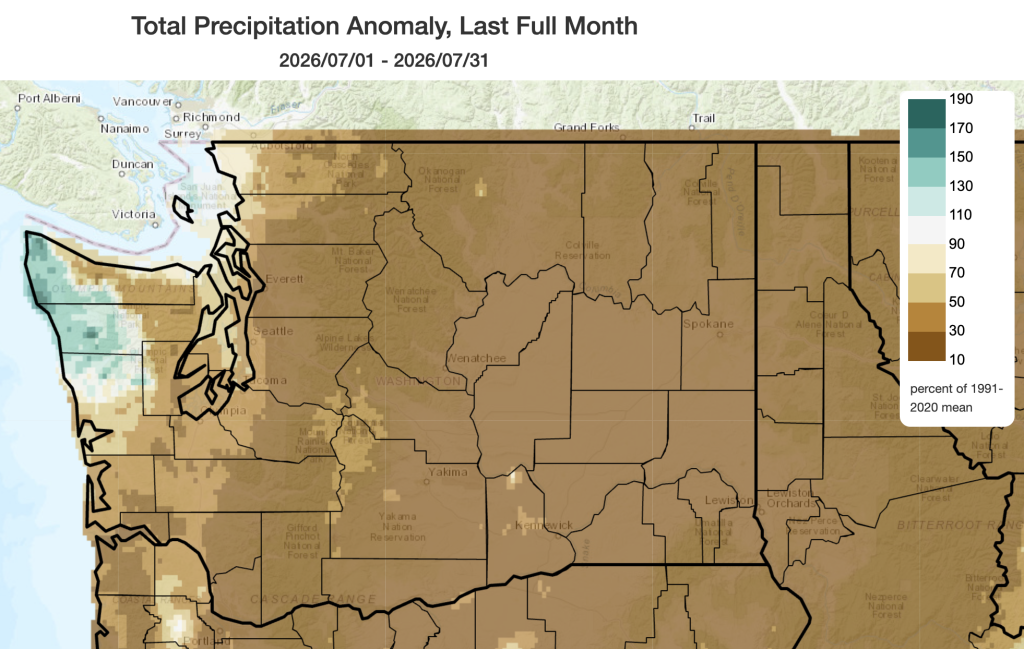 July 2026 precipitation as a percent of 1991-2020 normals.
Precipitation: July was significantly drier than normal across most of Washington. Although July is typically the state’s driest month, many locations received little to no rainfall. Most areas east of Puget Sound recorded less than 30% of normal precipitation, and there was only trace rainfall in both Spokane and in Pullman. Trace precipitation means that precipitation was observed falling in the air, but was not enough to be measured (typically <0.01”). While it is not entirely unusual to see near-zero precipitation in eastern Washington during the climatologically driest month of the year, many of these areas have been much drier than normal over the past 90 days as well. Eastern Washington, including areas near Spokane, Walla Walla, and Pullman, has experienced record low precipitation over this period.
Drier than normal conditions also occurred across portions of western Washington including the southern outer coast and across Puget Sound including only 61% of normal precipitation in Hoquiam, 23% of normal precipitation in Olympia, and 14% of normal precipitation in Vancouver. Bellingham was the exception to this rule across Puget Sound with near normal precipitation for the month (109% of normal).
A wet period from July 25-28 brought significant rainfall to a small portion of the northwestern Olympic Peninsula. This resulted in above normal monthly precipitation in this region. Quillayute recorded an impressive 1.56” on July 26. This was the 8th wettest July day on record at this station. However, this was a far cry from the record wettest July day in Quillayute when 5.35” of rainfall fell at the airport on July 11, 1983.
More information on the day-to-day variations in weather for the past month and the warm/cold and wet/dry streaks can be found on the revamped National Weather Service climatology pages; you can access locations within the Seattle, Spokane, Portland, and Pendleton forecast areas.
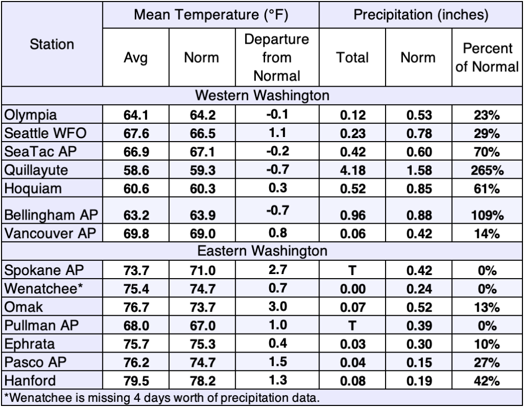 July 2026 climate summaries for select locations around Washington. Anomalies are relative to a climate normal baseline of 1991-2020.