By Nick Bond
Summer visitors to WA state are sometimes struck by how cool it is during the late night and early morning hours, and how late in the day it stays warm. This can be especially the case during our hottest weather, when peak temperatures often occur at 5 to 6 PM local time. By that time of the day the sun is lower in the sky, of course. Does WA state really experience a different diurnal cycle in temperature than other parts of the US, and if so, what might explain it?
For starters, here we will review the hourly air temperatures reported in Seattle (KSEA) and Spokane (KGEG) during two of the hotter days this past summer, 30 July and 16 August 2020. As shown in Figure 1, during both days at the two locations, the highest temperatures were late in the afternoon, specifically at 5 PM local time in Seattle and from 4 to 6 PM local time in Spokane. It bears noting that these times are daylight savings time, and so subtract an hour for standard time, which is roughly in phase with the sun. In other words, during daylight time, the sun is highest in the sky at around 1 PM. Even so, the temperature traces in Figure 1, which are highly representative of warm summer days in WA, show that temperatures climb for about 4 hours after the solar noon. Of course our warm summer days occur with negligible cloudiness, at least in the afternoon. Hang on to that thought.
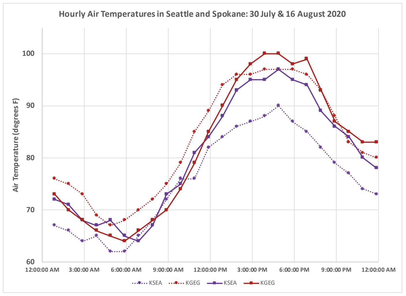 Figure 1: Hourly air temperatures (degrees F) for Seattle (KSEA; purple) and Spokane (KGEG; crimson) during 30 July (dotted lines) and 16 August (solid lines) of 2020. Times are in Pacific Daylight Time (PDT).
For a climatological perspective, we turn to data from the National Diurnal Climatology, available at http://www.microclimates.org/diurnal/index.html, with also a link on our website. Shown here are tables for Seattle (KSEA) and Spokane (KGEG) that list average values of a variety of meteorological parameters for each hour of the day during the month of August. Both Seattle and Spokane have 3 PM local standard time (4 PM local daylight time) as the warmest time of the day on average. The same kind of compilation for Portland, Maine (Table 1b) indicates 12 noon as the warmest time of day, on average. A similar diurnal cycle in temperature during August occurs in Boston, MA (Table 1a) where 12 noon and 1 PM local time are the hours with the warmest average temperatures. The latitudes of those two locations are a few degrees less than that of Seattle and Spokane, but at first blush the reason(s) for this discrepancy may not be obvious.
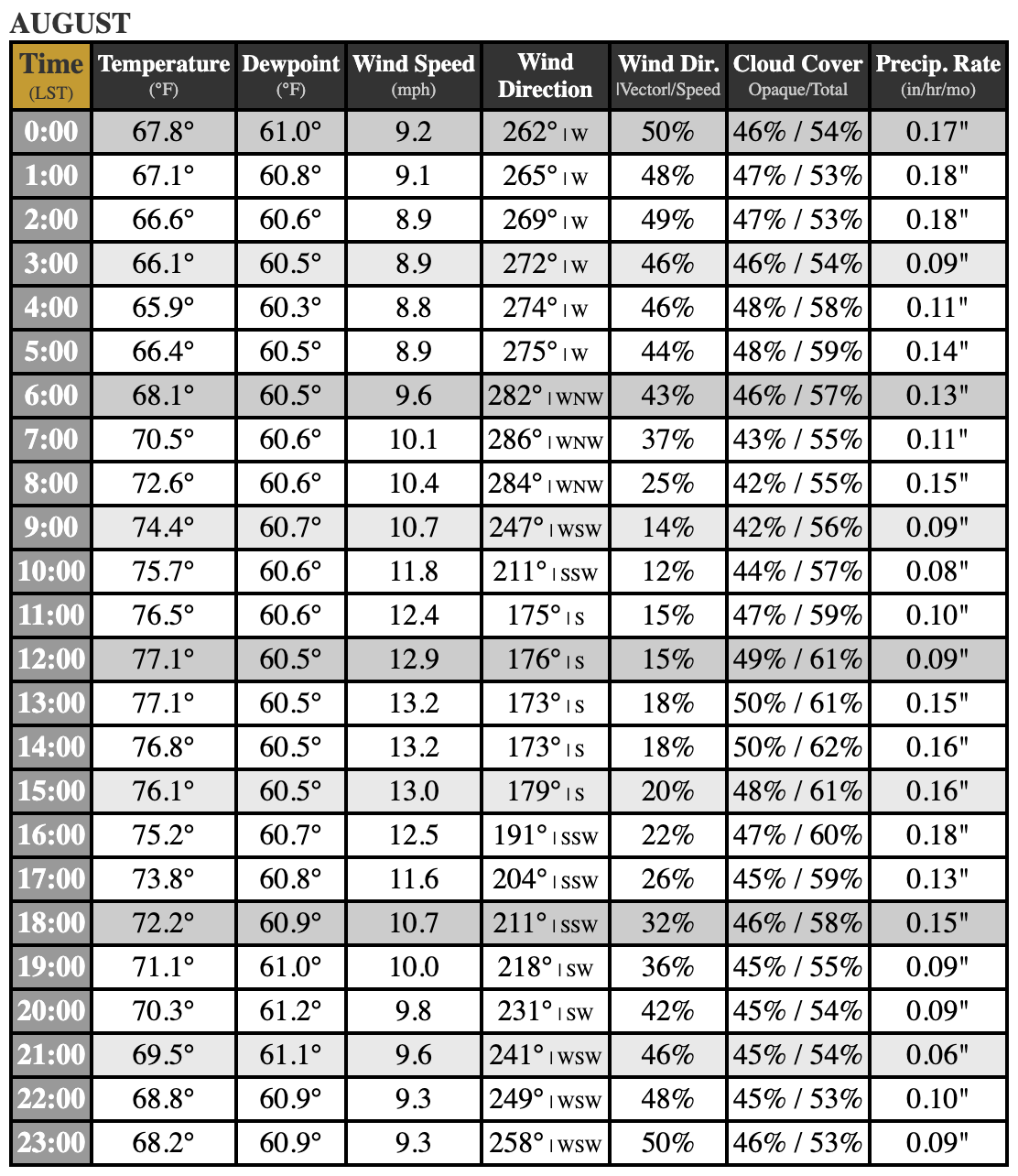 Table 1a: Boston
 Table 1b: Portland
 Table 1c: Seattle
 Table 1d: Spokane
Table 1.(a-d) Hourly averages of various weather parameters during the month of August. The column for Wind Dir. Vector/Speed essentially refers to the steadiness in the wind direction with lower (higher) percentages representing lesser (greater) consistency in the wind direction. The last column (Precip. Rate) refers to the average amount of rain during that hour of the day for the month of August as a whole.
Perhaps the differences in the diurnal temperature cycles are linked to their counterparts in cloudiness and precipitation, as shown in the tables included here. Seattle (Table 1c) tends to have greater cloudiness in the morning than in the afternoon in August, and for that matter, during all of summer months, but not winter months. Such a transition in cloudiness occurs to a lesser extent and later in the afternoon in Spokane (Table 1d), and for that matter, the amount of heating that occurs there during the early afternoon is less than that in Seattle. A different diurnal cycle in cloudiness is observed in Portland and Boston, and other locations in the eastern US, where there is a tendency for greater cloudiness in the afternoon. They also tend to have greater precipitation in the early and middle afternoon than during the morning. Many of their summer days include the building of cumulus clouds during the middle of the day that develop to the point where they produce rain, which cools things off. To be sure, that does not happen every day but it appears often enough to clip afternoon temperatures in the mean. Stratus and stratocumulus clouds are more common in our neck of the woods, and they more often dissipate, rather than grow, with the daytime heating.
Tables 1a-1d include average wind speeds and directions for each hour of the day, and the diurnal cycle in the winds may also impact the corresponding air temperatures. This is hypothesized to be particularly the case in Seattle, where there is a clockwise rotation in the winds from the west in the middle of the day off the nearby cool waters of Puget Sound; to a flow more out of the northwest later in the afternoon, and hence a longer fetch over the warmer land. It is not obvious how the diurnal cycles in the winds influence the progression of daytime temperatures at the other 3 locations considered here; the kind of analysis required to sort that out is far beyond the scope of the present piece.
Getting back to the subject of our clouds, perhaps you witnessed them sort of trick visitors from other parts of the country, at least back in the pre-pandemic days when we got so many of them. Many react to seeing clouds in the morning by thinking the afternoon is liable to be a washout, also given Seattle’s – if not eastern Washington’s – undeserved reputation for rain during summer. But most residents here know better, and try to get outdoors as much as possible during our mostly delightful summer afternoons. After all, it won’t be long before the weather of autumn is upon us and we are grateful for Gore-ex.