By Karin Bumbaco
The “El Niño watch” issued by the Climate Prediction Center is still in effect, with the expectation that a weak or moderate El Niño will develop this winter. Appropriately, media reports have focused on the increased odds of a warmer and drier winter due to El Niño, with the warmer than usual temperatures being more likely to occur. Sometimes it gets lost in the reporting, but there are plenty of nuances here. For example, even though seasonal mean precipitation is often below normal and April 1 snowpack is lower than normal in WA state during El Niño events, there is still a risk of significant flooding.
A potent reminder of this risk is the extreme event that occurred 12 years ago at Mt. Rainier National Park in early November 2006. The winter of 2006-07 included a weak El Niño, yet an atmospheric river brought warm temperatures, high snow levels, and heavy rain throughout western WA and the Cascade Mountains on Nov 6-7. Temperatures were very mild during the event, typical of this atmospheric set up, with
SeaTac Airport reporting a high of 60°F and an impressive 3.29” of rain on the 6th. That rain, in addition to a several other days with 1”+ of rain, lead to SeaTac recording its wettest month on record (of any month of the year) with 15.63”. It is worth mentioning that this atmospheric river event was forecast extremely well. On Saturday, November 4, two days before the event, the National Weather Service Seattle office stated in their Area Forecast Discussion:
“The 00Z MM5-GFS shows 24-hour [quantitative precipitation forecast] values in excess of 10” over the windward side of the Olympics with a large area of 5-10” rainfall over the Cascades. Even the lowlands (outside of rain shadow country) could see 2-4” with this system. This does not look like a run-of-the-mill flood. It is looking like the kind of flood event that is seen only every few years.”
Even though this flood event occurred 12 years ago, the streamflow on many of our area rivers still stands out today. Figure 1 shows the annual peak streamflow at the Cowlitz River at Packwood and the Nisqually River at National with November 6, 2006 ranking as the highest streamflow recorded in their 97-year and 75-year records, respectively.
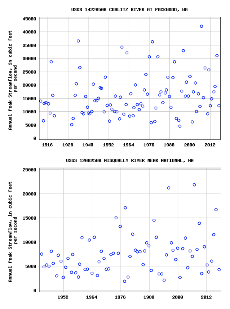 Figure 1: Annual peak streamflow for the Cowlitz River at Backwood (top) and Nisqually River near National (bottom) for their periods of record (from USGS).
This event caused major damage to roads, campgrounds, and buildings within Mt. Rainier National Park as the National Park Service reported 18” of rain fell within the park over November 6 and 7. Figure 2 shows the Nisqually River undercutting the foundations of buildings in Longmire. The National Park Service (NPS) initially estimated that the damage within the park totaled $36 million, but later revised that to $24-27 million. Still, the entire park was closed for 6 months as repairs were made, many by volunteers. In response to this damage and more flooding damage throughout the state, WA State Governor Gregoire requested federal disaster aid for 12 counties.
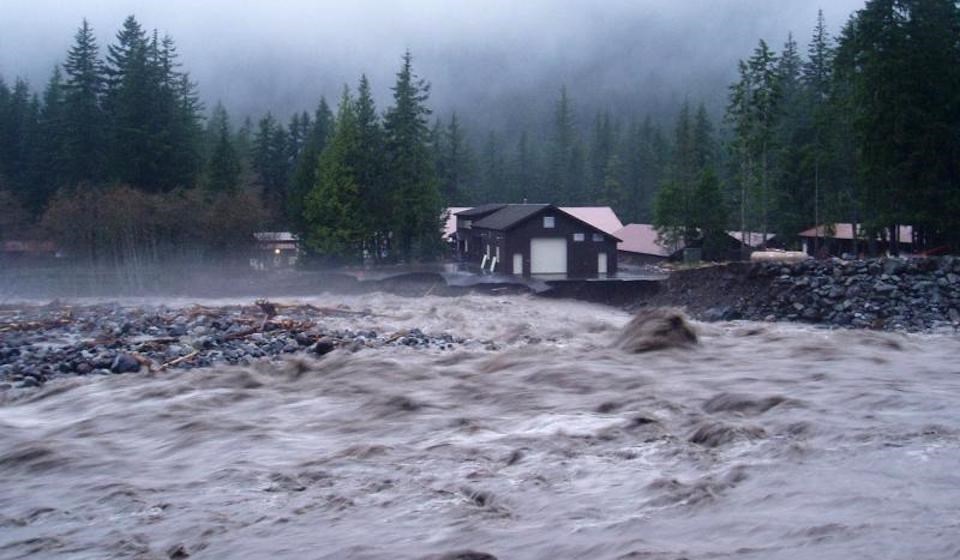 Figure 2: Nisqually River rushing past buildings in Mt. Rainier National Park during November 2006 flooding (photo credit: https://www.nps.gov/mora/learn/news/november-2006-flooding.htm).
The November 2006 flood is considered a highly unusual event for the region, and certainly not something we expect to see every year. Still, it’s important to recognize that there is potential for serious flooding in any year, despite the status of ENSO. Moreover, while there is also the weak tendency for fewer windstorms in El Niño winters, they still can, and do, happen in those conditions. A notable example occurred again in late 2006, specifically the Hannukah Eve Storm of December 14-15 that produced widespread damage and a number of fatalities in the Pacific Northwest.