By Nick Bond
Big weather events get a lot of attention for good reason. Our major rain, snow, and wind storms are noticed by everyone and can produce substantial monetary damages and safety risks. Episodes of black ice are much less dramatic, but arguably their impacts are disproportionate to the overall excitement that accompany them. To be fair, their importance is recognized by the Washington State Department of Transportation (WSDOT), which often pretreats roadways in threatening situations, and to an increasing extend by NWS and broadcast meteorologists. Nevertheless, it is still probably a rather ho-hum situation for the man/ woman in the street. But that changes in an instant once one loses traction, with your shoes or your tires!
A severe black ice episode that occurred in December 2008 led to a series of automobile accidents, with a fatality, in the Tri-Cities area. Another freezing fog incident in the following month caused 2 million dollars of damage to power lines in the eastern part of WA, principally Lincoln County.
These two events were noteworthy because of their severity but by no means is that typically the case. Much more commonly, temperatures can be marginal and fog is absent, leading to a very patchy distribution of ice. These situations are maybe even more insidious, in that a hazard may not be perceived. What kind of weather can lead to black ice? In brief, relatively clear and calm conditions that promote cooling of the surface, including roads and sidewalks, to the frost point. This tends to occur first and to greater extent in low spots in the local terrain, and on overpasses and bridges. It bears emphasizing that black ice can form when air temperatures (which are measured at 4-6 feet above ground) are above freezing; frosted windshield and lawns are often a good indicator of the possibility. Readers interested in a much more complete discussion of the factors determining the formation and distribution of black ice are encouraged to refer to a tutorial composed by Professor Cliff Mass and Rick Steed of the Department of Atmospheric Sciences at the UW (https://www.atmos.washington.edu/~cliff/Roadway2.htm).
Our purpose here is to look into the recent observational record for the type of weather associated with black ice, with a focus on the more severe events associated with air temperatures at 32°F and below. We consider two west-side stations, SeaTac (SEA) and Olympia (OLM), and two east-side stations, Spokane (GEG) and Moses Lake (MWH). Both daily and hourly data have been examined. The daily data has been used to identify the days during the cool season (October through March) during which there was a combination of minimum temperatures less than or equal to 32°F, heavy fog (visibility less than or equal to 1/4 mile) at some point in the day, and a lack of measurable precipitation. These days were considered to be those with the strong potential of freezing fog in the vicinity of the reporting station, and if not, conducive to the deposition of water vapor into ice on cold surfaces. The hourly data has been used to ascertain the number of hours per year with temperatures at 32°F and below, and the subsets of these hours that lacked precipitation (of trace as well as measurable amounts), and horizontal visibilities less than 1 mile, and less than 3 miles. The period of record considered is December 2007 through November 2012.
A chart illustrating monthly averages of the number of potential freezing fog days is shown in Figure 1. Note that SeaTac comes in a distant last in the frequency of these kinds of days. Olympia actually has more of them than Spokane and Moses Lake, especially in fall and late winter, even though its mean minimum temperatures are 3-10°F higher. SeaTac is a known local hot spot due to its location on a high bluff; the cold air that develops near the surface in those kinds of locations tends to drain away into nearby low-lying areas. Olympia is appreciated as one of the iceboxes of western Washington (Arlington is another one) due to its low elevation, and distance from the moderating influence of Puget Sound. Nevertheless, it may be surprising how often Olympia has experienced the combination of cold temperatures and fog. We also did not expect that Spokane would have more potential freezing fog days than Moses Lake. While the mean minimum temperatures during the winter months are comparable at the two sites, Spokane receives about double the mean precipitation, and so it might be surmised that cold weather is much more likely to be accompanied by snow. Moreover, Moses Lake is subject to the notorious “cold pool” that forms in the Columbia basin, with its attendant freezing temperatures, low visibilities, and poor air quality. Apparently this has not happened enough, at least during the last 5 years, to raise the threat of widespread, freezing fog/black ice events above that of Spokane. We were also struck by the large degree of year-to-year variability in the occurrence of these weather conditions (not shown). For example, during the month of December, Olympia has had as many as 12 of these kinds of days in 2011, and as few as 1 in 2007. We recognize the limitations of daily data, specifically involving the coincidence of fog and freezing temperatures, which motivated us to also examine hourly data.
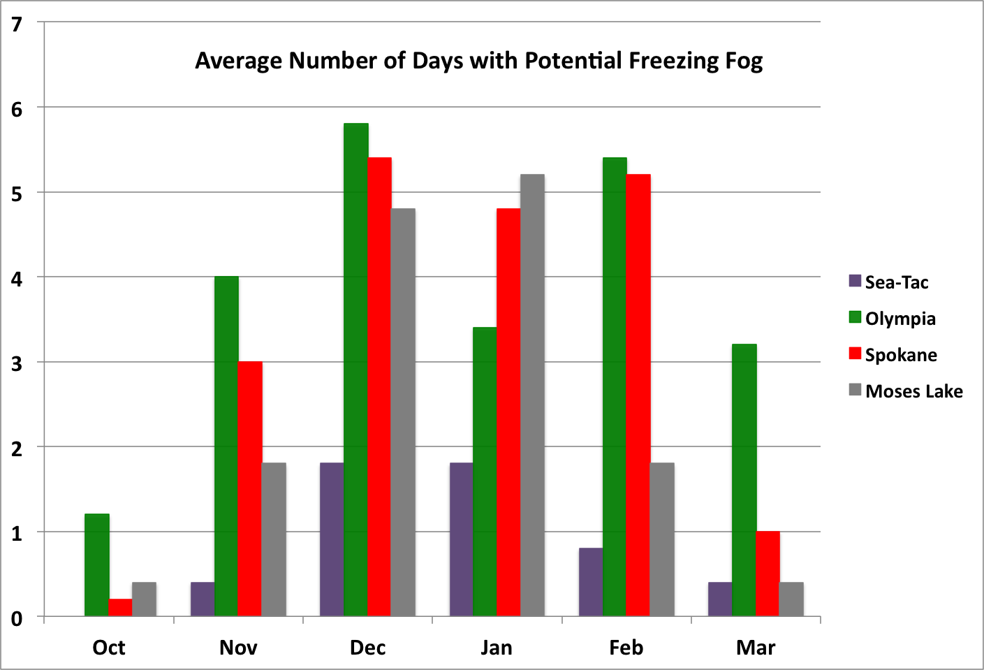 Figure 1: The average number of potential freezing fog days (temperatures less than or equal to freezing, heavy fog, and no measurable precipitation) for 4 WA locations. The averages are based on data from December 2007 through November 2012.
Averages of the number of hours per year with freezing temperatures at the four stations, along with other criteria, are shown in Figure 2. Again, SeaTac is the place to be if you hate cold temperatures, especially in combination with low visibilities. The latter conditions are generally associated with high relative humidities and hence better chances of significant icing. Olympia experiences roughly one-third as many hours of freezing temperatures as Spokane and Moses Lake, but a greater proportion of these hours are accompanied by lower visibilities. The result is something like 120-150 hours a year with the unholy trinity of freezing temperatures, no precipitation, and low visibilities/high relative humidities. Spokane and Moses Lake check in with about 1800 and 1650 hours of freezing temperatures, respectively. Of those totals, there has been precipitation during an average of about 150 hours a year in Spokane, and only 50 hours in Moses Lake. As also suggested by the daily data, the combination of freezing temperatures, lack of precipitation and low visibilities is considerably greater at Spokane than Moses Lake.
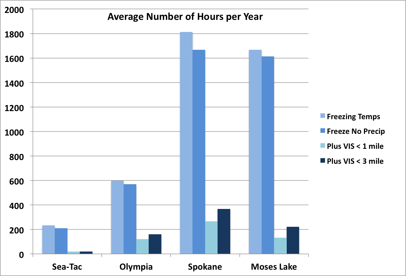 Figure 2: The average number of hours per year each station experiences freezing temperatures, freezing temperatures without any precipitation, freezing temperatures without any precipitation and visibilities less than 1 mile, and freezing temperatures without any precipitation and visibilities less than 3 miles.
The composite results shown here are intended to illustrate the frequency of the threat of significant black ice in various locations in WA. The results are not definitive; this would require a longer data record and a more sophisticated analysis. It is possible that inclusion of just the last 5 years, with the preponderance of La Niña, has skewed the results. A quick inspection of the data suggests that the weak-moderate El Niño winter of 2009-10 included fewer freezing days but not necessarily fewer freezing days with low visibilities, than the other years. It would be interesting to determine whether there are significant trends in the frequency of occurrence of freezing fog events, but again, that would require analysis of a longer data record and proper account for the large interannual variability. A final point worth repeating: while the present analysis has focused on the more severe conditions associated with air temperatures at or below freezing, black ice can occur when air temperatures are in the mid or even upper 30s, which is more common in the populated regions of Puget Sound. You can see for yourself whether such a threat exists by checking out roadway temperature maps provided by WSDOT at the following website: http://www.wsdot.wa.gov/traffic/Roadtemps/default.aspx.