By Nick Bond
Some folks have been remarking on how often it has been cold and sometimes snowy in February during the past decade or so. In part this can probably be attributed to the just-completed February of 2025, which has been the snowiest month of the winter for much of the state, especially at lower elevations on both sides of the Cascade Mountains. And the remarkable weather of February 2019 may still reside in many of our memory banks, even if the specific year it happened does not come immediately to mind. So it seems timely to determine whether February in recent years has actually been an unusually wintry month, and how the past decade or two stacks up with those earlier in the historical record. Towards that end, we consider both mean temperatures for the month of February and for the winter as a whole, and short time scale events, with a focus on snowfall in the two population centers of Seattle and Spokane.
Long-term air temperature records for WA state as a whole for the entirety of winter (defining the season in an inclusive manner to run from November through March), and for just the month of February, are shown in Figures 1 and 2, respectively. It should be no surprise that there has been an overall increase in winter air temperatures in WA state, with plenty of year-to-year variability (Fig. 1). A linear fit to the February temperature record results in the same temperature trend of about 0.2°F per decade (Fig. 2). Note the vertical scales of Figures 1 and 2 are different; the variability is greater for the February temperatures since there is less averaging. Although the long-term trend in February temperatures is clear, the trend seems to be almost non-existent over the last 4-5 decades. This is in contrast with air temperatures for winter as a whole, which show a clear increase in this time period. We simply have not experienced a really cold winter for quite some time. Moreover, while the warmer winters in the recent past have had mean temperatures comparable to those of the warmer winters in the distant past, we have a lot more warm winters now than before. But maybe there is something to the idea that February by itself does not fit the pattern for winter as a whole. February 2019 stands out as particularly cold, but many years since 2011 have had February temperatures below the average value for the 20th century.
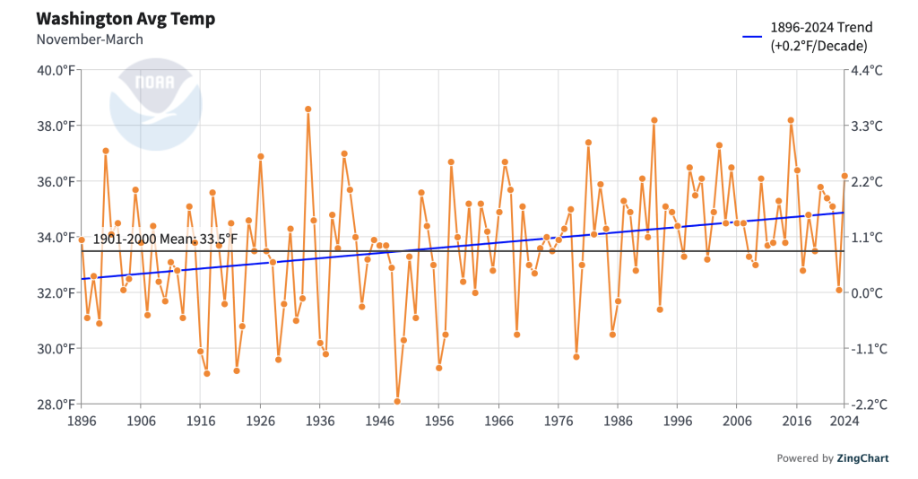 Figure 1: November through March average temperatures from 1896 to 2024 averaged across Washington. Linear trend lines (blue) and the long-term 1901-2000 average (black) are also included (NCEI Climate at a Glance).
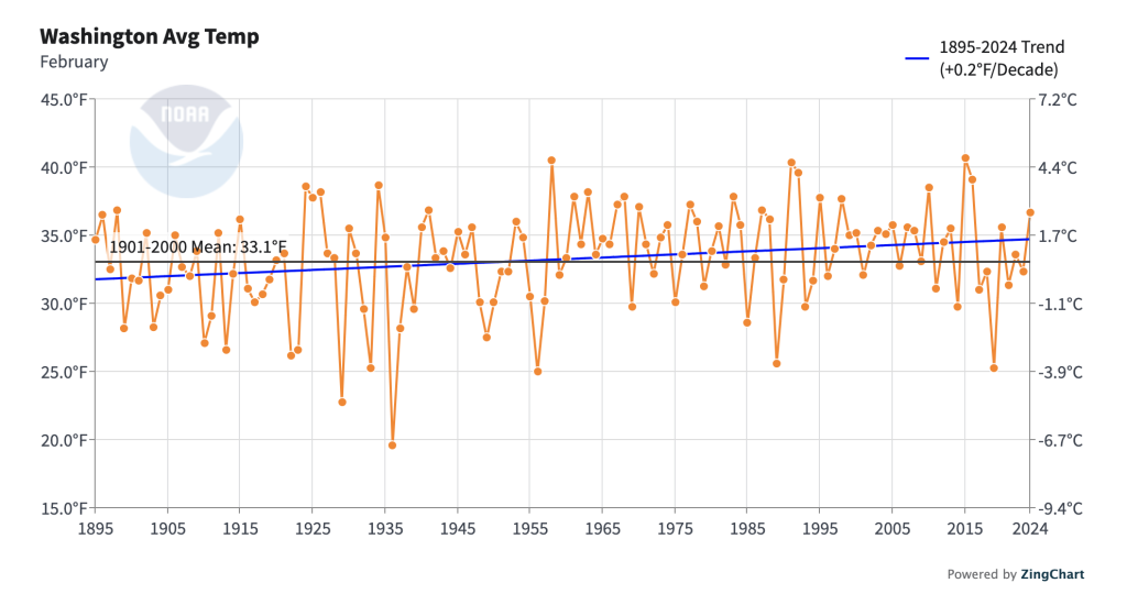 Figure 2: February average temperatures from 1895 to 2024 averaged across Washington. Linear trend lines (blue) and the long-term 1901-2000 average (black) are also included (NCEI Climate at a Glance).
We now turn our attention to snowfall in Seattle (as measured at Sea-Tac Airport) and Spokane (as measured at Spokane International Airport). First, considering Seattle, and winters as a whole (Fig. 3), what is striking are the two really big winters of 1949-50 and 1968-69, with nothing comparable in recent decades. There were numerous low snow years in the first half of the record, but there’s a hint that they are somewhat more frequent lately. With regards to the percentage of the winter snowfall in Seattle that occurred in the month of February, there is no clear trend. The notably snowy months in February of 2017, 2019 and 2021 dominated winter totals in those years, but given the variability in the record, those years appear to be a fluke. The snowfall record for Spokane (Fig. 4) is broadly consistent with that of Seattle. There is an overall downward trend in Spokane’s snowfall for winter as a whole, with the recent big years of 2008-09 and 2009-10 being exceptions. Considering the proportion of the total winter snow in Spokane falling in the month of February, an eyeball test suggests an overall increase, in part because of some sizable fractions in 2014, 2019, and the present winter of 2025. But again, we should be careful about “over-interpreting” a noisy time series. Either way, a handful of unusual years can impact climatological norms, generally defined in terms of 30 year averages. For example, at Seattle the month of February is the snowiest winter month in the 1991-2020 normals, with an average of 2.2 inches. For the overlapping period of 1981-2010, February averaged 1.7 inches of snow, which ties it with December as the snowiest winter month for that particular set of years. Worth noting: both sets include the stretch of years from 1997 through 2003 for which snowfall totals for Seattle are unavailable (annoying!).
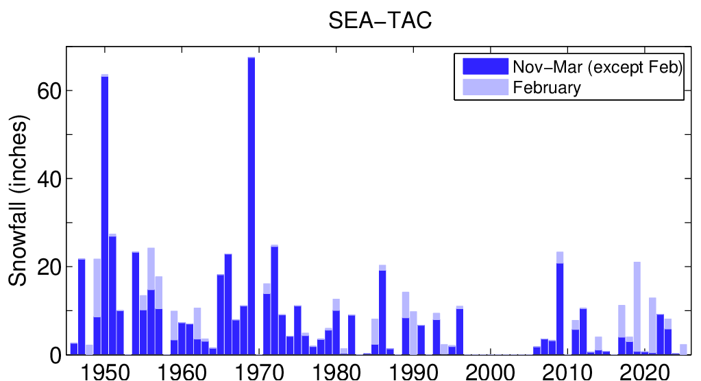 Figure 3: A stacked bar graph showing the total winter snowfall for November through March, excluding February (dark blue) and the total monthly snowfall for February (light blue) since 1945 at Seattle (SeaTac Airport). The light and dark blue bars together show the total winter snowfall from November through March.
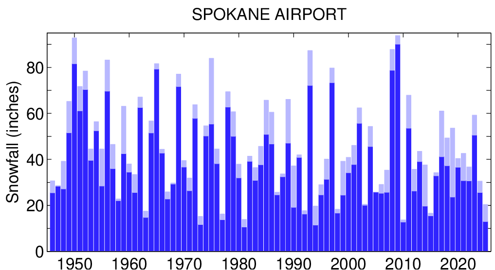 Figure 4: A stacked bar graph showing the total winter snowfall for November through March, excluding February (dark blue) and the total monthly snowfall for February (light blue) since 1945 at Spokane (Spokane International Airport). The light and dark blue bars together show the total winter snowfall from November through March.
Our primary intention has been to show how temperatures and snowfall have varied over past decades. But we did take a foray into why February recently has tended to include more snow. In particular, we took a look into how many days featured strong flow from the north. More specifically, for the location of 55° N, 125° W (in northern British Columbia), we determined how many days in February there was a northerly component of the flow in the middle atmosphere (at 500 mb) greater than 20 m/s. While it might seem arbitrary, this selection is motivated by the composite flow pattern at 500 mb associated with snowstorms in the Puget Sound area as documented by Ferber et al. (1993). They found that northerly flow at this location is associated with the development of a short-wave trough, and accompanying cold air, needed for most instances of lowland snow in Puget Sound. Although their analysis did not consider snowstorms in the Spokane area, often snowy periods in the Puget Sound area are also accompanied by cold weather in eastern WA. Using the NCEP reanalysis, we found that on average there are about 2 days each February with a northerly component meeting that criterion from 1960 through about 2017. Since 2017, the month of February has had about 4 days on average with northerly flow exceeding 20 m/s at 500 mb. Again, this is almost certainly more a short-term quirk rather than any sort of systematic shift in the regional circulation. Bottom line: while perhaps there is no harm in hoping, do not count on February being as wintry in future years!
Reference
Ferber, G.K., C.F. Mass, G.M. Lackmann and M.W. Patnoe, 1993: Snowstorms over the Puget Sound Lowlands. Wea. Forecasting, 8, 481-504. https://doi.org/10.1175/1520-0434(1993)008<0481:SOTPSL>2.0.CO;2