The Quality of CFS Seasonal Winter Predictions for the Pacific Northwest
Seasonal weather predictions are based increasingly on global climate model output. They have been evaluated for the tropical Pacific and other very large (continental scale) regions, but less is known about the quality of these predictions for specific regions such as the Pacific Northwest. This is a timely issue from a local perspective. The fall and early winter of 2013-14 was remarkably dry in Washington state; can these sorts of climate events be predicted with any reliability?
We might be in luck, at least relative to many other parts of the globe. As many readers of this newsletter are probably already aware, there are systematic effects on our weather associated with the El Niño-Southern Oscillation (ENSO), and the present suite of global climate models used for seasonal weather forecasting have meaningful skill at ENSO prediction out 6-9 months. But what does this imply in concrete terms about the forecasts for our region? Some recent research undertaken under the auspices of the coastal ocean prediction system called J-SCOPE (highlighted in the Sept 2013 newsletter) is relevant to this question. We hasten to emphasize that this is just a quick look at some aspects of the skill of seasonal forecasts from a regional ocean forcing perspective, and is therefore more illustrative, rather than anything close to a comprehensive analysis.
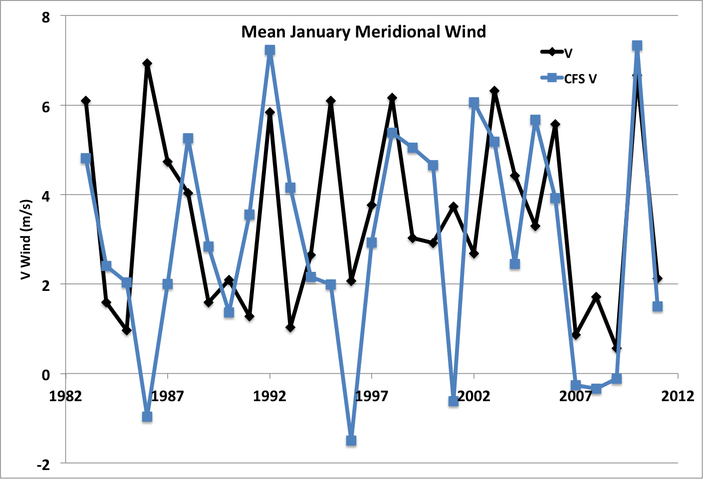
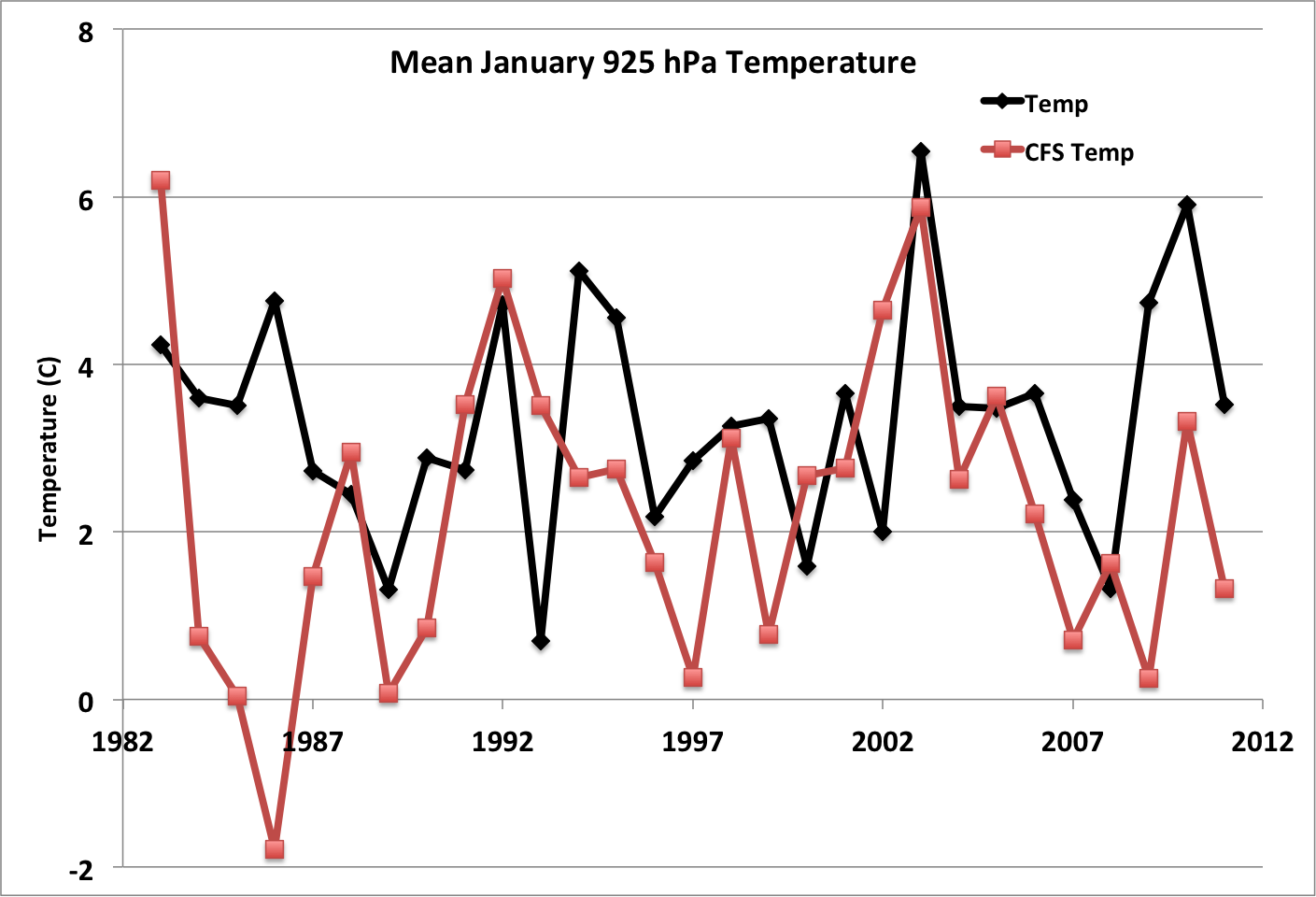
The analysis was based on re-forecasts from the Coupled Forecast System (CFSv2) model (Saha et al. 2006) from NOAA’s National Center for Environmental Prediction (NCEP). The re-forecasts are simulations from a global atmosphere-ocean model that includes only the data available at the time of initialization, and hence mimic the information available and procedure of the operational forecast model runs of the CFSv2. The re-forecasts for the period of 1982-2011 are considered here. Two sets of 6-month forecasts were examined for J-SCOPE: model predictions made in January for the following July as a whole, and predictions made in July for the following January. The analysis was restricted to selected parameters important to the forcing of the coastal marine ecosystem. Here we show results of CFSv2 model predictions made in July for the following January fortwo parameters: the north-south component of the surface winds over the coastal waters averaged over a box extending from 43-49°N and 128-124°W, and 925 hPa air temperatures in the coastal region of 43-49°N and 125-121°W.
The 6-month forecasts of the winds (Figure 1) are superior to those of 925 hPa (atmospheric boundary layer) air temperature (Figure 2) in the overall sense. The correlation between the forecasts and observed conditions are 0.39 and 0.21 for the winds and temperatures, respectively. The majority of the forecasts are good and some are excellent, but there are a few real clinkers. There is some indication of an improvement with time, presumably to the availability of more or different observations for model initialization, since the same model is used for the entire period. But there was also a recent bust. The winter of 2008-09 included a weak-moderate La Niña, and while the model correctly predicted the suppressed southerly winds, as is usually the case during La Niña, it also forecast a colder than normal temperature in January 2009, during which it was actually relatively warm (it was cold and snowy in December 2008). It turns out that CFSv2 model skill is higher for PNW forecasts made in summer for the following winter than those made in winter for the following summer. In other words, perhaps we can better anticipate the winter weather for skiers than coastal marine habitat in summer for juvenile salmon.
A similar type of analysis has not been carried out for precipitation, and so here we cannot say much about the aforementioned dry stretch during October 2013-January 2014. Review of past model forecasts from the CFSv2 during early fall 2013 for precipitation were a mixed bag. Some of the forecasts, but by no means all, indicated that it would be relatively dry over the period, but generally not to the extent that was observed. More consistency was provided by the National Multi-Model Ensemble (NMME) and the International Multi-Model Ensemble (IMME). The forecasts made by NMME and IMME last fall for early and middle of past winter indicated the right sense of the precipitation anomalies if not the extreme magnitude. As in short-term weather forecasts, a multi-model approach is generally preferable, and the recent predictions for our seasonal weather are no exception. It is worth mentioning that global climate models cannot be expected to replicate small scale (mesoscale) variations in precipitation since their coarse resolution prevents proper account of the effects of regional terrain.
Reference:
Saha, S., and Coauthors, 2006: The NCEP Climate Forecast System. J. Climate, 19, 3483-3517.