By Nick Bond
The Pacific Northwest experienced a period of seasonally quiet and dry weather from October 2013 into February 2014. This period also featured anomalously weak cooling of the upper ocean off our coast for the time of year. The result was what will hereafter be referred to as the “blob”, a large mass of water that was ~3°C warmer than normal in February 2014 and is still prominent (Figure 1). Ocean temperature anomalies have the potential to affect the thermodynamic properties of the low-level atmosphere over Washington state, especially if regional circulation anomalies are not prominent. So could the blob potentially impact our summer weather? It is expected to hang around, and may even be reinforced by the El Niño that appears to be developing.
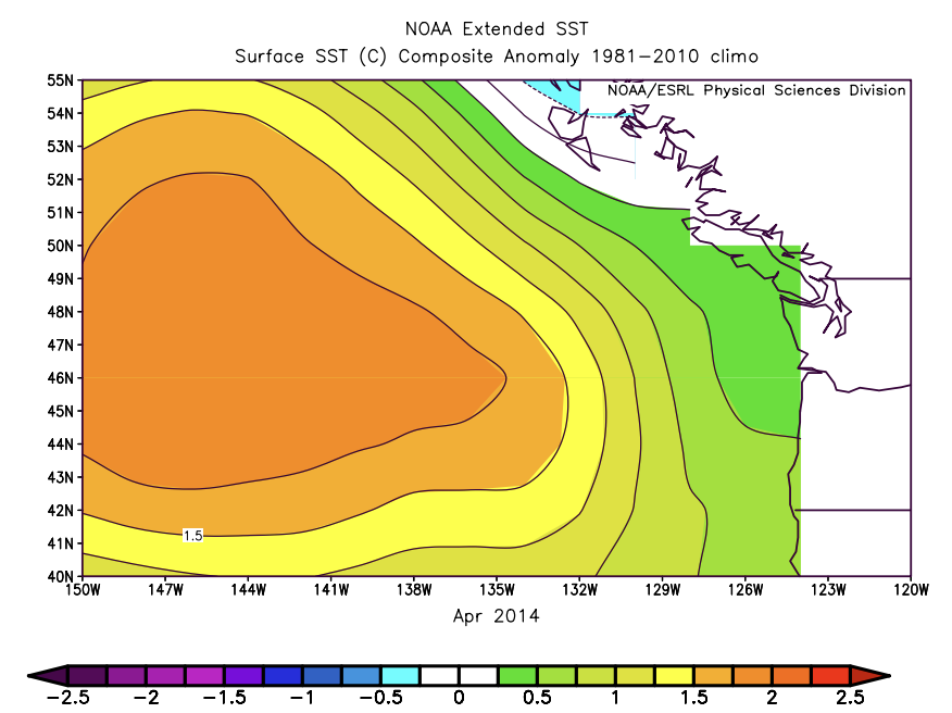 Figure 1: The SST anomaly pattern (compared to 1981-2010) off the coast of Washington and Oregon for April 2014 (from ESRL).
The dry weather in the Pacific Northwest during the fall and early winter of 2013-14 involved much higher than normal pressure over the eastern North Pacific Ocean, as illustrated in the sea-level pressure (SLP) anomaly map shown in Figure 2 and discussed in previous issues of this newsletter. This pattern meant fewer and weaker storms making landfall into our neck of the woods (and rather cold weather east of the Rocky Mountains). From an upper ocean perspective, a key aspect was weaker than usual westerly winds. The consequence included reduced surface sensible and latent heat fluxes, less mixing of cold water from below into the upper mixed layer, and reduced equatorward Ekman transports (i.e., less cold advection in the mixed layer). All of these mechanisms acted in a similar sense. As an aside, OWSC is participating in an ongoing project to evaluate the relative contributions of the different mechanisms using moored buoy and hydrographic observations from a Canadian research ship.
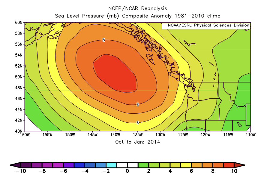 Figure 2: The mean SLP anomaly pattern (compared to 1981-2010) for Oct 2013 through Jan 2014 (from ESRL).
The blob may strengthen due to El Niño, particularly if the eastern equatorial Pacific continues to warm over the next couple of months. A time series of SST in the region of the blob (Figure 3) shows that past instances of abnormally warm water off our coast have tended to occur with El Niño. That being said, as shown in Figure 3, there have been a number of El Niño events that formed by late summer that were accompanied by near normal or even somewhat chilly SSTs. While there are certainly no guarantees, a strong consensus of the global climate models used for seasonal weather prediction is that the SSTs in the region of the blob will continue to be well above normal during the late summer of 2014. And that could have implications for not just the marine ecosystem but also our weather.
It has tended to be relatively warm and rainy during previous August-September periods during which exceptionally warm water was present off our coast, as shown in composite maps for the 6 years with the highest SST (Figure 5). We are not claiming that the regional SST was necessarily the primary cause, or even a critical factor, in the late summer weather of those years. They included mean negative SLP anomalies off the coast of up to ~ 3 mb and weak southerly wind anomalies of ~1 m/s off the mouth of the Columbia (not shown). Presumably these pressure anomalies, and associated winds were more due to a remote response to El Niño rather than a local response in the circulation to the underlying SST. The teleconnection or “atmospheric bridge” between the equatorial Pacific and the northeast Pacific is generally weaker in summer than in winter, but El Niño does tend to be associated with regional circulation anomalies. The bottom line is that the presence of warm SSTs, and the climate model forecasts of their continuation, supports the idea that the Aug-Sep period will be warmer than normal, as also indicated by the climate models as a group. It would also seem that the warming and moistening of the low-level atmosphere that is liable to occur this summer will also favor the development of more thunderstorms than usual. Perhaps it was just a coincidence, but the late summer of 2013 featured both very warm SSTs and enhanced convection. So perhaps we can look forward to some of that kind of weather, recognizing that the atmosphere always has some tricks up its sleeve.
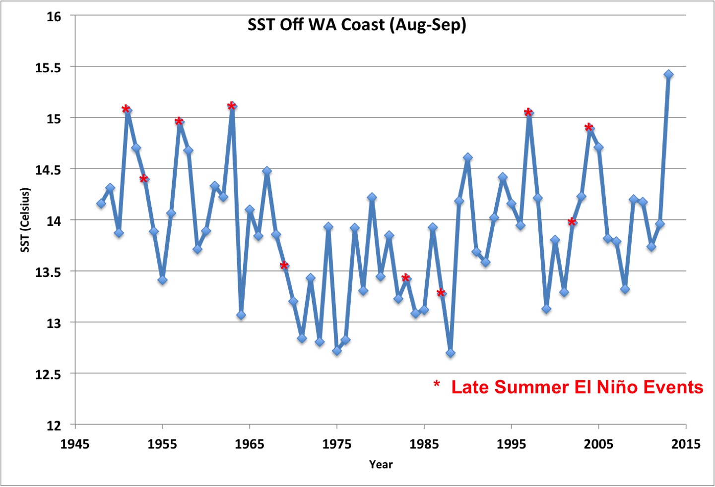 Figure 3: Mean August-September SSTs for the region of the blob from 1948-2013. The red asterisks represent years in which an El Niño had already developed by late summer.
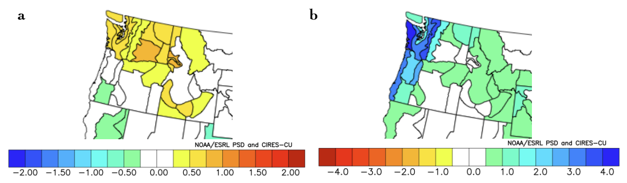 Figure 4: The mean (a) temperature and (b) precipitation patterns for previous Aug-Sep periods with warm SST anomalies off the coast.