By Nick Bond
There are two basic types of meteorological forecasts. On shorter time scales, present atmospheric conditions can be used to predict spatial and temporal details in the evolution of the atmospheric flow and associated weather. Current generation numerical weather prediction (NWP) models typically demonstrate considerable skill out 3-7 days (e.g., Bauer et al. 2015), with large improvements in skill made over the past 4 decades (Figure 1). On longer time scales, months to about a year, forecasts key on mean patterns accompanying slowly varying boundary conditions for the atmosphere, such as sea surface temperature and soil moisture. Characterization of the temporal variability in the circulation and weather is not feasible beyond the period when initial atmospheric conditions play a dominant role. That leaves a gap between short-term weather forecasts and longer-term seasonal projections.
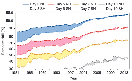 Figure 1: Skill (%) in 3-, 5-, 7-, and 10-day ECMWF operational model forecasts of 500 hPa geopotential height distributions for the northern (NH) and southern (SH) hemispheres from 1981 to 2014. Improved assimilation of satellite data is responsible for the relative increase of skill for the SH shown on the graph after 1999 (from Bauer et al. 2015).
A new product from NOAA’s Climate Prediction Center (CPC) attempts to bridge that gap. Experimental forecasts of temperature and precipitation for the U.S. for week 3-4 are now being provided by CPC. These forecasts are updated once a week on Friday afternoon and are posted on the following website: http://www.cpc.ncep.noaa.gov/products/predictions/WK34/. A recent example is shown here (Fig. 2). The information consists of the expected distributions of the anomalous temperature and precipitation for the 3 to 4 week period as a whole in the three-tier format used for the seasonal forecasts. A forecast discussion is included. As indicated in these discussions, the basis for the forecasts includes output from ensembles of extended NWP model simulations from the European Centre for Medium-Range Weather Forecasting (ECMWF), the Japan Meteorological Agency (JMA) and NOAA’s Center for Environmental Prediction (NCEP). Consideration is also given to the present state of slowly varying components of the atmosphere-ocean-land system, with El Niño representing an important contribution currently. In addition, these forecasts exploit the Madden-Julian Oscillation (MJO), which represents a major source of variability in the tropics on 40-60 day time scales. The MJO often has some predictability out a few weeks; the phase of the MJO exhibits teleconnections with the weather at higher latitudes, including the Pacific Northwest (Bond and Vecchi 2003).
It remains to be seen how much useful skill these 3-4 week forecasts will have in a real-time setting. The truest test of forecasts is in true predictive mode without the benefit of hindsight, which is what is being done with this product release. Moreover, the lessons learned from carrying out these forecasts should help show which factors are most important in different situations, and ultimately how these kinds of predictions can be improved. We are interested in the weather on this time scale, of course, and are curious about just how well it can be anticipated.
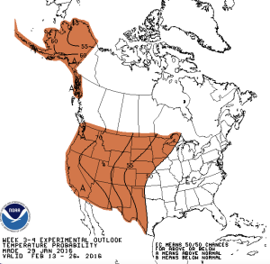
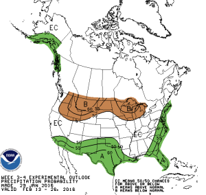 Figure 2: The 3-4 week experimental outlook for temperature (top) and precipitation (bottom) made on January 29, 2016 and valid for February 13-26 from the Climate Prediction Center.
References:
Bauer, P., A. Thorpe, and G. Brunet (2015): The quiet revolution of numerical weather prediction, Nature, 525, 47-55.
Bond, N.A. and G.A. Vecchi (2003): The influence of the Madden-Julian Oscillation on precipitation in Oregon and Washington. Wea. Forecast, 18, 600-613