By Karin Bumbaco
Now that our nights are getting longer and that familiar fall chill is in the air, folks are beginning to wonder what to expect for the upcoming 2016-17 winter. The El Niño of winter 2015-16 has been long gone, and neutral ENSO (El Niño-Southern Oscillation) conditions took its place this past summer. Initially, it looked as if La Niña would develop, but the likelihood of that occurring has decreased. Instead, models are showing higher chances of neutral conditions continuing. At the time of this writing, the Climate Prediction Center/International Research Institute (CPC/IRI) ENSO forecast has a probability of neutral conditions for December through February of 56% while the chances of La Niña for this same time period are 36% (remaining 8% is chance of an El Niño).
Neutral ENSO years don’t typically give us a lot of foresight into the upcoming winter, but can still provide some clues. Average October through March precipitation statewide for historical neutral years from 1933 through 2014 is only slightly less than the average of all years (illustration). Looking at 11 neutral ENSO years since 1980 indicates wetter than normal (1981-2010 average) conditions for the heart of the winter season – December through February – in most of Western WA (Figure 1). Precipitation anomalies are between 0.50 and 1.50” for the climate divisions in western WA, but near-normal for Eastern WA and the Olympic Peninsula. As for temperature, those same 11 neutral ENSO years have near-normal temperatures (within 0.5°F of normal) on average for December through February (Figure 2). It is important to recognize that there is of course variability in the seasonal averages and totals from one neutral year to another. For example, the Dec-Feb temperature anomaly, precipitation anomaly, and April 1 snow water equivalent for the last two ENSO-neutral years are shown Table 1. Average temperatures for 2012-13 were near-normal while temperatures were on the cooler side in 2013-14. Perhaps more interesting is that averaged statewide, both years had below normal DJF precipitation but ended the season with near-normal snow. This is great news for those that have been adversely impacted by drought in WA over the last few years.
 Figure 1: December-February precipitation composite of neutral years from 1980-present (from ESRL).
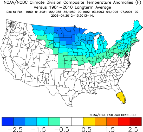 Figure 2: December-February temperature composite of neutral years from 1980-present (from ESRL).
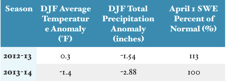 Table 1: Statewide average temperature and precipitation during our last two neutral years. Normal is the average over 1981-2010.
Besides examining analogs in mean winter conditions, what do we know about weather events during neutral years? The short answer is unfortunately not that much; a good rule of thumb is to prepare for the usual winter storm events as there has been plenty of variability throughout past neutral years. Take wind storms, for example. While some of our strongest and most memorable named storms occurred during ENSO-neutral years (e.g., 1962 Columbus Day Storm, 1993 Inaugural Day Storm, etc.), there are some that occurred during a positive phase (e.g., Dec 2006 Hanukkah Eve Storm) or negative phase (e.g., Dec 2007 coastal wind storm) of ENSO as well. Furthermore, analyzing the top 0.1% of hourly winds at various stations across WA indicated that there is actually a higher likelihood of wind events of that magnitude during La Niña winters at many stations. For lowland snow, there is little indication that there is increased or decreased likelihood during a neutral year, but mountain snow is typically near-normal for neutral years. What about floods? Once again there isn’t clear relationship between the neutral phase and flooding, since there have been both neutral years with few floods and those with major floods. That being said, there appears to be a tendency for some basins to experience their worst flooding in neutral years. Given that some river flooding occurs virtually every winter, folks definitely should be prepared for this kind of event.
Even though past neutral years can provide insight into the types of winters we have experienced before, it’s best to rely on seasonal climate model predictions for how this winter will turn out. The North American Multi-Model Ensemble (NMME) averages several seasonal forecast models to provide an ensemble forecast. The forecast for December-February shows wetter than normal conditions and warmer than normal temperatures (Figure 3) for the state of WA. There is a higher probability of warmer than normal temperatures (between 50-60%) than for wetter than normal precipitation (40-50%; not shown). We will continue to monitor the forecasts over the next two months. The official forecast from the Climate Prediction Center takes this seasonal climate model output into account, and is discussed in the “Climate Outlook” section below. 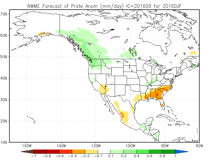
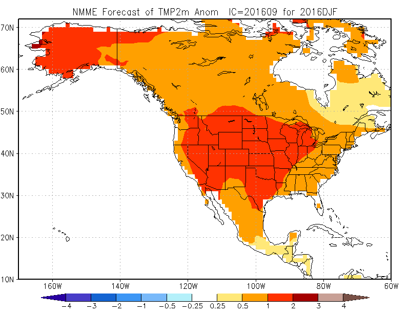 Figure 3: The NMME December-February forecast for precipitation (top) and temperature (bottom).
An additional factor is the sea surface temperatures on our coastal waters. Sea surface temperatures remain considerably warmer than normal across most of the NE Pacific Ocean, and it is likely that this will continue to be the case through the upcoming fall and winter, with the largest positive anomalies in a wide band along the west coast of North America. The presence of this warm water stacks the deck for warmer than normal winter temperatures, particularly in western WA.
In summary, it is likely that ENSO neutral conditions will last through the winter, although the development of a weak La Niña is possible. A composite of the last 11 neutral years shows near-normal seasonal averages for both temperature and precipitation for a majority of the state for Dec-Feb. There is some tendency for it being wetter than normal in Western WA, but these composites are not the whole story in that a wide range of seasonal mean conditions have occurred in WA during neutral years. For the upcoming winter of 2016-17, the projections out of the NMME models are indicating both warmer and perhaps wetter than normal conditions for this coming DJF, which differs from the past analogs. The bottom line is to prepare for the possibility of winter storms; a good resource to help you prepare can be found at the Take Winter By Storm campaign.