By Nick Bond
We have made it through the month of June and so now we can expect generally warmer weather in Washington state. Most everybody who has lived here longer than a year or two appreciates that this is the case, but perhaps it is not obvious why. After all, the summer solstice has passed, meaning the days are getting shorter and the sun is getting lower in the sky (albeit slowly). So our warming cannot be tied directly to the tilt of the earth’s axis of rotation relative to the sun. Moreover, the timing of the warmest temperatures in a climatological sense varies substantially across the United States, as illustrated in a map produced by the National Center for Environmental Information (NCEI) reproduced here as Figure 1. Based on daily maximum temperatures recorded during the years of 1981-2010, the hottest time of the year tends to be earlier in the desert Southwest and Midwest, and later in the south-central and northwestern US. The warmest days in the immediate vicinity of the west coast are particularly late in the summer season.
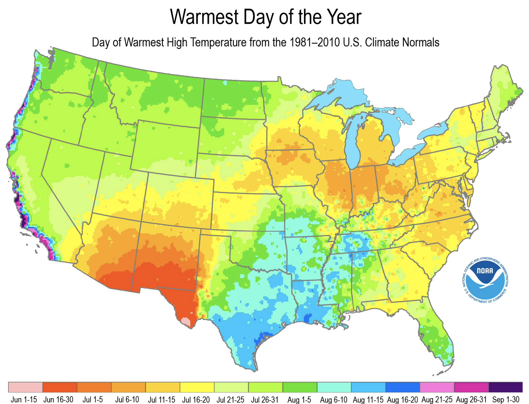 Figure 1: Warmest day of year across the US (see legend at bottom of map)
The pattern in the mean date of the warmest day shown in Figure 1 is liable to be attributable to sub-seasonal differences in the atmospheric circulation, at least for the western US. This contention is based on the mean 500 hPa geopotential height (Z) distributions for a 10-day period centered on the end of June (Fig. 2a) and the end of July (Fig. 2b). At first blush, the two distributions may appear rather similar. Each includes a mean ridge of higher Z extending from New Mexico northward through eastern Montana and southwesterly flow off the Pacific into the coastal states. But there are some important distinctions. The mean values of Z are higher across the whole domain, with a high center over or near New Mexico (generally termed the Four Corners high). The latter feature is associated with relatively frequent intrusions of moist air, usually from the southeast. The upshot is markedly higher humidity and more clouds, and much more frequent thunderstorms for the desert southwest. There is a saying for the region that the “fireworks start after the 4th of July”. The transition in the desert southwest from mostly clear to cloudier skies which typically occurs in early July explains the decline in mean daytime temperatures. We hasten to point out that does not imply a return to pleasant conditions. For example, mean maximum temperatures in Tucson, Arizona are still in the high 90s F in the latter part of July, and are exacerbated by dew point temperatures typically near 60 F.
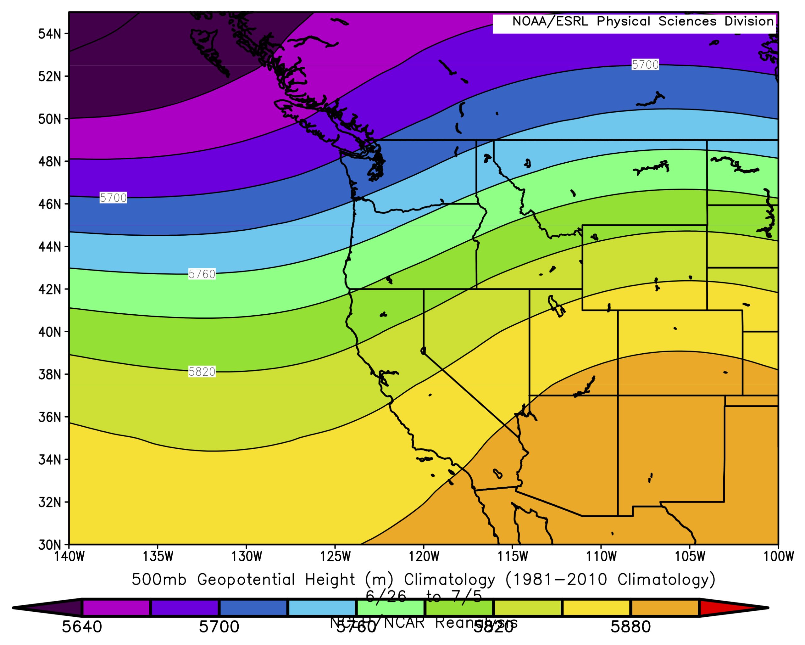 Figure 2a: Mean 500 hPa geopotential height (Z) during June 26 through 5 July based on a 1981-2010 climatology.
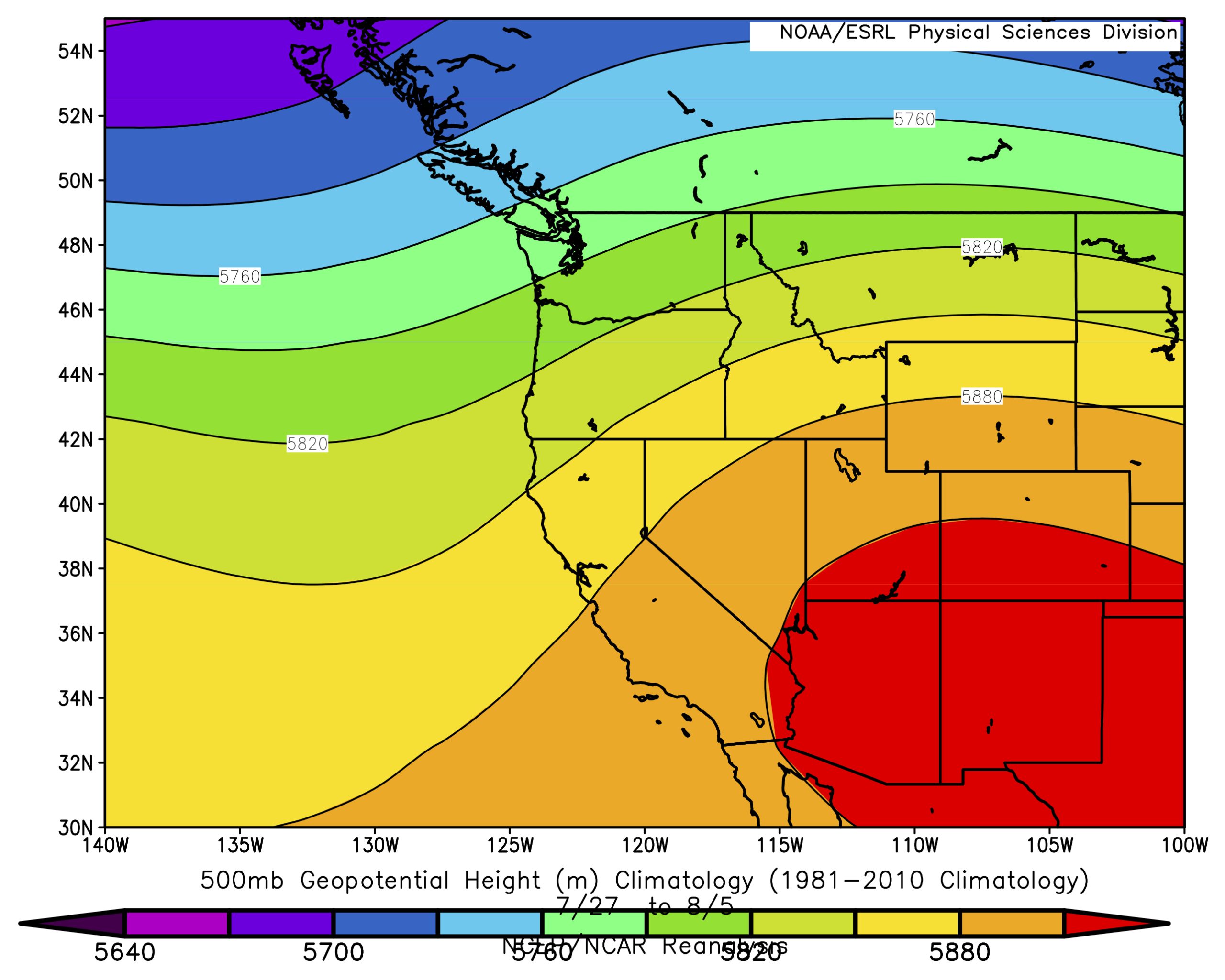 Figure 2b: As in Fig. 2a, but for July 27 through 5 August
The onset of the rainy season for the desert southwest more or less coincides with drier weather for the Pacific Northwest. The increase in overall values of 500 Z that tends to occur early in summer means fewer and weaker short-wave troughs moving into the area from the west and hence more settled weather conditions. Across WA state, the average 500 Z during days of rain (1 mm or greater) in the months of June through September is approximately 5680 decameters; days with 500 Z below this value are considerably more likely in June than in July and August (not shown). In other words, the decline in the frequency of rain around here in early summer helps account for warmer maximum temperatures in the mean. What does not really matter is the magnitude of the difference in sea level pressure (SLP) between the ocean and inland portion of WA. The mean difference in SLP between the coast and Columbia basin is actually slightly greater during the months of July and August as compared with June. There is a northward shift in the latitude of the lobe extending northeast from the center of the subtropical high over the North Pacific. The highest pressure at the coast is off the mouth of the Columbia River in June and off Vancouver Island in July and August (not shown).
This subtle change results in a transition to more northwesterly low-level flow in early to middle July. This set-up tends to include sinking motion, leading to clearer skies and warmer afternoons. In quantitative terms, the mean sinking motion at 700 hPa (about 3 km) over WA is about three times greater during the end of July than the end of June. Of course there are exceptions to these seasonal trends. Examples here include 1993, when June- like weather extended into July for the Pacific Northwest, and recently, in 2015, which featured a particularly early start to summer and a host of maximum temperature records in June. What about 2017? Our hindsight is superior to our foresight, but at the time of this writing, it looks like summer is arriving on schedule. It had better, since many of us are counting on home-grown tomatoes.