By Jacob Genuise
March was an eventful month for snowpack due to a steady and large increase in snowpack in the middle of the month followed by significant melt-out due to the March 25-26th warm spell. When all was said and done, snowpack stayed largely steady this month when measured as a percent of 1991-2020 SWE. The Central Puget Sound watershed still shows the lowest percent of median (67%) while the rest of the central and northern Cascades have 70-80% of median SWE. The Southern Cascades, Blue Mountains, and the Northern Rockies in northeast WA have near or just above normal snowpack as of April 1st.
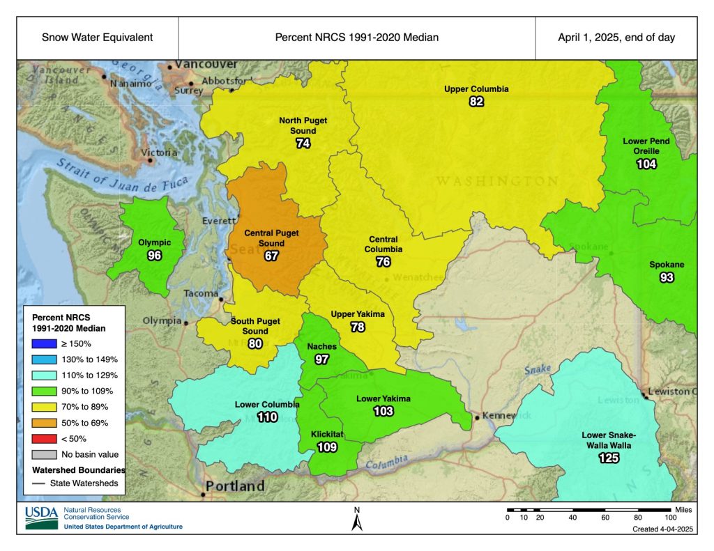 Snow Water Equivalent (SWE) percent of 1991-2020 median as of April 1, 2025. Source: NRCS.
This graph of SWE shows just how dynamic the month of March was for mountain snowpack. The month started off with generally settled weather and only light precipitation, as seen in the flattened portion of the SWE graph below at the beginning of the month. Then, numerous wet and reasonably cool weather disturbances brought ample snowfall to the mountains from roughly March 10-24. This snowpack temporarily brought the statewide SWE to near the 1991-2020 median on March 24.
However, very warm conditions began to build into March 25, and snow melted rapidly as a result. Around 4 inches of SWE was lost over the course of March 25-28 when averaged across all SNOTEL stations in the state.
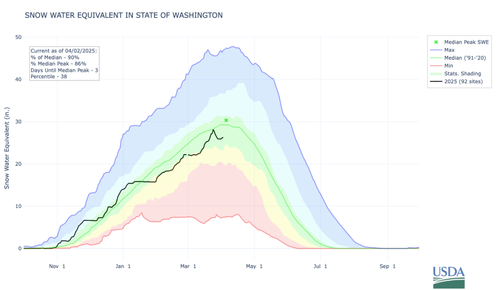 Snow water equivalent for all Washington State SNOTEL sites. Source: NRCS.
Multi-year Drought Pressure and April 8, 2025 Drought Declaration
There is still some time for us to see additional spring snowpack increases, but we are most likely to come in just a bit below our 1991-2020 normal SWE for the winter season statewide. Although these slightly drier-than-normal conditions are not much cause for concern on their own, they come on the heels of last year’s even larger snowpack deficit. Last year’s limited water resources strained important reservoirs including, most notably, reservoirs in the Yakima Basin which are still largely under 50% full. The U.S. Bureau of Reclamation total water supply forecast for April-September, made on April 3, is for proratable water users to only receive 58% of their total water allotment. With the Governor’s approval, the Washington Department of Ecology extended last year’s drought declaration in Yakima, Kittitas, and portions of Benton Counties on April 8, 2025. The new drought declaration will expire on April 7th, 2026.
To get a better sense of these longer-term water deficits we can look at the Standardized Precipitation Evapotranspiration Index (SPEI) over the past two years. SPEI is a measure of the difference between precipitation and evapotranspiration (“evapotranspiration” measures water loss from both evaporation and transpiration by vegetation) relative to normal. Negative values of SPEI (shaded in red on the 24 Month SPEI map) indicate there has been more water lost to evapotranspiration than water gained to precipitation than usual over the period. In other words, negative values point to drier-than-normal conditions. Large areas of the Cascades and western foothills of the Cascades show a deficit over the past 24 months.
This is a great example of how drought cannot always be attributed to a single year alone, but that back-to-back mildly to moderately dry years can exacerbate dry conditions and require a longer period of time for recovery. Notably, multi-year drought has been historically rare in Washington – we generally expect our wet winters to replenish our water supply each year.
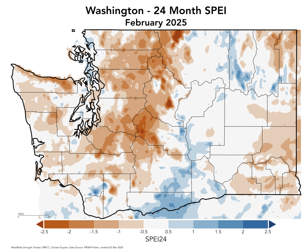 24 Month (February 2023-February 2025) Standardized Precipitation Evapotranspiration Index (SPEI). Source: West Wide Drought Tracker
Moderate Drought conditions (D1) remain across the Cascade Mountains and western foothills of the Cascades according to the U.S. Drought Monitor. Abnormally dry conditions exist across much of Puget Sound, the periphery of the Cascades, and small portions of Pend Oreille County, but drought conditions are absent in these areas as of April 1, 2025.
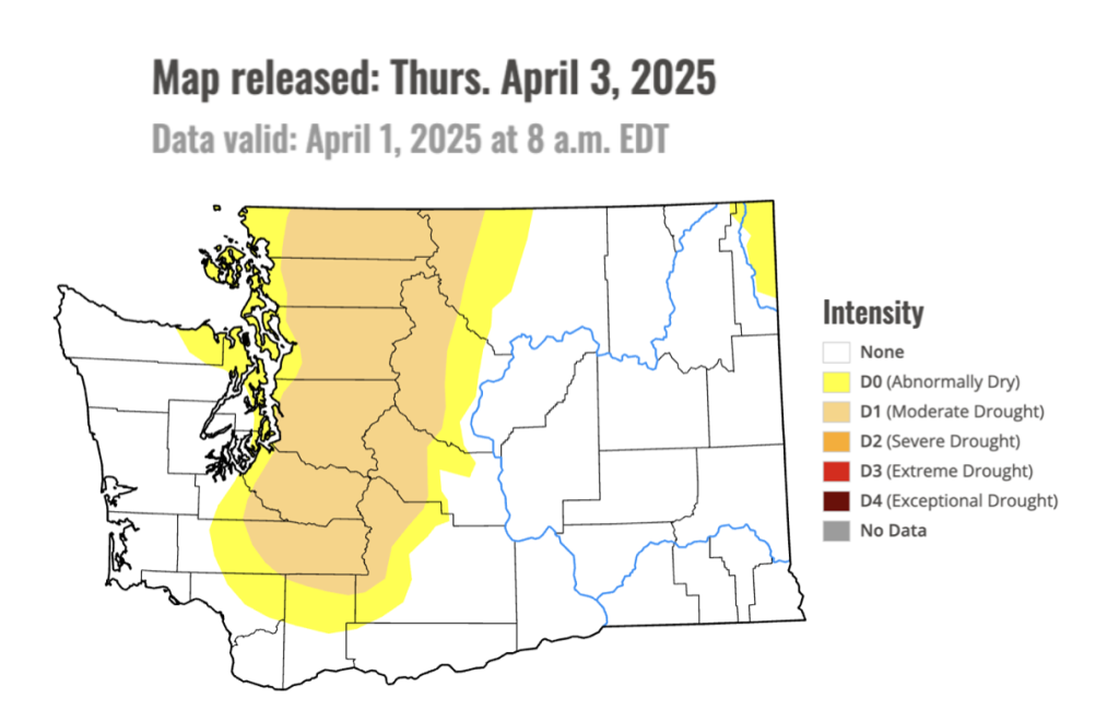 Drought conditions in Washington State as of April 1, 2025. Moderate Drought (D1) conditions exist across the Cascade Mountains and the western foothills of the Cascades. Source: U.S. Drought Monitor.
Finally for some good news, beneficial rain and snow throughout the month has eliminated Moderate Drought conditions in the northwest Olympic Peninsula and eliminated all abnormally dry conditions in southwestern Washington. Abnormally dry conditions were also removed in the Blue Mountains of southeastern Washington this month. Green shaded areas on theU.S. Drought Monitor Class Change map indicate these areas of improvement while gray areas show no change in drought classification from March 4 to April 1, 2025.
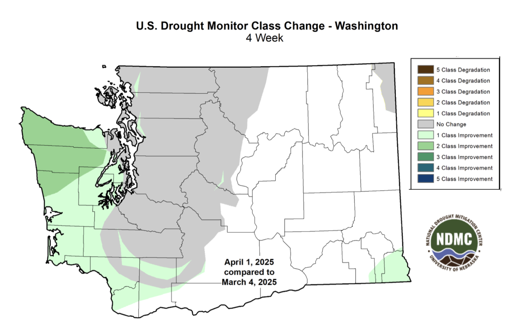 Change in U.S. Drought Monitor classification from March 4 to April 1 2025. Drought improvement has occurred in the Olympic Peninsula, southern Cascades, and the Blue Mountains. Source: U.S. Drought Monitor.