By Jacob Genuise
 Observed daily high and low temperatures (dark bars) as well as records and normals (background shading) for SeaTac Airport (left) and *Spokane International Airport (Right). *Spokane’s graphic is missing data from April 28-30. Source: NWS Seattle, NWS Spokane.
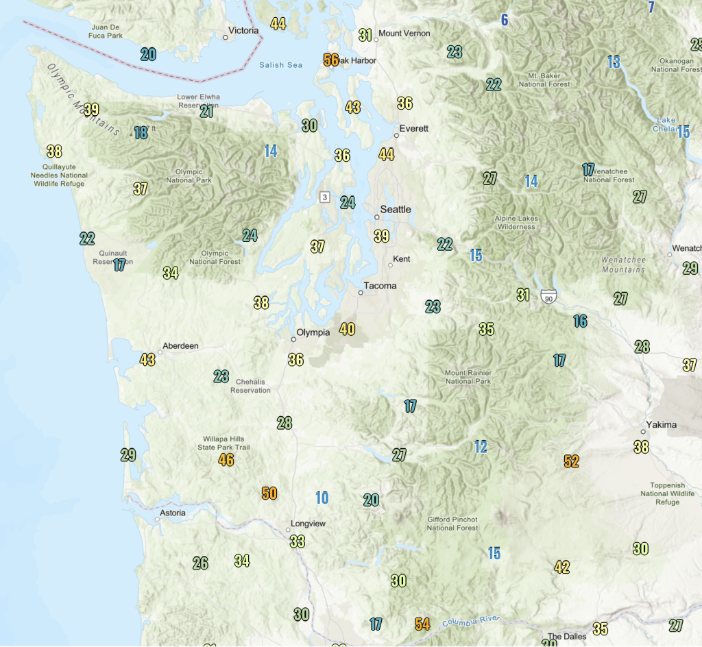
April 2025 featured above average temperatures and below average precipitation. The bulk of this month’s rainfall fell from April 6-10 as an active weather pattern impacted primarily western Washington and the Pacific Coast. A CoCoRaHS observer near Quinault recorded 4.45” of rainfall for this 5-day period, and another observer in Wahkiakum County (far southwestern Washington) recorded 3.93” of rainfall during this same period. Some light rain did manage to make its way east of the Cascade Crest, primarily on April 7th when around 0.25” fell in and around the Spokane metro and around 0.10-0.20” fell elsewhere in eastern Washington. Otherwise, much of eastern Washington experienced a very dry April.
 Statewide rainfall totals from April 6-10, 2025 as recorded by CoCoRaHS network stations. Source: CoCoRaHS
On April 8, a low pressure center on a southwest to northeast track made landfall on Vancouver Island. Such a scenario is notorious for producing gusty southerly winds along Puget Sound and the coast, and this storm was no exception. Winds began to increase in western Washington during the morning of April 8 and peaked in the afternoon and early evening hours. This storm produced widespread wind gusts near 30-40 mph across much of western Washington. Tacoma Narrows Airport measured gusts up to 47 mph, at the notoriously windy Whidbey Island Naval Air Station they reached 56 mph, and gusts reached 46-50 mph in the higher terrain of Willapa Hills State Park in southwestern Washington. Areas near the Columbia Gorge and the immediate eastern slopes of the Cascades near Yakima and Wapato also experienced gusty westerly winds near 40 mph throughout the afternoon of the 8th.
 Maximum recorded wind gusts (mph) on April 8th, 2025. Source: NWS Weather and Hazards Viewer.
On the evening of April 20, a localized band of precipitation set up in Seattle and along I-90 on the western slopes of the Cascades. This is a classic example of a local weather phenomenon known as the Puget Sound Convergence Zone (PSCZ).
You can think of the PSCZ as a narrow band of steady rain that often stays in one spot for hours. These zones produce localized rainfall while areas just 10 or 15 miles away hardly see a drop. The map and radar imagery below show this narrow corridor of rainfall, reflected in the yellows and green radar shading near Seattle and extending eastward into the Cascades. The PSCZ forms when surface winds blowing from the Pacific Ocean (noted in orange on the map) hit the Olympic Mountains (noted in purple). The mountains act as a barrier forcing winds to flow around them. When winds meet once again on the eastern side of the Olympics, they converge and the result is a band of rising motion and precipitation. As a result, on April 20, many folks in Seattle and along the I-90 corridor experienced a very soggy evening, while their neighbors in Everett and Tacoma missed out on the fun.
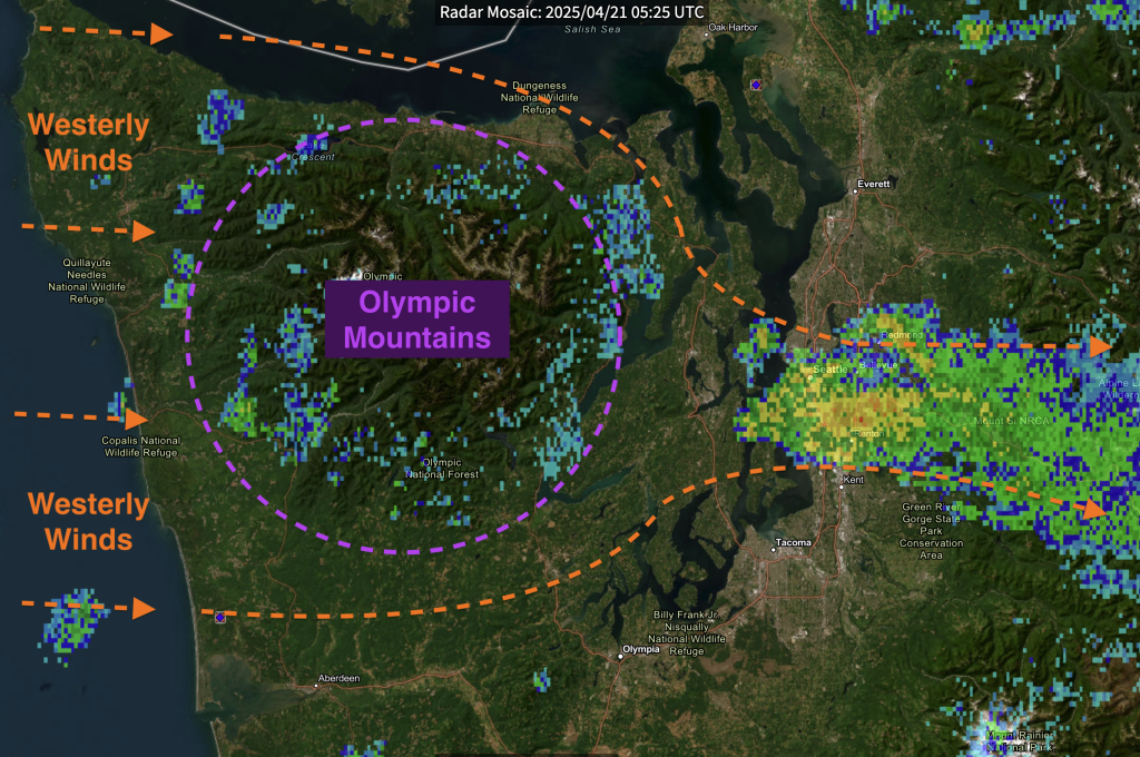 Diagram of the Puget Sound Convergence Zone (PSCZ) on the evening of April 20th. Radar imagery underlay is for 10:25 pm PST on April 20th. Yellows and oranges on the radar imagery around the Seattle Metro depict heavier rainfall while blues and greens depict lighter rainfall. Radar Data Source: NCEI Radar Viewer.