By Jacob Genuise
Spring melt began in earnest this month. Snowpack has fallen further behind our typical 1991-2020 totals as of May 1, 2025, largely as a result of dry conditions, warmer than normal temperatures, and earlier than usual melt. Snow water equivalent (SWE) fell furthest behind in the Central Columbia watershed, which as of May 1st has only 49% of median SWE.
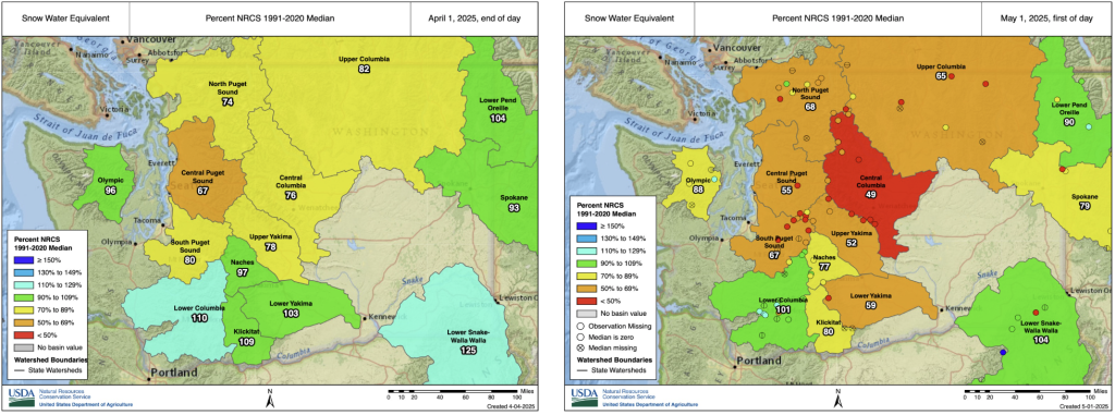 Snow Water Equivalent (SWE) percent of 1991-2020 median as of April 1, 2025 (left) and May 1, 2025 (right). Source: NRCS Interactive Map.
Other major watersheds in the Cascades, including the Upper and Lower Yakima show between 52% and 68% of median SWE as of May 1st. The Lower Columbia, Lower Pend Oreille, and Lower Snake-Walla Walla watersheds are now running near-normal, although the percentages of median have all declined since April 1st at which point these watersheds had above normal snowpack. Altogether, this indicates that many watersheds are melting out a bit sooner than normal this year. Along with below normal snowpack this year, the early melt-out reinforces concerns for water resources later in the warm season.
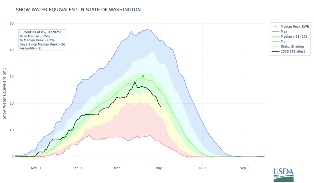 Snow water equivalent for all Washington State SNOTEL sites. Beneficial snows greatly increased SWE in the middle of the month, then warm temperatures led to considerable melting from March 25-27, 2025. Source: NRCS basin plots.
This earlier-than-normal snowmelt has also led to elevated streamflow across the state. The map below shows streamflow as a percent of normal for April. Dark blue and teal colors in north central Washington indicate above normal streamflow. The three main factors that influence natural streamflow are melting snowpack, rainfall, and groundwater; the last of which is itself largely determined by snowmelt and rainfall. Given that we have seen below normal precipitation this month, a likely explanation for higher flows is the earlier-than-normal snowmelt, particularly along the Cascade crest and north central Washington. The near-normal April streamflow in western Washington (shaded in green below) is slightly unexpected given the lack of April precipitation, but a time series examination shows that the 28-day average is representing high flows early in the month from the wetter than normal March that have been steadily dropping over the course of our dry April. A few basins in western Washington already show below normal April streamflow (shaded in orange), and if May precipitation is below normal, we expect more of the rain-dominated basins in western Washington to continue this trend toward below normal streamflow as well.
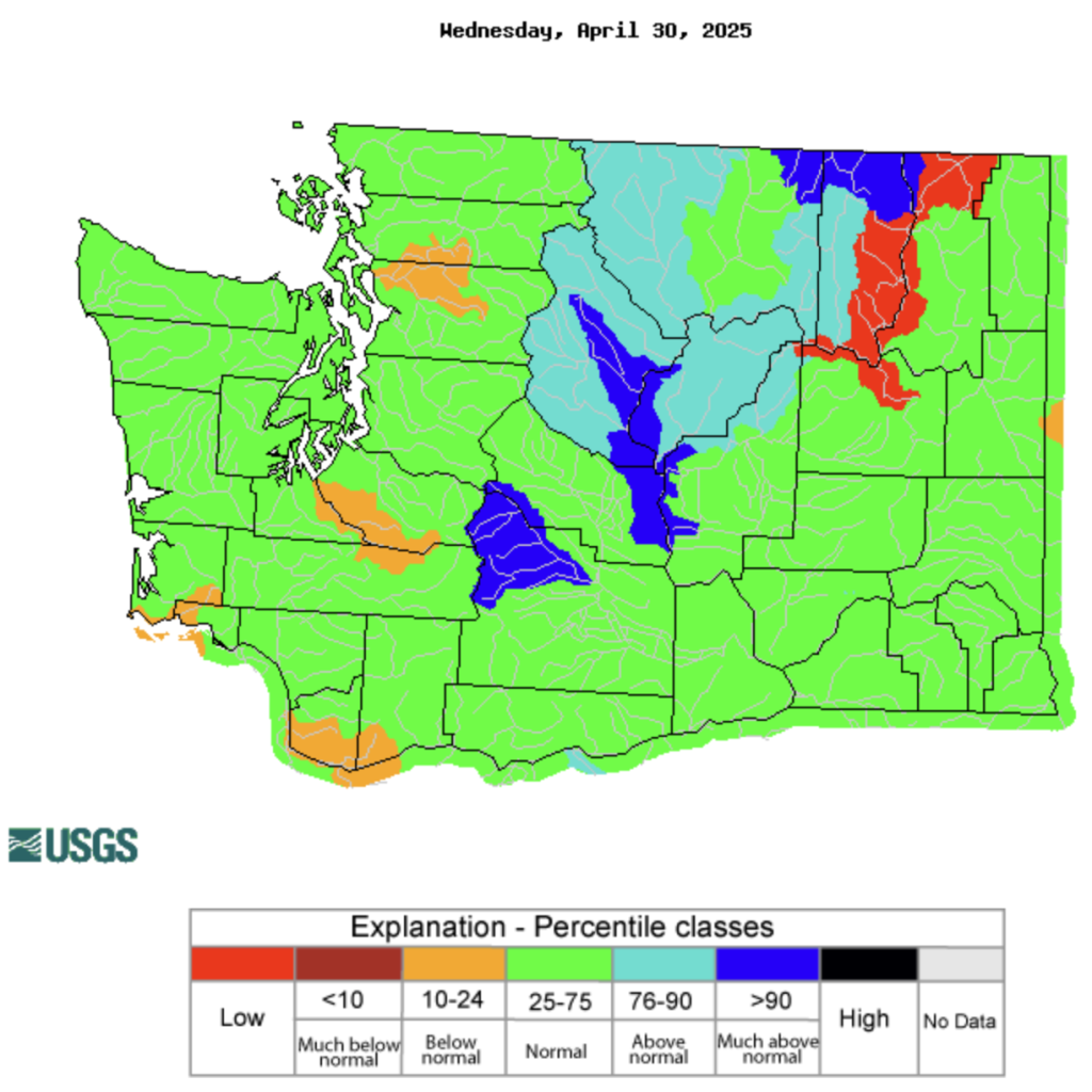 Streamflow as percent of normal, averaged by hydrologic unit for the 28-day period ending on April 30 2025. Source: USGS.
According to the U.S. Drought Monitor, Moderate Drought (D1) conditions continue in much of the Cascade Mountains and western Cascade Foothills. Abnormally dry conditions also persist throughout the Puget Sound region and have also expanded into far southwestern Washington as well as into small portions of far eastern Washington due to dry and warm conditions.
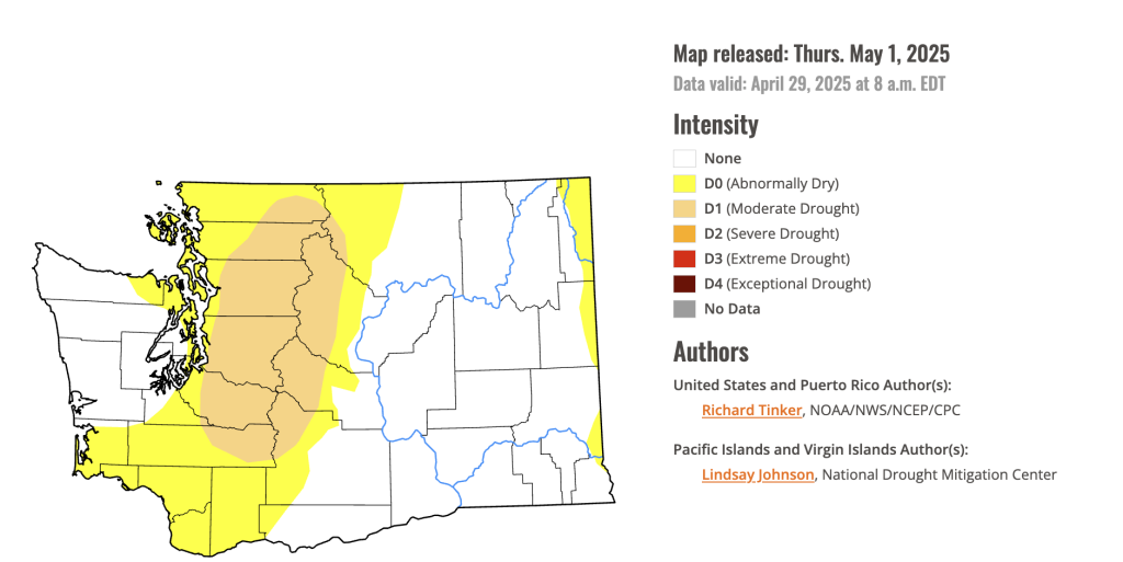 Drought conditions in Washington State as of April 29th, 2025. Source: U.S. Drought Monitor.
On April 8, the Washington Department of Ecology, with the Governor’s approval, issued an emergency drought declaration for the Upper Yakima, Lower Yakima, and Naches watersheds. At the same time, a drought advisory was issued for parts of Whatcom, Skagit, Snohomish, King, Pierce, Okanogan, and Chelan counties.