By Jacob Genuise
May was another dry month for nearly all portions of the state and ranked as the 26th driest May statewide since 1895. On the heels of dry and warm conditions in April, concerns continue to grow for worsening drought conditions as we head into summer 2025. Our April-May 2025 period now ranks as the 13th driest such period on record since 1895.
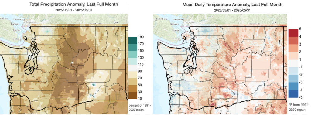 May precipitation as a percent of 1991-2020 normal (left) and May Average Temperature anomaly compared to 1991-2020 mean (right).
Similar to April, the east slopes of the Cascades from Omak south through Yakima saw the lowest precipitation totals relative to normal in the state with many spots seeing less than 30% of normal precipitation. Omak received only 38% of normal precipitation and Wenatchee received only 16% of normal. Elsewhere in eastern Washington, precipitation was around 40-70% of normal including 61% of normal in Spokane and 47% of normal in Ephrata. A few very isolated spots near the Tri-Cities received near or just above normal precipitation. Across western Washington, precipitation was around 40-90% of normal for the month with the largest deficits across the southern Puget Sound (42% of normal precipitation at Olympia and the 18th driest May on record) and south toward Vancouver, WA (55% of normal precipitation). SeaTac Airport also recorded below normal precipitation with only 44% of normal and ranking as the 12th driest May on record.
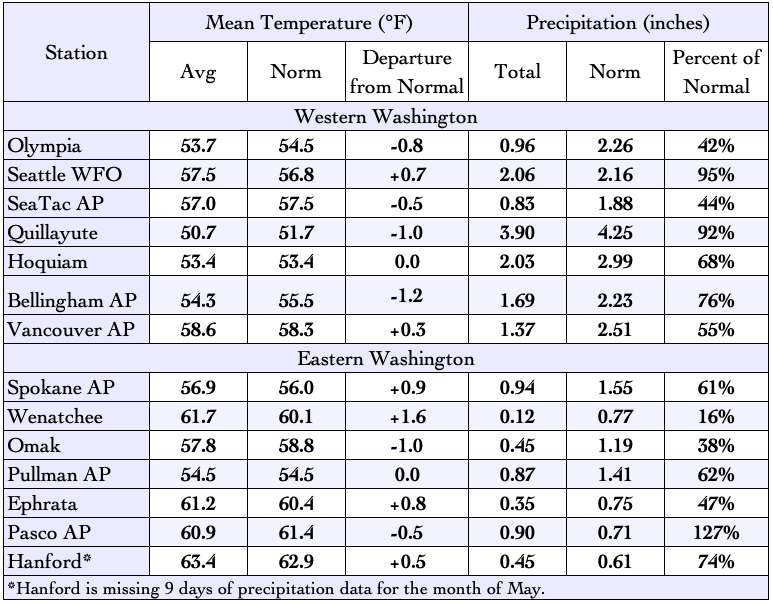 May 2025 climate summaries for locations around Washington. Anomalies are relative to a climate normal baseline of 1991-2020.
Daily averaged temperatures for May were near normal with a slight warm anomaly of 0.3°F statewide compared to 1991-2020 normal period. May 2025 ranks as the 38th warmest May in Washington since 1895. The largest temperature anomalies occurred on the eastern slopes of the Cascades where temperatures ran 2-4°F above normal. Across eastern Washington, temperatures ran within 1°F of normal. Temperatures were slightly above normal at Spokane (+0.9°F), and Ephrata (+0.8°F). A few stations in low-lying valleys such as Omak (-1.0°F) and Pasco (-0.5°F) saw slightly below normal temperature anomalies. Across western Washington, anomalies were also generally near normal with some stations such as Bellingham (-1.2°F) and Olympia (-0.8°F) recording slightly below normal temperatures while others such as Seattle WFO (+0.7°F) and Vancouver AP (+0.3°F) recorded slightly above normal temperatures.
It is interesting to note that due to extended stretches of fair weather and clear nighttime skies during May, nighttime lows were consistently below normal across portions of the state that tend to cool more efficiently on clear nights. These areas include lowland areas around Puget Sound, the Chehalis Basin, low-lying portions of the Columbia and Snake River basins as well as mountain valleys where cool air tends to pool. In comparison, daytime highs showed more consistent and even warm anomalies statewide. This unevenness in nighttime cooling across the state was a major factor in the localized areas of cool mean temperature anomalies relative during May.
 May 2025 anomalies in minimum (overnight) temperatures denoting uneven nighttime cooling.