By Jacob Genuise
Key Messages:
- March 11-18 brought heavy lowland rain, windstorms, and mountain snows to western Washington.
- Warm conditions led to early season snowmelt which cut into snowpack gains earlier in the month.
- Numerous daily precipitation records were set across western Washington and the eastern slopes of the Cascades.
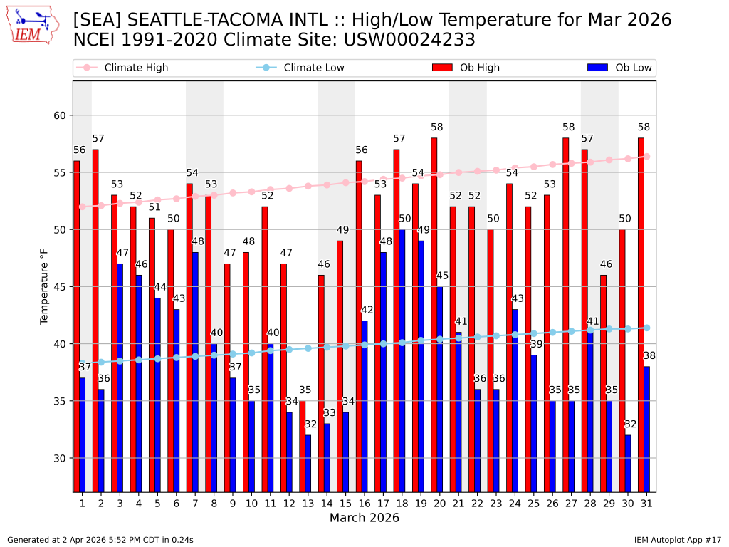 March 2026 daily high (red bars) and low (blue bars) temperatures as well as normal high and low (pink and light blue lines, respectively) for SeaTac Airport. Gray shading denotes weekends. Normals are based on the period 1991-2020.
 March 2026 daily high (red bars) and low (blue bars) temperatures as well as normal high and low (pink and light blue lines, respectively) for Spokane. Gray shading denotes weekends. Normals are based on the period 1991-2020.
March began with a warm precipitation event that brought very little mountain snowfall across the state. A cooler wet period began on March 11 and lasted through the 18th bringing widespread lowland rainfall and mountain snow. CoCoRaHS observations on the map below show the heaviest lowland precipitation occurred in the south Sound and on south to Portland. Strong winds on the 11th downed trees, left 35,000 customers without power in western Washington, and caused one wind-related death. Rainfall on the 11th also broke numerous daily precipitation records including at SeaTac (1.15”, previously 1.01” in 2002), Olympia (2.17”, previously 1.44” in 2002), and 1.55” near Leavenworth (previously 0.77” in 2002). March 13th also broke numerous records including at Rainier Paradise SNOTEL station where 4.20” of precipitation fell, breaking the previous daily record of 1.60” in 2017. This total also tied with March 5, 2014 as that station’s wettest March day on record.
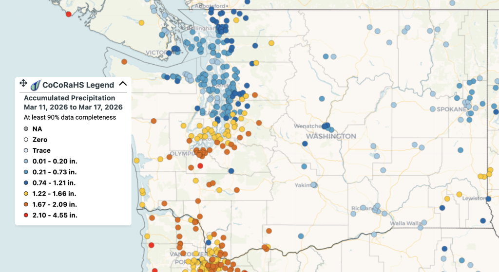 CoCoRaHS precipitation observations from March 11-17.
Colder air arrived on the 13th, supporting widespread light lowland snow across western Washington including 3.0” at SeaTac. Heavy cloud cover kept temperatures cool throughout the day, making March 13 the coolest day of the 2025-2026 fall and winter season in terms of average daily temperature. This is both a testament to how cool this early spring day was, but also to how remarkably warm the rest of the winter has been. On the eastern side of the state, Spokane recorded 8.2” of snowfall on the 13th making this date their snowiest day this winter.
As a high pressure system strengthened in the southwestern U.S. and brought record-breaking warmth to the interior west, it also continued to steer moisture off the Pacific and toward Washington state. This atmospheric river event continued from the 14-18th bringing more rainfall on top of already-impressive precipitation totals from earlier in the month. Minor to moderate flooding occurred on regional rivers as a result of this extended period of rainfall, and additional snowmelt occurred due to abnormally warm conditions. Bellingham broke two daily precipitation records, including 0.99” of rainfall on the 16th (previous record 0.69” in 1950) and 0.84” on the 18th (previous record 0.51” in 1973). As a result of this long-duration heavy rain event, 3 landslides occurred just south of Bellingham along I-5 and SR-11 (Chuckanut Drive) on March 19 and 20.
Additional rainfall continued through the 21, mostly in the northern Cascades and Olympics, then colder air worked back into the region late in the month bringing a late-March freeze to SeaTac and nightly freezes across eastern Washington.