By Matt Rogers, Research Scientist at the UW Climate Impacts Group
Snowpack is an important source of water for Washington. Reservoirs also help store water from snowmelt, releasing it as needed throughout the dry season. This year’s drought has renewed conversations about the amount of water in our snowpack and reservoirs, and just how much we can rely on each for meeting water demand in the future. Let’s take a closer look at our current and future snowpack and how these relate to our current reservoir storage, focusing on Puget Sound.
For Washington state as a whole, we estimate the average volume of April 1st snowpack to be between 16 and 18 million acre-feet, on average for 1986-2011, or between 8 and 9 million Olympic-sized swimming pools of water. These estimates are based on my analysis of three different snow reanalysis products (WUS-SR, UofA 4km, and UofA 800m). “Reanalyses” combine observations and models to make a best estimate that accounts for uncertainties in both. The figure below shows April 1st snowpack volume for 1986-2011 by water resource inventory area (WRIA), based on the WUS-SR dataset. We chose to focus on this dataset because a recent study suggests it outperforms the other two datasets in basin-scale snowpack estimates. Not surprisingly, the map shows that April 1st snowpack is found in the mountains, and is largest at the highest elevations in Washington State
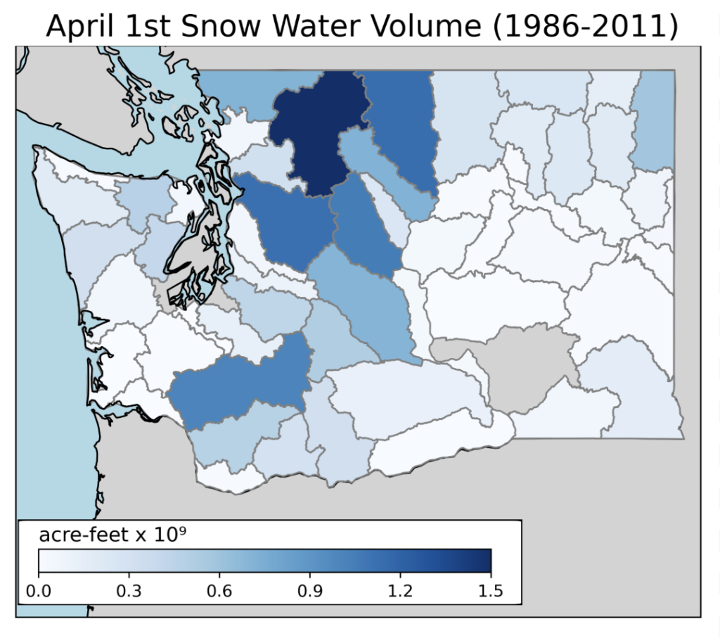 Average estimated volume of water stored in April 1st snowpack between 1986-2011 by water resource inventory area (WRIA). The data source for this map is the Western US Snow Reanalysis dataset (WUS-SR).
We’ve already estimated our snowpack volume for Washington State, but what about reservoir volume? If we want a complete view of Washington’s water supply during the summer we can’t neglect the role of reservoirs. Our reservoirs rely on both precipitation and snowmelt to replenish their stores in spring, allowing them to release this water later in the dry season. Washington reservoirs do not have enough capacity to store multiple years of water without replenishing as do some other larger reservoir systems in the west, so snowmelt conditions in spring and summer each year can make a big difference for meeting annual water supply demands.
How does Puget Sound’s Snowpack compare to its Reservoir Storage?
The Washington Department of Ecology monitors more than 1,000 dams with 10 acre-feet or more of storage. In order to have a smaller number of reservoirs to investigate in more detail, we started with just the Puget Sound region. Using data provided in the 2026 Dam Inventory Report produced by the Washington State Department of Ecology, we estimate the total capacity of 15 of Puget Sound’s largest dams to be about 3.2 million acre-feet, or about 1.6 million Olympic-sized swimming pools (see the final section of this article for more information on the data we used). As expected, the maximum storage capacity of these dams is considerably less than the total water in April 1st snowpack for Puget Sound. Using the same WUS-SR dataset as above, we estimate an average April 1st snowpack of 6.9 million acre-feet, or 3.45 million Olympic-sized swimming pools, for Puget Sound. Worth noting: not all of this snowmelt is captured by reservoirs. This is because some of the snowpack is not upstream of any reservoir, and some is evaporated into the air before it can runoff into reservoirs.
Maximum reservoir storage is probably an overestimate of how much water a given reservoir can release, since reservoirs need to maintain a minimum water level to meet other management requirements such as hydropower, habitat, and recreation. We consulted with the groups operating 15 major Puget Sound dams to estimate the “usable storage” for each reservoir. Based on the information we received, we estimate usable storage within these reservoirs to be about 1.8 million acre-feet, or roughly 900,000 Olympic-sized swimming pools. This is a little more than half of the maximum storage listed above from the 2026 Dam Inventory Report (~3.2 million acre-feet). In other words, using the maximum storage estimates could greatly overestimate the available storage from Puget Sound reservoirs and their potential role as a source of water in summer.
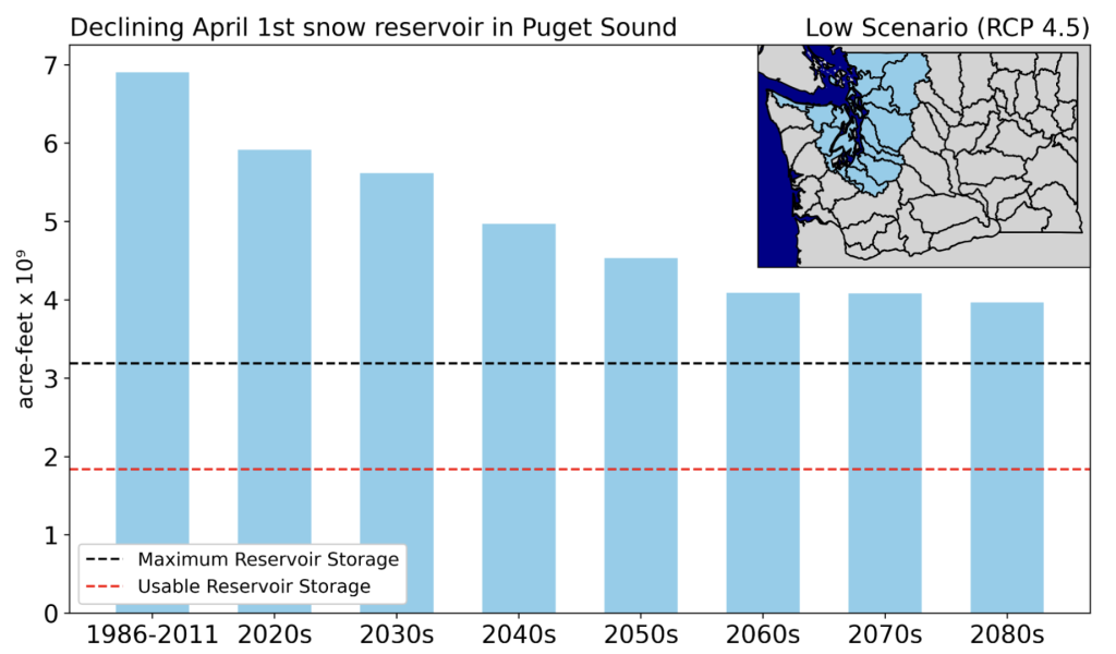 Future declines in April 1st snowpack in the Puget Sound region under a low greenhouse gas scenario compared to the maximum and usable storage for reservoirs. Climate projection data is from the RMJOC-II hydrologic model simulations.
April 1st snowpack is projected to decline in the future as our climate continues to warm. The figure above shows that, for the 1986-2011 period, models estimate roughly 3.5 times as much water in our April 1st snowpack than the current usable storage by reservoirs in the Puget Sound region. By the 2080s, under a low greenhouse gas scenario (RCP 4.5), April 1st snowpack is still projected to be more than the usable storage, but only about double instead of 3.5 times our current usable storage. This reinforces the importance of snowpack, even as it diminishes in the future. The projections also show that we won’t be able to rely on snowpack as much in the future. Given that we already experience droughts in many years, we can continue to expect water shortages in the future when our spring snowpack is projected to average about 2 million acre-feet lower than today. This makes it especially important to continue current efforts to mitigate the effects of drought in Washington State. For example, multi-agency, tribal, and non-profit collaboration in the Dungeness Basin has reduced adverse drought impacts to salmon during the last several droughts through modifying channels on the Dungeness, dry year leasing, timed agriculture irrigation shut offs, and water conservation messaging. More detail on this and other actions can be found in the PNW Water Year 2024 Impacts Assessment.
Data Used: In Detail
The three snowpack reanalysis datasets we explored were the Western US Snowpack Reanalysis (WUS-SR) dataset, the University of Arizona 4km product (UofA4km), and the University of Arizona 800m product (UofA800m). We displayed the WUS-SR as a recent study suggests this dataset performs the best among similar products at basin-scale estimates of snowpack.
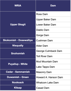
The 15 dams we assessed for the Puget Sound region were:
We calculated the future estimates of snowpack volume by applying model median percent changes in basin snowpack volume from the RMJOC-II hydrologic simulations to the historical basin estimates of snowpack volume from the WUS-SR dataset.