By Jacob Genuise
Key Messages:
- Streamflows in mountain basins continue to run below to extremely below normal due to poor snowpack and dry summer conditions.
- Water supply forecasts have remained relatively unchanged, with continued expectations of well below normal summer water supply for all major rivers besides the Columbia.
- Drought expanded slightly in the northern Olympic Peninsula, Okanogan County, and across far eastern Washington in July.
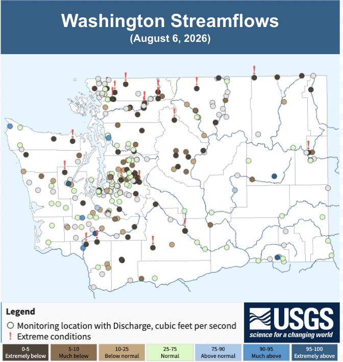 USGS streamflows map as of August 6, 2026.
Streamflows continue to run below normal, much below normal, or extremely below normal across most mountain basins. As of August 6th, 2026, 20 gauges across the state were reporting record low daily streamflow. These gauges are shown with a red exclamation mark on the map of streamflow gauges across Washington.
Drier than normal conditions this summer in many areas have driven continued low streamflows. Hydrographs of the Dungeness Right (left) and the Wenatchee River (right) show this persistent low streamflow characteristic of many mountainous basins this year. Streamflow in the Dungeness has approached or exceeded record low flows this past month, while streamflow in the Wenatchee River has been near the 5-10th percentile this summer.
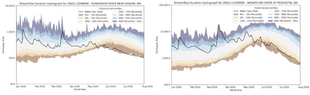 Streamflow hydrograph from January 1- August 5. 2026 for the Dungeness River in the north Olympic Peninsula (left), the Wenatchee River just west of Wenatchee (right).
In the Yakima Basin, total basin reservoir storage continues to run below normal, and this year’s reservoir drawdown has slightly outpaced average drawdown rates. While reservoir levels are currently healthier than they were at this time last year, storage is running below normal. The latest U.S. Bureau of Reclamation water supply forecast, released on August 6th, indicates that Junior water rights holders are expected to receive 58% of their entitlements, a slight increase from the previous monthly forecast. Junior water rights represent over half of the water rights in the basin.
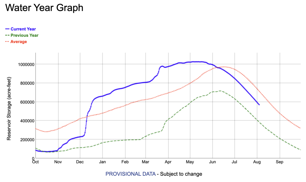 Yakima River Basin total reservoir storage through August 5, 2026. Data from the U.S. Bureau of Recreation. The solid blue line shows current year storage. The dashed green line shows last year’s storage. The dotted red line shows average reservoir storage.
The U.S. Drought Monitor shows worsening drought conditions across the state. D1, “Moderate Drought,” was introduced across the northern Olympic Peninsula, and D2, “Severe Drought,” expanded in Okanogan County and across far eastern and southeastern Washington. There was some slight improvement in drought conditions in Grays Harbor County due to beneficial rains. The drought monitor change map below illustrates the change in drought classification over the past 5 weeks.
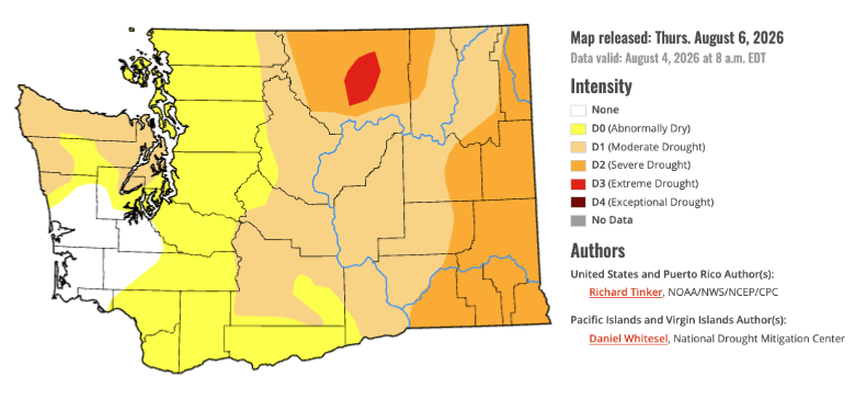 U.S. Drought Monitor for Washington. Data valid on August 4, 2026.
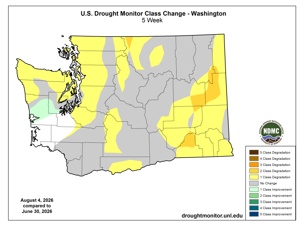 U.S. Drought Monitor class change from June 30 to August 4, 2026.