By Sanjita Bhavirisetty and Lav Khot at the Washington State University AgWeatherNet
Washington’s climate is not uniform, and it is becoming increasingly extreme, particularly during agricultural crop production seasons. Declining mountain snowpack, spring frost, extreme summer heat, and wildfires are becoming the norm. All this is wreaking havoc on Washington’s high-value crop production systems annually. High-value fruit crop growers can lose much of their crop to a single unmanaged extreme frost or heat stress event. Growers also need a better understanding of insects and pest pressure and population dynamic changes as a function of weather for timely crop protection. Equally important is quantifying weather-driven crop water demand to guide water allocation decisions during periods of competing summer water use. This need is amplified by the declining winter snowpack, which is increasing the uncertainty of summer water supplies. The dairy and beef cattle industries struggle to mitigate risks related to extreme summer heat and air quality, which also shape the quality of work life for one of the largest agricultural labor workforces in the nation.
This is where knowing regional- and location-specific weather as well as forecasts becomes essential, a role Washington State University’s AgWeatherNet (AWN) program has been fulfilling since 1989.
Click to view the AWN Web Portal
Weather sensing backbone for WA State
Established by grower demand, AgWeatherNet’s foundation is a network of over 380 automated public-private weather stations spread across Washington state reporting air temperature, air quality, humidity, wind, solar radiation, and soil attributes every five minutes. Adding publicly available USDA AgriMet stations, the combined weather monitoring spans to over 550 stations across the Pacific Northwest. This density matters as Washington state is made up of ten climatic zones and various microclimates in key ag-production areas. For example, spring frost risk can vary greatly within a few miles in the Yakima, Wenatchee, Okanagan or Hood river valleys, due to elevation and cold-air drainage.
AWN data goes through rigorous quality checks before being used to forecast the weather and drive the commodity specific decision support tools. The web portal and mobile application enable this along with voice, text, email and in-app push notifications. This is an effort to help our stakeholders respond proactively to extreme weather events. The “AgWeatherNet” app (available on iOS and Android) simplifies the data accessibility significantly and complements the web portal. It is the first of its kind standalone customizable app built to have key ag-weather decision tools and push notifications at the fingertip. Both platforms are fully accessible and bilingual, in English and Spanish, serving the makeup of Washington’s agricultural workforce and rural communities. The app is designed to serve casual users and agricultural professionals alike. The web portal has over 28,000 registered users accessing data and decision support tools over 14.8 M times annually. The AgWeatherNet app is new, launched in summer of 2026, and already has 3300 downloads.
Click to Learn more and Download the iOS or Android App
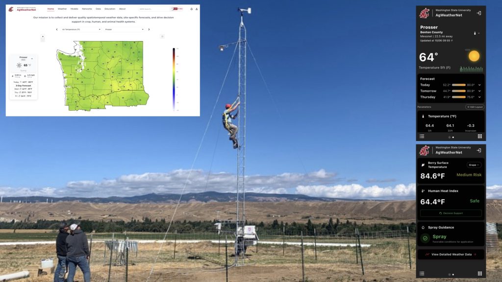 Typical AgWeatherNet station and inserts of web and mobile app based grower decision support tools
From data to decisions
What distinguishes AgWeatherNet from a typical weather app is the real observed data, not gridded forecast, and layer of decision-support tools driven by this quality data feed to application-specific models, translating data into management action for crop, human, and animal health systems. AWN also delivers popular weekly weather outlooks and daily Spring Frost Forecasts issued for the Central Basin and the Yakima, Wenatchee, and Okanogan valleys.
Beyond frost, AWN’s decision support suite includes crop-specific cold-hardiness and chill accumulation models tracking dormant-plant survival; growing-degree-day summaries anticipating crop growth stage and pest emergence models (offered through WSU DAS); evapotranspiration estimates for water managers; a “When-to-Spray” advisory for improving targeted sprays with reduced pesticide drift, among other resources.
Newer tools extend the network toward human and animal welfare: a cattle comfort index, an air quality index feed for wildfire smoke exposure, and heat-awareness alerts for outdoor workers and the public. A decision-support model only helps if someone sees it in time. AWN has built configurable alerts directly into the platform: users set thresholds for frost, extreme heat, wind, and other events, and choose email, SMS, in-app push, or automated voice call, in English or Spanish.
A phone call, not an unread inbox, is what wakes a grower at 3 a.m., just in time to start a wind machine to mitigate frost risk in fruit crops. The same flexibility lets public-sector users route heat or air-quality alerts to on-call staff.
From regional network to farm-level precision management: AWN Smart Farms
AgWeatherNet’s core network delivers regional and site-specific data, including that of a grower deployed private weather station. A newly launched AWN Smart Farms platform expands the scope to drive sensing driven decision support down to an individual block or field.As of now, AWN Smart Farms are generating site-specific recommendations for irrigation, frost, and heat mitigation, with pilot irrigation automation control to protect fruit crops from heat. In two-year commercial apple orchard block trials, automated irrigation scheduled through the platform saw 20-52% water savings over conventional practice, and fruit temperature sensor-guided evaporative-cooling to mitigate heat stress used 46-51% less water – both without hampering fruit quality or yield.
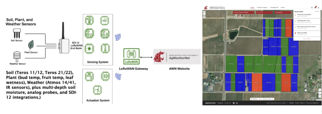 Overview of AWN Smart Farms Platform sensing, data collection, and decision support layers.
Beyond agriculture
For Climate Matters readers, the relevance goes past agriculture. AgWeatherNet is, in effect, a publicly available climate monitoring infrastructure that state and federal agencies can use. This dense quality climatological data not only improves regionwide weather forecasts through NOAA but also enables tracking seasonal analogs of drought, heat, and frost risks as they evolve. Climatology can also help guide residential land use planning and resources in years to come. As Washington sees hotter and smokier summers, declining mountain snowpacks, and changing extremes , that hyper-local picture becomes more valuable to agencies responsible for public health, water allocation, emergency response or future resource use planning.
In summary, Washington’s weather has never been one-size-fits-all, and as the climate shifts, granularity of observation matters more than ever. AgWeatherNet’s growing network of public-private stations, farm-specific data, and the data-driven decision-support tools will thus need to continue helping growers, agencies, and communities across the state in years to come.