By Jacob Genuise
Key Messages:
- Temperatures were 1-4°F above normal across much of the state, marking the 8th consecutive month with above normal statewide temperatures.
- The Olympics, Puget Sound, southern I-5 corridor and the Cascades were the warmest relative to normal. Low overnight temperatures in southeastern WA kept monthly temperatures slightly below normal in and around Pullman.
- Averaged statewide, June was drier than normal with less than 50% of normal precipitation across the eastern Cascades and virtually all of eastern Washington. Less than 30% of normal precipitation fell in the Yakima Valley and the lower Columbia River basin.
- Much of western Washington received near or just below normal precipitation. Far northeastern Washington in and around the town of Colville received above normal precipitation.
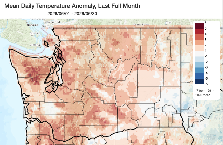 June 2026 mean temperatures compared to 1991-2020 normals.
Temperature: Temperatures were once again above normal across most of the state, although they weren’t quite as anomalous as in May. Across western Washington, temperatures were generally 2-4°F above normal including +3.1°F in Seattle, +0.9°F in Vancouver, +2.0°F in Olympia, and +1.7°F in Hoquiam toward the coast. Across eastern Washington, temperatures were generally 1-3°F above normal with the highest temperatures relative to normal occurring across the eastern slopes of the Cascades. Temperatures were +2.5°F above normal in Wenatchee, +1.8°F above normal in Ephrata, and +0.9°F above normal in Pasco. Minimum temperatures in southeastern WA were below normal due in part to clear overnight skies throughout much of the month. Pullman recorded slightly below normal average temperature for the month as a result.
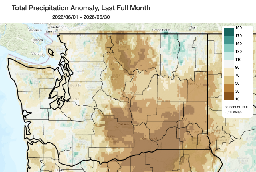 June 2026 precipitation as a percent of 1991-2020 normals.
Precipitation: June was overall much drier than normal east of the Cascades crest, and near or just below normal across western Washington. Conditions were particularly dry across the eastern slopes of the Cascades, the Yakima Valley, and across the lower Columbia Plateau near Walla Walla and the Tri Cities, key agricultural belts for the state. Most of these areas saw less than 50% of normal rainfall, while Yakima and the Tri Cities saw less than 30% of normal rainfall. The combination of below-normal precipitation and above-normal temperatures likely increased evaporation and accelerated water loss from soils and vegetation.
One exception to the dryness across eastern Washington occurred in the southern end of the Selkirk Mountains in and around the town of Colville. Favorable storm tracks and some afternoon storms brought near to above normal precipitation to this area. This will help lessen fire risk over the next couple of weeks in this small area of the state, but the rest of eastern Washington has experienced continued drying through June.
As for western Washington, despite a couple of wetter and cooler periods toward the beginning and end of the month, monthly total precipitation came in near or slightly below normal in most spots. Most areas saw 80-110% of normal precipitation including 96% of normal at the Seattle WFO, 98% of normal in Hoquiam, and 109% of normal in Bellingham. A few lucky spots received above normal precipitation including 145% of normal in Olympia.
More information on the day-to-day variations in weather for the past month and the warm/cold and wet/dry streaks can be found on the revamped National Weather Service climatology pages; you can access locations within the Seattle, Spokane, Portland, and Pendleton forecast areas.
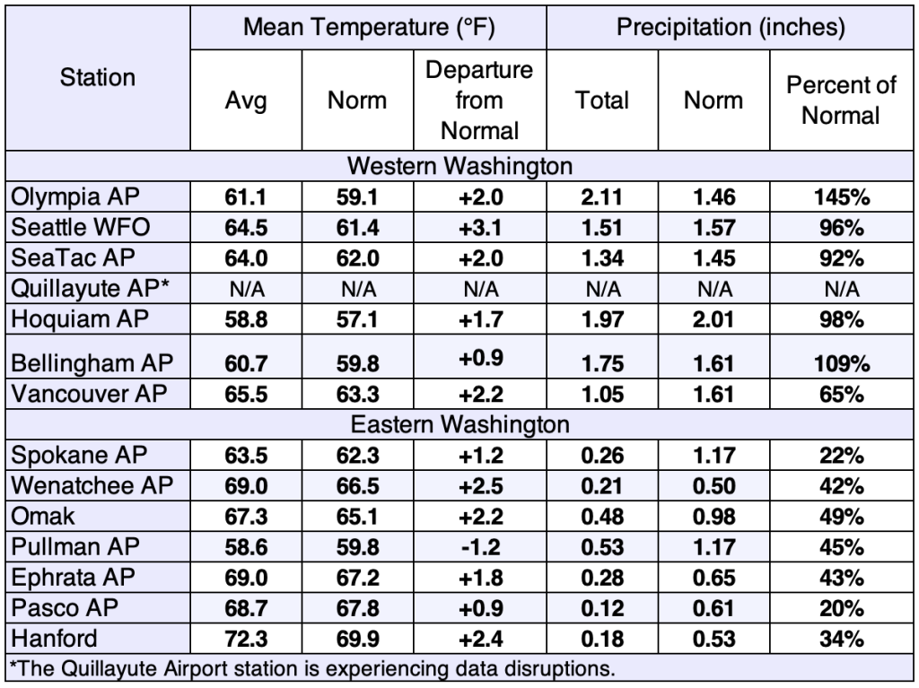 June 2026 climate summaries for select locations around Washington. Anomalies are relative to a climate normal baseline of 1991-2020.