By Jacob Genuise
 Observed daily high and low temperatures (dark bars) as well as records and normals (background shading) for SeaTac Airport. Data unavailable beginning May 27.
May 2025 featured near normal temperatures statewide, aside from some notable warm spells, and below normal rainfall when averaged statewide. The majority of the month’s rainfall occurred during a more active period of weather from May 11-20. The CoCoRaHS network precipitation map shows total rainfall for this period across the state with the highest station totals (2”+) in the foothills of the Cascades and Olympics. 1.00-2.00” of rain fell on the eastern side of Puget Sound and near Spokane. Most of the leeward (eastern) side of the Cascades received very little precipitation during this more active period and for the month as a whole (see the May 2025 Climate Summary for more details).
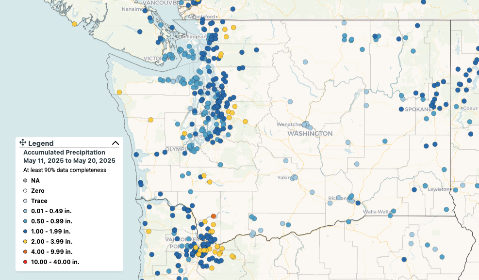 Statewide rainfall totals from May 11-20, 2025 as recorded by CoCoRaHS network stations.
Temperatures were slightly cooler than normal during this rainy period, but not cool enough to offset notable warm periods toward the beginning and end of the month. On May 1 temperatures across western Washington climbed into the mid to upper 70s in central Puget Sound and into the lower 80s across the Chehalis Basin. On May 2, cooler onshore flow returned to western Washington and the warmest temperatures shifted to the eastern half of the state. Temperatures in eastern Washington rose into the mid to upper 80s in the Columbia Basin, and Walla Walla Regional Airport set a daily record of 86°F beating the previous daily record of 82°F set on May 2, 2016. Warmth returned briefly across the state on the 6th-8th as onshore flow waned, then temperatures moderated to near or just below normal through the middle portion of the month.
 Maximum temperature on May 28th, 2025. Data from PRISM. Map created using SC ACIS.
A ridge of high pressure then began to build again across the state on May 24. Temperatures warmed over the next few days, and peaked for much of the state on May 28. Temperatures soared into the lower to mid-80s across Puget Sound, and easterly downsloping winds allowed for locally higher temperatures along eastern foothills of the Cascades with numerous readings near 90°F. Meanwhile, in eastern Washington, temperatures rose into the 90s including 91°F in Yakima and 93°F at Spokane Felts Field Airport on May 28.
In the evening and overnight hours of May 29, an onshore push of cooler air brought a brief reprieve from warm temperatures for western Washington. Heat continued to build again in eastern Washington through the end of the month. The Pasco Airport briefly reached 95°F on the afternoon of May 31 and the nearby Richland Airport recorded a daily high temperature of 97°F. This represents the highest reliable temperature recording in Washington State so far this year, as of May 31. In the late afternoon of the 31st, a cold front moved in from western Washington and brought strong winds to the eastern slopes of the Cascades. A station near Ellensburg, located in the wind-prone Kittitas Valley, recorded a gust to 59 mph with gusts of 45-55 mph elsewhere in the Columbia Plateau. Blowing dust was also widespread due to the recent dry conditions and strong winds, and temperatures dropped 15-20 degrees in just a couple of hours as the front passed through.