By Jacob Genuise
June 2025 was a relatively dry and warm month statewide (read the June Climate Summary for a more detailed discussion of anomalies).
The first 10 days of the month featured a gradually strengthening ridge of high pressure across the region. This caused temperatures to rise from near seasonal normals at the start of the month to around 20 degrees above normal throughout Washington by June 8-10. The daily high and low temperature graphs for SeaTac and Pasco/Tri Cities show this early season heat wave toward the left hand side of each graph. Note that these graphs are from a different source than what we usually show, so make sure to take a closer look and let us know if you prefer one over the other.
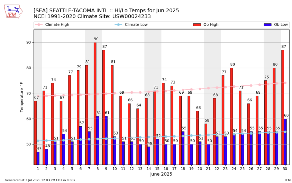 Observed daily high (red bars) and low (blue bars) temperatures as well as normal high and low (pink and light blue lines, respectively) for SeaTac Airport. Gray shading denotes weekends.
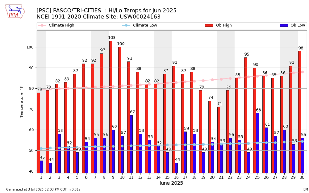 Observed daily high (red bars) and low (blue bars) temperatures as well as normal high and low (pink and light blue lines, respectively) for Pasco/Tri Cities Airport. Gray shading denotes weekends.
On June 8th the most impressive temperatures relative to normal were centered around the Cascades and across western Washington. Daily high temperature records were set or tied at Vancouver Pearson Airport (96°F, previously 91°F in 2015), SeaTac Airport (90°F, previously 87°F in 2015), White Pass SNOTEL (83°F at an elevation of 4440’, previously 82°F in 2015), and Easy Pass SNOTEL (73°F, situated a perfect mile above sea level at an elevation of 5280’, tied with 2015), among many others.
On June 9th, the hottest temperatures shifted toward eastern Washington, once again setting a number of daily high temperature records. A selection of these daily records included 103°F in Pasco (previously 98°F in 2015), 103°F in Yakima (previously 101°F in 2015), 102°F in Ellensburg (previously 94°F in 2015), and 94°F in Spokane (previously 93°F in 2015). Do you notice a theme in the year of the previous daily records for June 8th and June 9th? This year’s heat wave occurred on the 10 year anniversary of a similar early season heat wave in June 2015. There is growing evidence that heat waves are occurring earlier in the warm season and extend later into early fall.
As the ridge of high pressure moved eastward, temperatures finally fell back to near or just below normal by the 10th-12th. Across eastern Washington, a string of nearly cloudless nights allowed temperatures to cool into the low to mid 40s overnight. At Pasco/Tri Cities Airport, temperatures dropped to 44 degrees overnight on the 16th into the 17th. This gave Pasco an impressive monthly temperature range of 59°F spanning from a high of 103°F on June 9 to 44°F on the morning of June 17. SeaTac had a monthly temperature range of 43°F with a monthly low of 47°F on the morning of the 2nd and a monthly high of 90°F on the afternoon of June 8.
Some light precipitation fell on June 19-22nd across mainly western and far northeastern Washington, but this did little to offset the absence of rain throughout the rest of the month. A June 2025 map of the maximum consecutive dry days, defined as days with less than 0.04” of precipitation, reveals just how long many folks had to wait between rains. Across the Columbia Basin of eastern Washington, the brown shading on the map indicates 26+ days without precipitation with many spots observing no rain at all. Across western Washington, including the western slopes of the Cascades, the longest dry stretch occurred in the first half of the month when close to 14 days passed with no rainfall (medium yellow shaded areas on the map). A few lucky spots in the Okanogans and Rockies saw some slightly more frequent showers throughout the month, seen in small areas of green shading on the map.
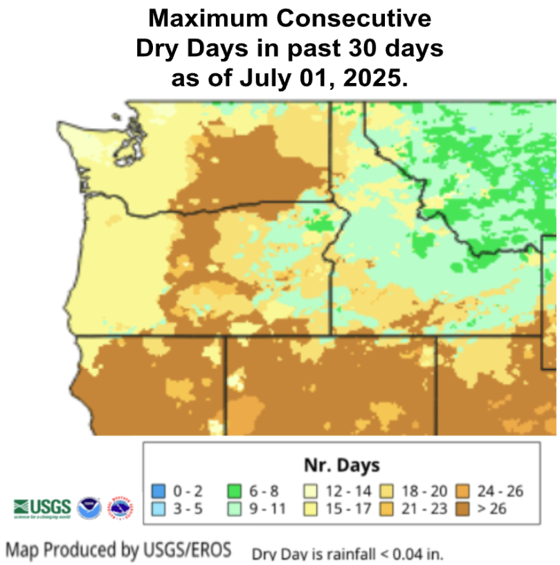 Maximum consecutive dry days in June 2025.
A brief visit from Canadian and Alaskan wildfire smoke on June 23 brought moderate reductions to air quality and noticeable visibility declines across Washington. Read more about the nearly 1,500 mile journey of this wildfire smoke as well as the small Pomas Fire burning near Entiat, WA on the Washington Smoke Blog. The Pomas Fire is burning on the footprint of the 2015 Wolverine Fire to add to the eerie similarities between June 2025 and June 2015. To end the month, sunny and largely dry weather returned across the state.
June is often a month of transition as we begin to welcome the longer stretches of sunshine that define Washington summers. Nevertheless, this June as well as the year as a whole has been particularly sunny. The National Weather Service notes that SeaTac has seen just 75 cloudy days from January 1 – June 30, 2025. This is a whopping 47 days below the 122 cloudy days we expect at SeaTac over this period.
Widening out to the state as a whole, the map below shows cloud cover anomalies for April through June 2025 as a percent of 1991-2020 normals. Cloud cover is below normal for this period statewide, with deficits approaching 14% below normal for the far southeastern and northeastern corners of the state. Across eastern Washington as a whole, cloud cover was 10-14% below normal, and across western Washington cloud cover was 2-10% below normal. This excess sunshine contributes to worsening drought conditions as it causes more moisture to evaporate from soils and plants.
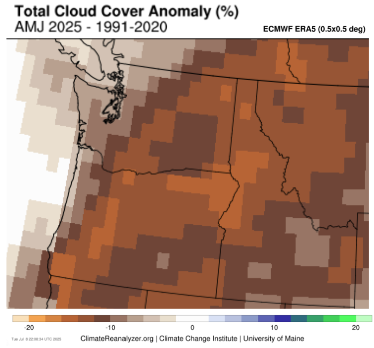 Cloud cover anomalies from April-June 2025 relative. Data from ERA Reanalysis, map made with University of Maine Climate Reanalyzer.