By Jacob Genuise
Key Messages:
- As of early May, statewide snowpack is at 33% of median. Many basins in the central and southern Cascades currently have less than 20% of their median snowpack.
- Warm and dry conditions have caused snow to melt more quickly than normal this spring.
- May 1 water supply forecasts have worsened marginally compared to last month’s forecast. Many river gauges along the upper Yakima river can now expect less than 50% of normal April-September streamflow.
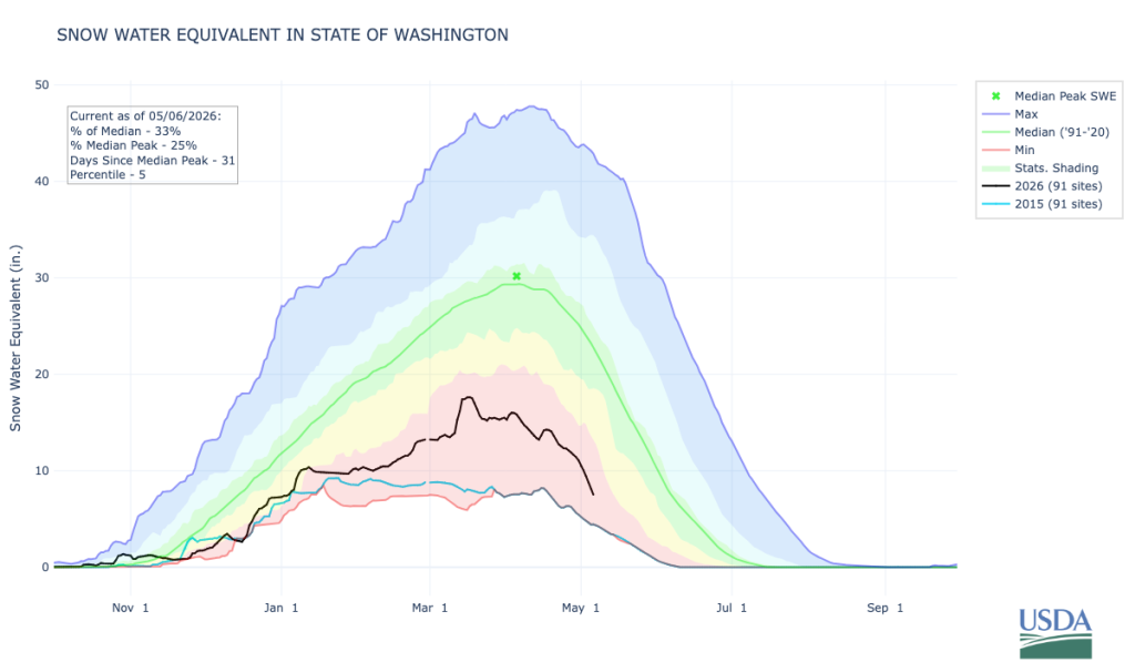 Statewide Snow Water Equivalent from October 1, 2025 through May 6, 2026. The solid green line represents the median SWE value from 1991-2020, and the black line represents SWE for the current water year. Red shading shows values below the 10th percentile (interpreted as being drier than 90% of all years), and yellow shading represents the 30-70th percentiles. The solid light blue line represents 2015, the year of WA State’s lowest snowpack on record since 1985.
In a normal year, our snowpack typically peaks in early April and then melts out gradually through April, May, and June. Unfortunately, this year’s snowpack has melted out more quickly than normal due to warmer than normal conditions during the second half of April and into early May. This season’s snowpack also peaked 2-3 weeks early with only half our normal snow water equivalent. This rapid melting of our below normal winter snowpack further increases concerns about summer water supply.
The following maps show snow water equivalent (SWE) as a percent of median for April 1 (left) and May 4 (right). Most sub-basins show even lower percent of median SWE values on May 4 than they did on April 1, suggesting that we are experiencing faster-than-normal melt. The vast majority of sub-basins across the state are now below 30% of normal SWE.
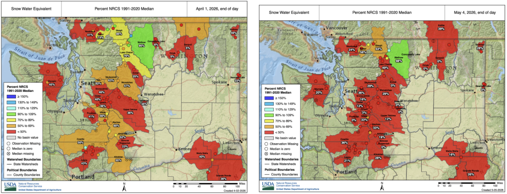 Snowpack, in terms of snow water equivalent, as of April 1, 2026 (left) and May 4 (right). Sub-basin percentages represent sub-basin-wide station averages as a percent of 1991-2020 median, while dots represent individual SNOTEL stations.
Harts Pass, the location of the highest elevation snow telemetry (SNOTEL) station in the state at 6,490 feet, is the only station still reporting near-normal snowpack at this point in the year. All other stations are reporting below or well below normal snowpack. Stations in the Okanogans, Selkirks, and Kettle Ranges of northcentral and northeastern Washington as well as low elevation stations in the Cascades and Olympics have fully melted out. For some stations, including Blewett Pass, this melt out has occurred over a month ahead of schedule.
This early snowmelt raises concerns for a longer fire season across WA and the wider region. Although fire intensity and acreage burned is often more closely linked to day-to-day wind conditions, recreation, and thunderstorm activity, low snowpack and early melt out can set the stage for an earlier start to the season as fuels tend to dry out sooner. Please be mindful and take precautions to avoid wildfire starts from campfires, lawn equipment, and towing chains. Warmer and drier than normal conditions are expected to continue over the next 1-3 months. Read more about upcoming conditions in the Early May Climate Outlook.
Water supply forecasts released by the National Weather Service Northwest River Forecast Center in early May reflect the effects of our near-record low snowpack on water supply. These forecasts represent natural, unregulated flows and therefore do not take into account reservoir operations or fluctuations in demand/consumption. This helps us see how natural sources compare to previous years prior to the influence of water management.
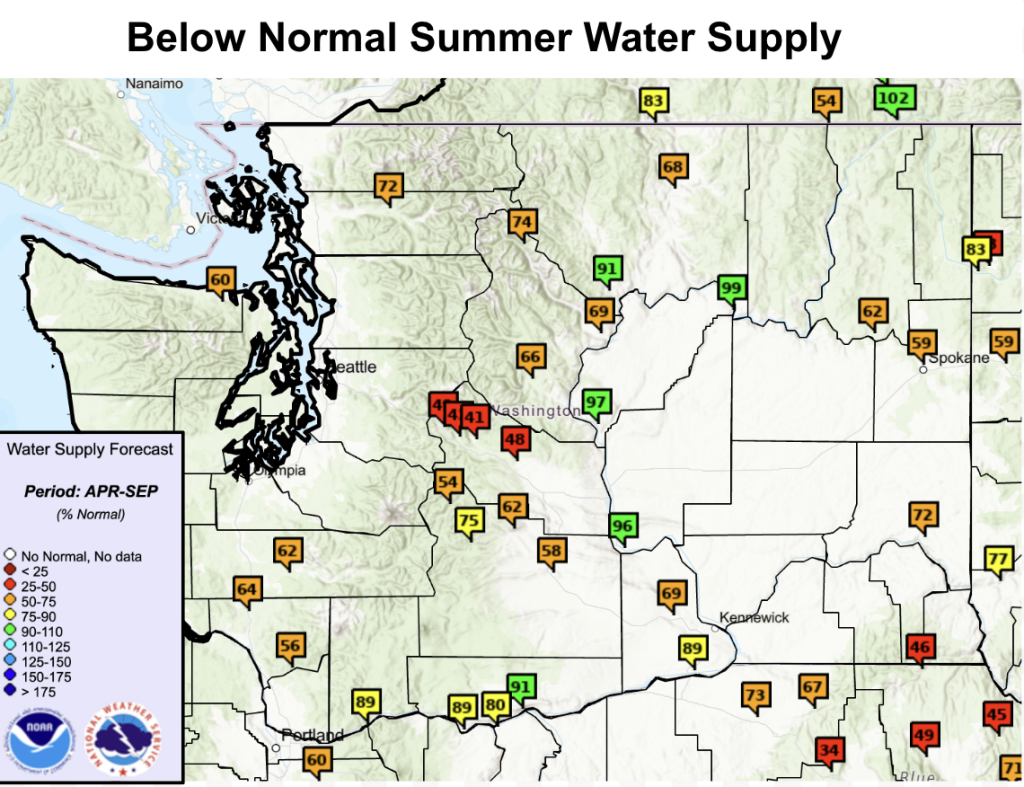 April-September NWRFC natural water supply forecast, as of May 11. Low summer water supply forecasts are caused primarily by our near record low snowpack. Spring and summer conditions could worsen or improve forecasted water supply.
Natural water supply forecasts are below normal for virtually the entire state. The exception is for gauges along the Columbia River where above normal snowpack far upstream in British Columbia will help maintain near normal water levels through the summer.
Water Supply forecasts along the Yakima river show April-September streamflow is likely to be only 40-60% of normal. Monthly streamflow forecasts for the Yakima River at Parker, for example, indicate that May and June streamflow will be especially low, at 48% and 34% of normal, respectively. For most rivers across western Washington and the eastern Cascades, these streamflow forecasts currently fall in the lowest 10th percentile, meaning water supply is expected to be lower than 90% of all years on record.Rivers across northeastern Washington as well as the Snake River in southeastern Washington are also expected to see well below normal water supply this summer.
These river forecasts have worsened slightly from the previous month’s forecast in part due to earlier than normal snowmelt. Streamflow forecasts at most gauge locations have decreased by around 5-15% of normal since the previous April 1 water supply forecasts.
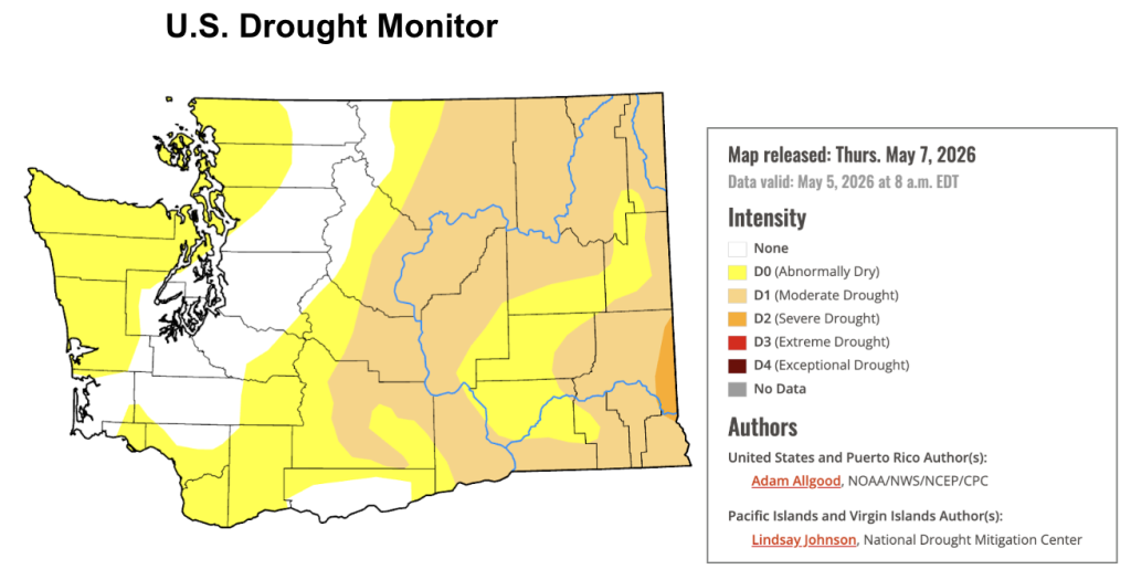 U.S. Drought Monitor for Washington. Data valid on May 5, 2026.
The U.S. Drought Monitor shows some expansion of abnormally dry conditions over the Olympic Peninsula and northern Puget Sound over the past month due to drier and warmer than normal conditions across western Washington throughout April. D1 “Moderate Drought” conditions continue along the Okanogan and Columbia Rivers in a line from Wenatchee up through the Okanogan Valley as well as in portions of northeastern and southeastern Washington. D2, “Severe Drought”, remains across the far southeastern corner of Washington near Pullman.
It is important to note that the U.S. Drought Monitor typically represents near-term drought conditions, and does not necessarily reflect future drought conditions driven by summer water supply concerns. NOAA’s seasonal drought outlook, which does incorporate a forward-looking view of the probable upcoming drought conditions, shows future drought expansion is likely, due to expectations that the remainder of spring into summer will be warm and dry in western WA. The seasonal outlook also takes our near-record low snowpack into account when assessing the sensitivity of future drought conditions to these warm and dry conditions. This outlook reflects an earlier end to the snowmelt season and faster drying of soils and wildfire fuels.
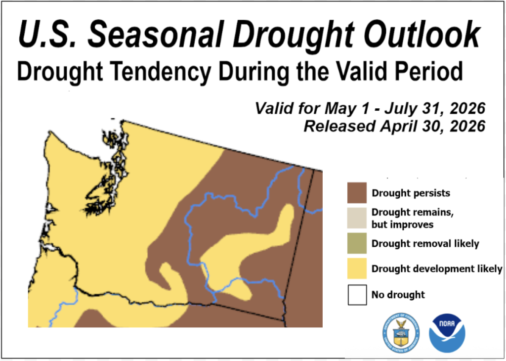 Seasonal drought outlook from May 1-July 31.