By Jacob Genuise
Key Messages:
- ENSO-neutral conditions have emerged in the Tropical Pacific, officially ending this past winter’s La Niña.
- A relatively rapid transition to El Niño conditions is likely by early summer, then El Niño conditions are likely to continue to strengthen into the fall.
- The May through July outlook includes elevated chances of both warmer than normal and drier than normal conditions. These conditions would continue to accelerate snowmelt, increase evaporation and irrigation needs, and place additional drought pressure on the region.
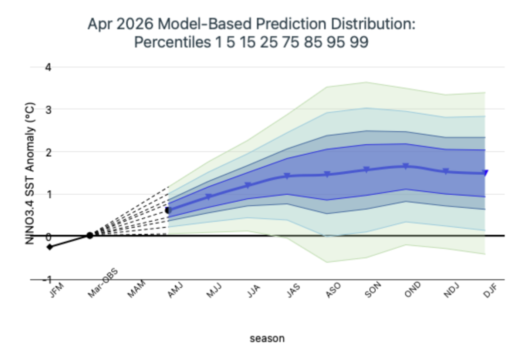 ENSO probability distribution through winter 2026-2027. Sea surface temperature anomaly values above +0.5°C are considered El Niño conditions, and values above +1.5°C are considered strong El Niño conditions. The 50th percentile outcome is depicted by the thick blue line. Shading refers to percentile ranges, with darker colors representing the middle of the road predictions. The upper bound of the dark blue shading represents the 75th percentile and the lower bound of the dark blue shading represents the 25th percentile outcome. For example, the 75th percentile line indicates that there is a 25% chance of temperature anomalies exceeding this upper bound. The lightest shading represents the 99th and 1st percentiles. Temperature anomalies are very unlikely to be below or above these values.
We have officially transitioned to neutral ENSO conditions which are likely to persist through the April-June period (80% chance). An El Niño Watch is in place indicating that El Niño is likely to develop quickly over the next few months. There is a 61% chance of El Niño conditions developing during the May-July period, and El Niño conditions are likely to strengthen through the summer and into the fall. ENSO ensemble forecasts show a greater than 90% chance of El Niño by late summer with a roughly 10% chance of ENSO-neutral conditions during this time. It is virtually certain that La Niña conditions will not return through the end of the year.
What does this mean for Washington?
Although ENSO conditions are not the only factor that influences our seasonal weather patterns, El Niño tends to increase our odds of warmer and drier conditions in the cool season. Should El Niño develop this year, it would elevate our odds of experiencing a repeat season of low snowpack for the upcoming winter due to reduced precipitation and/or above normal temperatures.
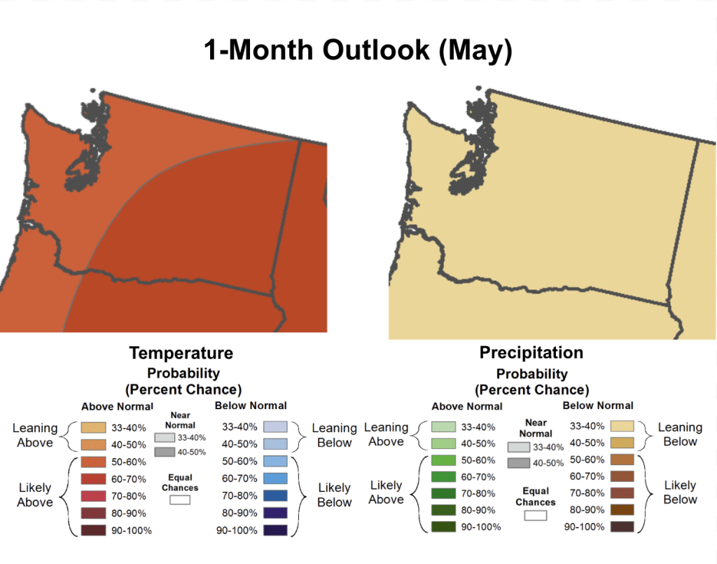 1-month (May) outlook for temperature (left) and precipitation (right) in Washington State.
Taking a look at the 1-month outlook for May, there are elevated chances of both warmer than normal and drier than normal conditions. There is higher confidence in the temperature outlook with a 50-60% chance of warmer than normal temperatures across western and north central Washington and a slightly higher 60-70% chance of warm conditions across central and eastern Washington. The 1-month precipitation outlook shows only slightly elevated chances (33-40% chance) of drier than normal conditions statewide.
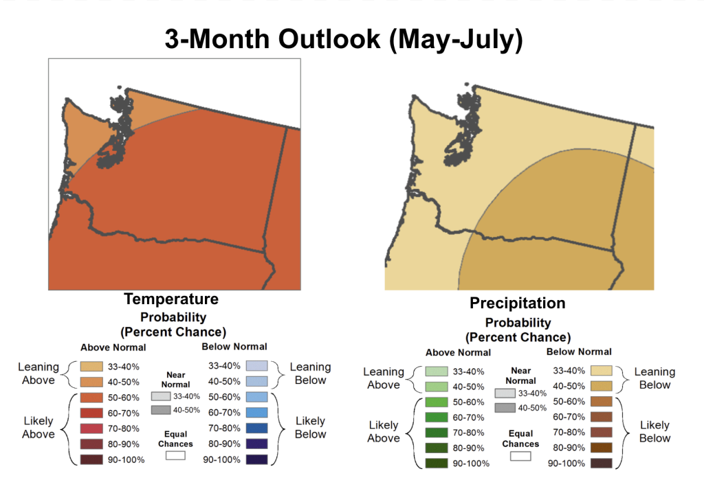 3-month (May, June, and July) outlook for temperature (left) and precipitation (right) in Washington State.
The 3-month outlook for May-July shows these warmer and drier than normal conditions may continue into the middle of summer. There is a 50-60% chance of warmer than normal conditions nearly statewide with a 40-50% chance across far northwestern Washington. As for precipitation, odds of drier than normal conditions are elevated with a 33-40% chance of dry conditions across western and northern Washington and a 40-50% chance of dry conditions across the southeastern quarter of the state. This includes areas stretching from Yakima to Moses Lake to Spokane along with areas to the southeast.
These warm and dry outlooks are not ideal, particularly given our near record low snowpack and early snowmelt thus far this spring. We will continue to monitor conditions as summer approaches.