By Jacob Genuise
Key Messages:
- El Niño continues to intensify. Positive SST anomalies are currently breaking all-time daily records.
- The 1-month October outlook shows elevated chances of warmer and drier than normal conditions across much of the state.
- The 3-month October-December outlook shows elevated chances of warmer than normal conditions statewide and drier than normal conditions across the eastern half of the state as El Niño is expected to begin to more strongly influence statewide conditions.
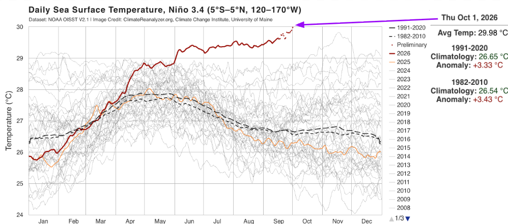 Daily SST anomalies in the Niño 3.4 region of the tropical Pacific.
El Niño has continued to strengthen in the tropical Pacific. Daily sea surface temperatures (SSTs) in the official Niño 3.4 region are now warmer than on any other single day since at least 1981 (data are preliminary) according to data from NOAA OISST V2.1. These data are plotted above using the University of Maine’s Climate Reanalyzer tool. In this plot, the red line represents this year’s SSTs which have increased relative to normal over the past several months. Normal conditions are represented by the dashed black lines and show this region is typically cooling throughout the summer period. This year, temperatures have either plateaued or warmed during this period. SSTs reached +3.33°C above normal on October 1, 2026, which is now a larger anomaly than the peak annual anomaly during the very strong 2015 El Niño event (3.04°C on November 19, 2015). These record warm water temperatures are also occurring more than a month earlier than in 2015.
The animation below shows a 15-day running mean of SSTs in the tropical Pacific. This warm region of water is a telltale sign of a rapidly strengthening El Niño. Forecasts indicate SSTs are likely to continue to warm even more through the fall. These remarkable conditions in the tropical Pacific increase the probability that we will see impacts from El Niño in Washington this winter including a higher chance of above normal temperatures and below normal snowpack. In case you missed it, please read last month’s Climate Matters piece to learn more about how the upcoming winter may play out.
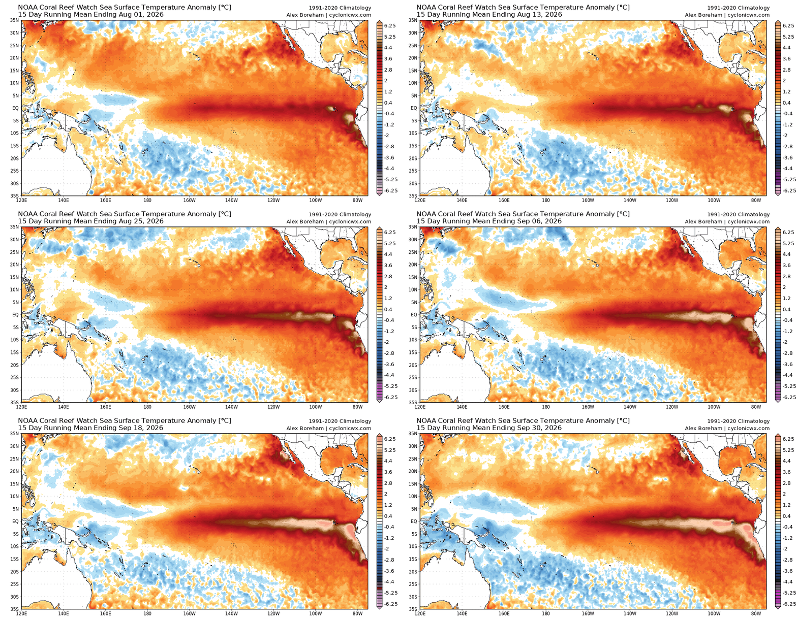 15-day mean SST anomalies in the tropical Pacific. Warmer colors represent warmer temperatures. Source: https://cyclonicwx.com/sst/
1-month and 3-month Outlooks
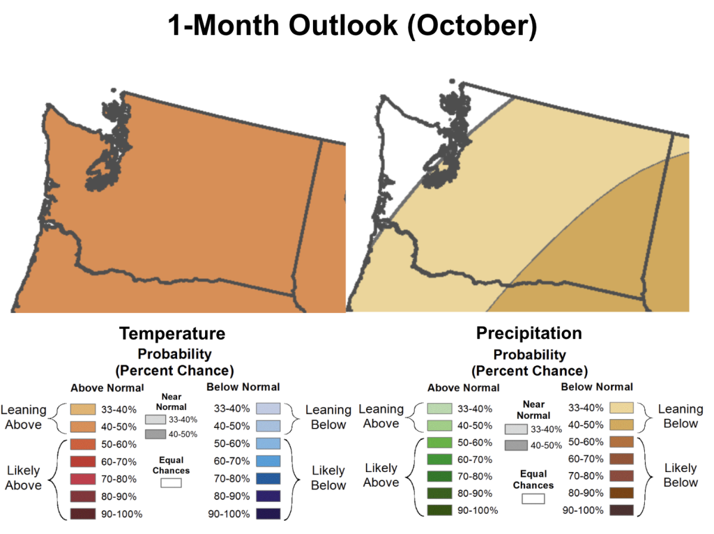 1-month (October) outlook for temperature (left) and precipitation (right) in Washington State.
The 1-month outlook for October from the Climate Prediction Center indicates a return to drier and warmer than normal conditions across much of the state. There is an elevated 40-50% chance of warmer than normal temperatures statewide. There is a 40-50% chance of drier than normal conditions across the southeastern corner of the state and a lower 33-40% chance of drier than normal conditions southeast of a line stretching from Long Beach to the North Cascades including parts of southern Puget Sound.
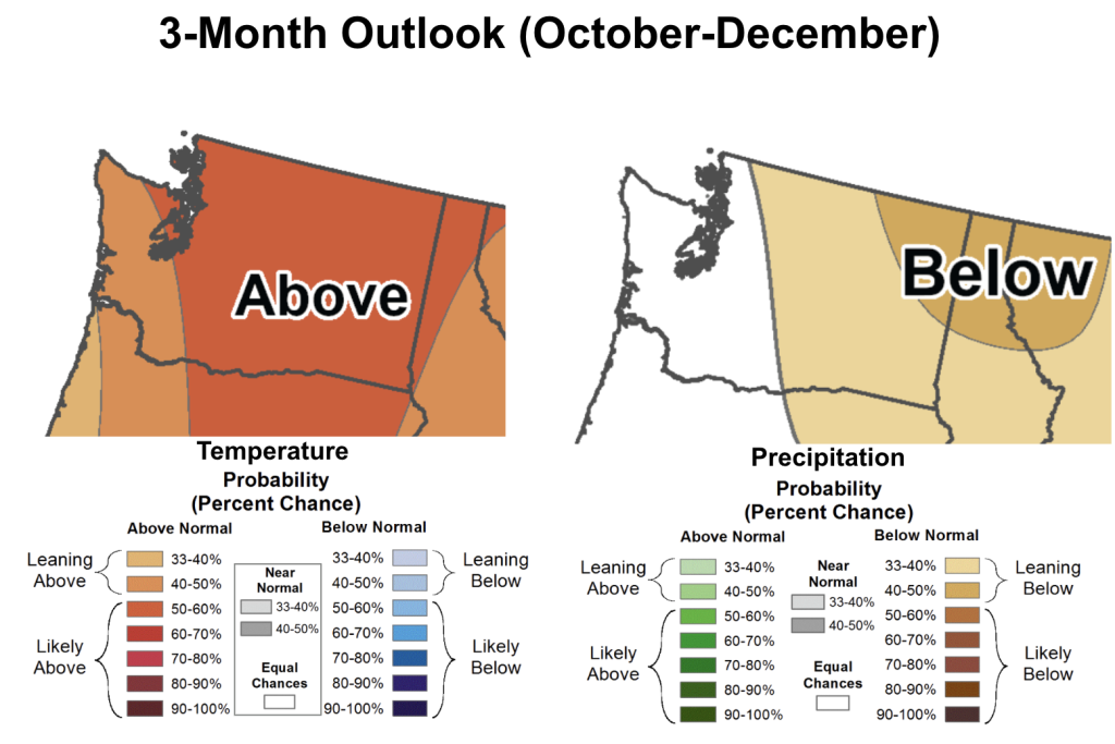 3-month (October, November, December) outlook for temperature (left) and precipitation (right) in Washington State.
The 3-month outlook through December also shows a similar signal for warmer than normal and possibly drier than normal conditions in parts of the state. There is a 50-60% chance of warmer than normal conditions across the majority of the state and a 40-50% chance of warmer than normal conditions across the outer Coast and the Vancouver metro.
Elevated chances of drier than normal conditions exist across the far northeast corner of the state with lesser chances across central Washington and the central and northern Cascades. Much of western Washington has equal chances of above, below, or near-normal precipitation now through December.