By Jacob Genuise
Key Messages:
- Very strong El Niño conditions continue in the tropical Pacific. The latest seasonal RONI index for August-October was +2.0°C. Some continued strengthening is possible before reaching peak strength sometime in the October-December period.
- The 1-month November outlook shows elevated chances of warmer than normal temperatures statewide. Precipitation is less certain, with elevated chances of drier than normal conditions in the far northeast and wetter-than-normal conditions in the west.
- The 3-month November-January outlook shows elevated chances of warmer than normal conditions statewide and a slightly elevated chance of drier than normal conditions across far northeastern Washington
 NOAA ENSO strength probability forecast. Each bar represents a 3-month season with each letter corresponding to a single month. For example, “SON” corresponds to a forecast for the September-October-November period. Seasonal periods overlap. Shading represents the probability of various ENSO strengths and type, with dark red shading representing very strong El Niño conditions, gray representing neutral conditions, and blue representing La Niña conditions.
El Niño has continued to strengthen in the tropical Pacific and sea surface temperature anomalies reached +2.0°C for the August-October period. The above graphic shows a high likelihood of this very strong event continuing through mid-winter before weakening rapidly to a moderate or weak event sometime in late winter or spring. Strong El Niño events often break down quickly and return to neutral or La Niña conditions by the following year. The long range CPC outlook above is beginning to pick up on this transition toward Neutral or La Niña conditions, but we are still a long way out from knowing what ENSO phase may develop next.
The official ENSO strength outlook below shows some additional strengthening is likely over the next month or so before a peak sometime in November through January near +2.6°C. If this forecast verifies, this will be the strongest El Niño event since at least 1950, as measured by the relative ENSO index.
 NOAA’s official ENSO strength probabilistic outlook. Darker blues indicate a more likely range of strength, as measured by the Relative Oceanic Niño Index (RONI).
1-month and 3-month Outlooks
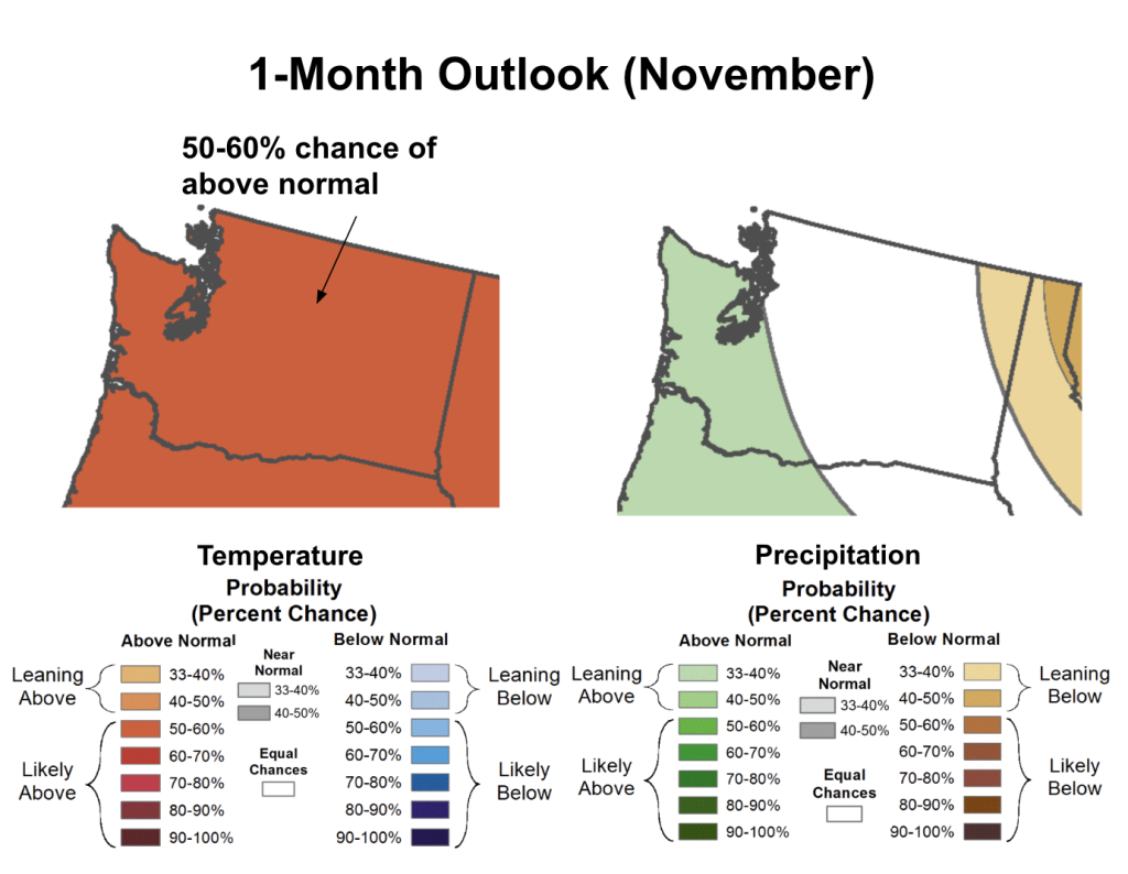 1-month (November) outlook for temperature (left) and precipitation (right) in Washington State.
The 1-month outlook for November from the Climate Prediction Center shows elevated chances (50-60%) of above normal temperatures statewide.
The outlook for precipitation in November is less certain. Across the outer coast, central and southern Puget Sound and south central Washington, there is a slightly elevated chance (33-40%) of above normal precipitation. Northern Puget Sound and central and southeastern Washington have equal chances of above, below, or near normal precipitation. The northeast corner of the state has slightly elevated chances (33-40%) of below normal precipitation.
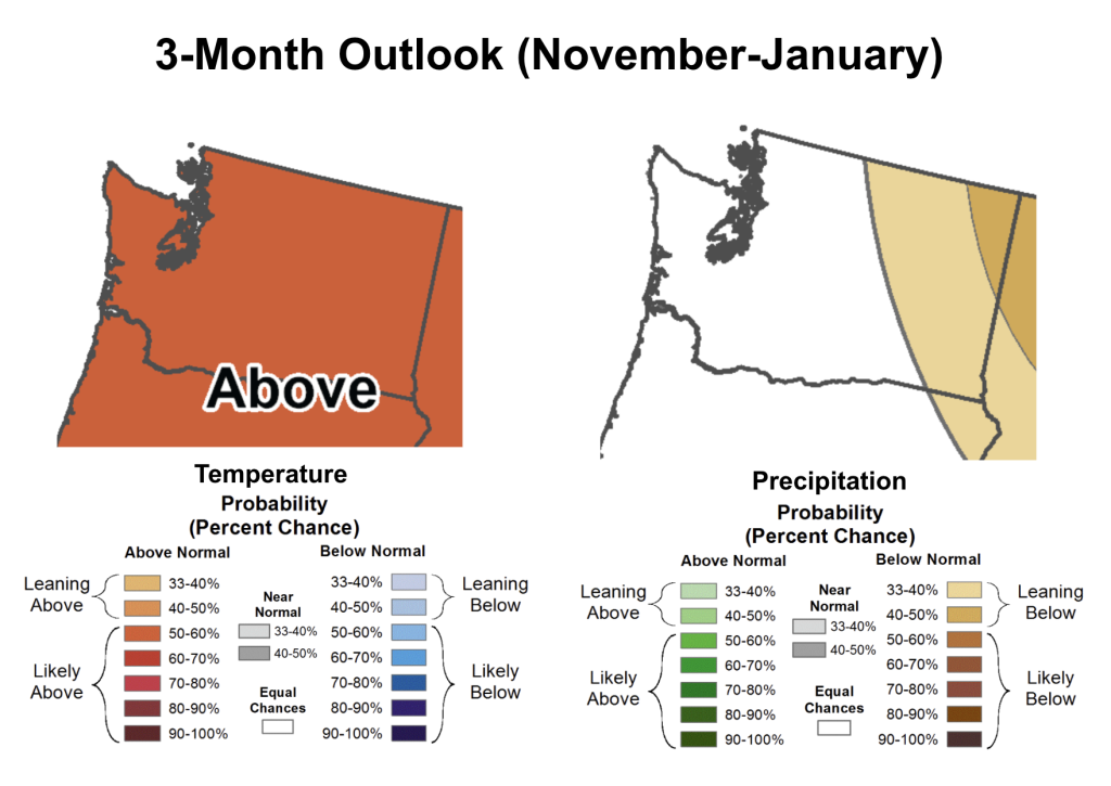 3-month (November, December, January) outlook for temperature (left) and precipitation (right) in Washington State.
The 3-month outlook for November through January shows a 50-60% chance of above normal conditions statewide. This is consistent with what we would expect during a strong El Niño event. Precipitation is less certain, but elevated chances (40-50%) of below normal precipitation exist toward the far northeastern corner of the state. Slightly lower odds of drier than normal conditions exist in Okanogan County, Spokane, and near Walla Walla and Pullman.